Tuttington
| Tuttington | |
|---|---|
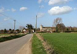 Approach to Tuttington from the south | |
 Tuttington Tuttington shown within Norfolk | |
| OS grid reference | TG220270 |
| • London | 129 miles (208 km) |
| Civil parish | |
| District | |
| Shire county | |
| Region | |
| Country | England |
| Sovereign state | United Kingdom |
| Post town | AYLSHAM |
| Postcode district | NR11 |
| Dialling code | 01263 |
| Police | Norfolk |
| Fire | Norfolk |
| Ambulance | East of England |
| EU Parliament | East of England |
Tuttington is a village is located in the civil parish of Burgh and Tuttington , in the English county of Norfolk.[1] The village is 11.1 miles south of Cromer, 15 miles north of Norwich and 129 miles north-east of London. The village lies 3 miles east of the nearby town of Aylsham. The nearest railway station is at North Walsham for the Bittern Line which runs between Sheringham, Cromer and Norwich. The nearest airport is Norwich International Airport.
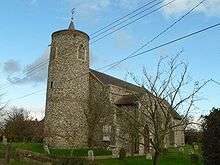
Its church, St Peter and St Paul, is one of 124 existing round-tower churches in Norfolk.
Opposite the church, there is a Dutch gabled building that used to be the village shop and post office, which closed in May 1987. Next door to that there used to be a pub called The Ship. It has been said that as the village is several miles from the sea or any navigable waterways, this name could be a corruption of The Sheep as the pub may have been a welcome watering hole for drovers.
References
External links
![]()