Bittern Line
.JPG)
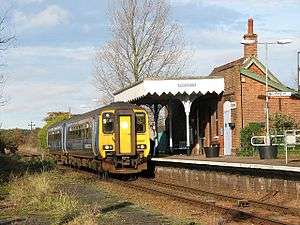
The Bittern Line is a railway branch line in Norfolk, England, that links Norwich to Sheringham.[1] It passes through the Broads on its route to an Area of Outstanding Natural Beauty on the north Norfolk coast.[2] It is named after the bittern, a rare bird found in the reedy wetlands of Norfolk.
The line is 30 miles 22 chains (48.7 km) in length and there are 10 stations. It is part of Network Rail Strategic Route 7, SRS 07.11, and is classified as a rural line.[3]
Passenger services are operated by Greater Anglia, which also manages all of the stations.
History
The line was granted permission in 1864 [4] and opened between Norwich and North Walsham in 1874 by the East Norfolk Railway, and was extended to Cromer by 1877. The rest of the line, between Cromer and Sheringham, was opened in 1887 using a section of the Midland and Great Northern Joint Railway line (a further section of the Midland and Great Northern Joint Railway running from Sheringham to Holt is preserved as the North Norfolk Railway). From the early twentieth century until the end of steam services, in 1962, the Great Eastern Railway operated coastal holiday services from London Liverpool Street under names such as 'Norfolk Coast Express' and the 'Broadsman'. [4]
The Bittern Line Partnership was set up by Norfolk County Council in 1997.
In November 2006 track renewal work began with whole lengths of the old track being lifted and new rails and sleepers being installed, along with new level crossing points. The work was carried out by Balfour Beatty on behalf of Network Rail.
The line was designated a community rail line by the Department for Transport in September 2007.
.JPG)
After a period of 36 years, the link between the Bittern line and the North Norfolk Railway was reinstated in 2010 on the occasion of the opening of a new level crossing at Sheringham.
Passenger numbers are increasing, and the route has seen a number of service improvements in recent years, including additional services on the timetable.
Route
The towns and villages served by the route are:[5]
- Norwich (connection with the Great Eastern Main Line, Breckland line and Wherry lines)
- Salhouse
- Hoveton and Wroxham[6] (connection with the Bure Valley heritage railway)
- Worstead
- North Walsham
- Gunton (for Northrepps Aerodrome)
- Roughton Road (a suburb of Cromer)
- Cromer (trains reverse)
- West Runton (for Beeston Regis)
- Sheringham (connection with the North Norfolk heritage railway)
Services
Passenger services are operated by Greater Anglia. The typical service is one train per hour in each direction between Norwich and Sheringham. Calling patterns are varied, with some trains stopping at all stations while others omit some of the lesser-used stations along the line, such as Salhouse, Gunton and Roughton Road.
Trains are typically formed of Class 153, Class 156 and Class 170 diesel multiple units.
The line is also used by freight trains which are operated by GB Railfreight, part of Groupe Eurotunnel S.A. Some trains carry gas condensate from a terminal at North Walsham to Harwich.
Infrastructure
The line is double-track from Norwich to Hoveton and Wroxham, where the line becomes single-track, with a passing loop at North Walsham, and two platforms at Cromer also allowing passing. The line is not electrified; it has a loading gauge of W8 between Norwich and Roughton Road and W6 from Roughton Road to Sheringham. The maximum speed is 75 mph.[3]
The line was re-signalled in 2000, leading to the closure of a number of mechanical signal boxes with control moving to a panel at the Trowse Swing Bridge control room. This saw the end of one of the few remaining sections of single-track main line controlled by tokens. The Cromer signal box has been preserved.
Proposed developments
Rackheath station
A new station is proposed as part of the Rackheath eco-town.[7] The building of the town may also mean a short freight spur being built to transport fuel to fire an on-site power station. The plans for the settlement received approval from the government in 2009.[8]
References
- ↑ "Home". Bittern Line.
- ↑ OS Explorer Map 252 – Norfolk Coast East. ISBN 978-0-319-23815-8
- 1 2 "Route 7 - Great Eastern" (PDF). Network Rail. Retrieved 2009-05-20.
- 1 2 Holland, Julian; Spaven, David (2012). Britain's Scenic Railways. Fulham Palace Road, London: Times Books Group Ltd. pp. 78–81. ISBN 978-0-00-792671-8.
- ↑ "Archived copy" (PDF). Archived from the original (PDF) on 26 May 2011. Retrieved 2008-11-16.
- ↑ Ordnance Survey (2005). OS Explorer Map OL40 - The Broads. ISBN 0-319-23769-9.
- ↑ "Transport". Rackheath eco-community.
- ↑ "Airfield eco-town plan selected". BBC News. 2009-07-16. Retrieved 2009-07-19.
External links
| Wikimedia Commons has media related to Bittern Line. |
| Primary |
|  | ||||
|---|---|---|---|---|---|---|
| Secondary | ||||||
| Others |
| |||||
| Heritage | ||||||