Tunjice
| Tunjice | |
|---|---|
 | |
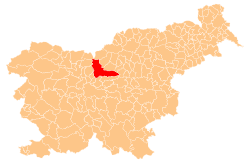
 Tunjice Location in Slovenia | |
| Coordinates: 46°14′3.86″N 14°34′25.29″E / 46.2344056°N 14.5736917°ECoordinates: 46°14′3.86″N 14°34′25.29″E / 46.2344056°N 14.5736917°E | |
| Country |
|
| Traditional region | Upper Carniola |
| Statistical region | Central Slovenia |
| Municipality | Kamnik |
| Area | |
| • Total | 3.61 km2 (1.39 sq mi) |
| Elevation | 370 m (1,210 ft) |
| Population (2002) | |
| • Total | 246 |
| [1] | |
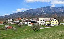
Tunjice (pronounced [ˈtuːnjitsɛ]; German: Theinitz[2]) is a dispersed settlement in the Tunjice Hills (Slovene: Tunjiško gričevje) west of the town of Kamnik in Upper Carniola region of Slovenia.
In the forest close to the church a "natural healing grove" with several "energy springs," known as the Tunjice Natural Health Resort, has been established.[3]
Church
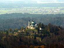
St. Anne's Church with Tunjice in the background
The parish church, dedicated to Saint Anne, stands on a hill above the settlement and is an imposing High-Baroque domed building. It was constructed on the order by Peter Pavel Glavar from 1761–66 upon the plans by the architect Lovrenc Prager.[4]
Notable people
Notable people that were born or lived in Tunjice include:
- France Stele (1886–1972), art historian and conservation specialist
References
- ↑ Statistical Office of the Republic of Slovenia
- ↑ Leksikon občin kraljestev in dežel zastopanih v državnem zboru, vol. 6: Kranjsko. 1906. Vienna: C. Kr. Dvorna in Državna Tiskarna, p. 30.
- ↑ Slovenian Tourist Board site
- ↑ Vidrih, Rebeka. "Cerkev sv. Ane v Tunjicah". In Šmid Hribar, Mateja; Golež, Gregor; Podjed, Dan; Kladnik, Drago; Erhartič, Bojan; Pavlin, Primož; Ines, Jerele. Enciklopedija naravne in kulturne dediščine na Slovenskem – DEDI [Encyclopedia of Natural and Cultural Heritage in Slovenia] (in Slovenian). Retrieved 22 July 2012.
External links
| Wikimedia Commons has media related to Tunjice. |
This article is issued from
Wikipedia.
The text is licensed under Creative Commons - Attribution - Sharealike.
Additional terms may apply for the media files.