Toyama Prefecture
| Toyama Prefecture 富山県 | |||
|---|---|---|---|
| Prefecture | |||
| Japanese transcription(s) | |||
| • Japanese | 富山県 | ||
| • Rōmaji | Toyama-ken | ||
| |||
 | |||
| Coordinates: 36°43′N 137°9′E / 36.717°N 137.150°ECoordinates: 36°43′N 137°9′E / 36.717°N 137.150°E | |||
| Country | Japan | ||
| Region | Chūbu (Hokuriku) | ||
| Island | Honshu | ||
| Capital | Toyama | ||
| Government | |||
| • Governor | Takakazu Ishii | ||
| Area | |||
| • Total | 4,247.22 km2 (1,639.86 sq mi) | ||
| Area rank | 33rd | ||
| Population (Estimated as of March 1, 2018) | |||
| • Total | 1,053,555 | ||
| • Rank | 38th | ||
| • Density | 248.06/km2 (642.5/sq mi) | ||
| ISO 3166 code | JP-16 | ||
| Districts | 2 | ||
| Municipalities | 15 | ||
| Flower | Tulip (Tulipa)[1] | ||
| Tree | Tateyama Cedar (Cryptomeria japonica)[1] | ||
| Bird | Ptarmigan[1] | ||
| Fish |
Japanese amberjack Pasiphaea japonica Firefly squid[1] | ||
| Website | pref.toyama.jp | ||


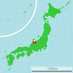
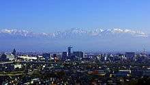
Toyama Prefecture (富山県 Toyama-ken) is a prefecture of Japan located in the Hokuriku region on the main Honshu island.[2] The capital is the city of Toyama.[3]
Toyama is the leading industrial prefecture on the Japan Sea coast, and has the industrial advantage of cheap electricity from abundant hydroelectric resources. It also contains East Asia's only known glaciers outside Russia, first recognized in 2012.[4]
History
Historically, Toyama Prefecture was Etchū Province.[5] Following the abolition of the han system in 1871, Etchū Province was renamed Niikawa Prefecture, but Imizu District was given to Nanao Prefecture. In 1872 Imizu District was returned by the new Ishikawa Prefecture.
In 1876, Niikawa Prefecture was merged into Ishikawa Prefecture but the merger was void in 1881 and the area was re-established as Toyama Prefecture.
The Itai-itai disease occurred in Toyama around 1950.
Geography
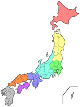
Toyama Prefecture is bordered by Ishikawa Prefecture to the west, Niigata to the northeast, Nagano to the southeast, Gifu to the south and Sea of Japan to the north.
As of April 1, 2012, 30% of the total land area of the prefecture was designated as Natural Parks, namely the Chūbu-Sangaku and Hakusan National Parks; Noto Hantō Quasi-National Park; and six Prefectural Natural Parks.[6]
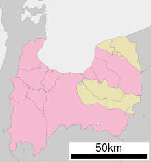
Municipalities
City Town Village
Due to the mergers in the 2000s, Toyama has the fewest municipalities of any prefecture in Japan with 10 cities, 2 districts, 4 towns, and 1 village (before the mergers took place, the prefecture had 9 cities, 18 towns, and 8 villages).
Cities
Ten cities are located in Toyama Prefecture:
Towns and villages
These are the towns and villages in each district:
Mergers
Economy
Agriculture
In 2014 Toyama contributed approximately 2.5% of Japan's rice production [7] and makes use of abundant water sources originating from Mount Tate. It also has many fisheries along its Sea of Japan coastline.
Manufacturing
Toyama is famous for its historical pharmaceutical industry which remains a top manufacturing industry in the prefecture in terms of manufacturing shipment value followed by electronic parts and devices (industrial robots, general machinery, etc.), and metal products (aluminum, copper etc.) manufacturing.
Energy
.jpg)
Kurobe Dam generates electricity for the Kansai Electric Power Company. It is located on the Kurobe River in Toyama Prefecture.
Demographics
As of 2010, the population of the prefecture was 1,090,367.[8]
International links


Transportation
Rail
Tokyo: 2 hr 7 min via Hokuriku Shinkansen
Osaka: 3 hr via Hokuriku Shinkansen and Thunderbird Limited Express
- The Hokuriku Shinkansen line is scheduled to extend to Osaka in the future, and will shorten the Osaka-Toyama trip to approximately 1 hr 40 min.
Expressway
Air
- Toyama Airport (TOY)
Domestic
International
- Shanghai: 2 hr 30 min via Shanghai Airlines
- Dalian: 2 hr 30 min via China Southern Airlines
- Seoul: 1 hr 50 min via Asiana Airlines
- Vladivostok: 2 hr 40 min via Vladivostok Airlines
Culture
UNESCO World Heritage Cultural Sites
National Treasures of Japan
Festivals
Spring
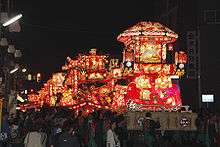
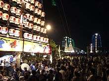
- All Japan Chindon Competition (Toyama City (Toyama Castle Park), Mid April
- Tonami Tulip Fair (Tonami City), May
- Marumage Festival (Himi City), May 17
Summer
- Sassa Narimasa Sengoku Era Festival (Toyama City), Late July
- Japan Wildlife Film Festival (Toyama Prefecture), Early August
Fall
- Toyama Festival (Toyama City), Sept. 1
- Owara Kaze no Bon (Toyama City (Yatsuo Area)), Sept. 1-3
Winter
- Nanto Toga Soba Festival (Nanto City (Toga Village Area)), Mid Feb.
Regional Foods
- Trout Sushi (Masu Zushi)
- White Shrimp (Shiro Ebi)
- Matured Yellow Tail (Buri)
- Firefly Squid (Hotaru Ika)
- Fish Paste (Kamaboko)
Regional sake
- Tateyama (立山)
- Narimasa (成政)
- Masuizumi (満寿泉)
- Sanshoraku (三笑楽)
Sports
The sports teams listed below are based in Toyama.
Football (soccer)
Basketball
Baseball
Rugby Union
- Takaoka Mariners (Takaoka)
Sister Regions
Tourism
Notes
- 1 2 3 4 富山県の魅力・観光>シンボル. Toyama Prefectural website (in Japanese). Toyama Prefecture. Retrieved 9 September 2011.
- ↑ Nussbaum, Louis-Frédéric. (2005). "Toyama prefecture" in Japan Encyclopedia, p. 991, p. 991, at Google Books; "Hokuriku" at p. 344, p. 344, at Google Books.
- ↑ Nussbaum, "Toyama" at p. 991, p. 991, at Google Books.
- ↑ First glaciers of Japan recognised
- ↑ Nussbaum, "Provinces and prefectures" at p. 780, p. 780, at Google Books.
- ↑ "General overview of area figures for Natural Parks by prefecture" (PDF). Ministry of the Environment. Retrieved 29 June 2012.
- ↑ "米の生産 〔2014年〕" (in Japanese). Retrieved May 11, 2015.
- ↑ "Location - Area - Population". Toyama Prefecture. Retrieved December 26, 2017.
- 1 2 Sister/Friendship Affiliation
- ↑ Oregon State Archives Copy, Governor's Office Press Releases
References
- Nussbaum, Louis-Frédéric and Käthe Roth. (2005). Japan encyclopedia. Cambridge: Harvard University Press. ISBN 978-0-674-01753-5; OCLC 58053128
External links
| Wikimedia Commons has media related to Toyama prefecture. |
- Official Toyama Prefecture Homepage
- Toyama Prefecture International Center
- National Archives of Japan Toyama Map (1891)
| Core city | ||
|---|---|---|
| Cities | ||
| Districts | ||
| Authority control |
|---|