Mount Tate
| Mount Tate | |
|---|---|
| Tateyama, 立山 | |
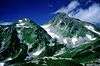
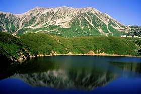 Mount Tate (Mt. Fuji-no-Oritate, Mt. Oonanji, Mt. O) and Mikuri Pond | |
| Highest point | |
| Elevation | 3,015 m (9,892 ft) [1] |
| Listing |
List of mountains in Japan 100 Famous Japanese Mountains |
| Coordinates | 36°34′33″N 137°37′11″E / 36.57583°N 137.61972°ECoordinates: 36°34′33″N 137°37′11″E / 36.57583°N 137.61972°E [1] |
| Naming | |
| Translation | Standing Mountain (Japanese) |
| Geography | |
 Mount Tate Location in Japan | |
| Location | Toyama Prefecture, Japan |
| Parent range | Hida Mountains |
| Topo map |
Geospatial Information Authority 25000:1 剱岳[1] 50000:1 立山 |
| Climbing | |
| First ascent | Saeki no Ariyori ca. 8th century |
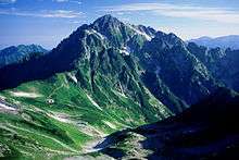
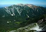
Mount Tate (立山 Tate-yama, IPA: [tate]) (commonly referred to as simply Tateyama) is located in the southeastern area of Toyama Prefecture, Japan. It is one of the tallest mountains in the Hida Mountains at 3,015 m (9,892 ft) and, along with Mount Fuji and Mount Haku, it is one of Japan's "Three Holy Mountains" (三霊山 Sanreizan). Tateyama is a term for the mountain consisting of three peaks: Ōnanjiyama (大汝山, 3,015m), Oyama (雄山, 3,003m), and Fuji-no-Oritateyama, (富士ノ折立, 2,999m)[2] which run along a ridge (see photo) . Tateyama is the tallest mountain in the Tateyama Mountain Range (立山連峰, Tateyama-renpō).
It was first climbed by Saeki no Ariyori during Japan's Asuka period. The area was designated the Chūbu-Sangaku National Park on December 4, 1934.[3][4]
Name
The kanji for the mountain (立山 Tateyama), which is called Tateyama in Japanese, mean "standing 立 or outstanding 顕" and "mountain", respectively. The pronunciation of tate is two syllables similar to tah-tei rather than gate. The Toyama Prefectural Government uses the name Mount Tateyama as an official translation of the Japanese mountain. English-speaking locals tend to use the Japanese name Tateyama when referring to the mountain.
Geology
The mountain is composed primarily of granite and gneiss. However, located along the ridge and plateau about 2 km (1.2 mi) west of the summit is a small andesite-dacite stratovolcano.[5] This volcano has an elevation of 2,621 m (8,599 ft), and has had minor historical eruptions, the latest in 1839.
Geography
Location
Tateyama is located in southeastern Toyama Prefecture. At the base of the mountain is the town of Tateyama, which is accessible by train from the prefecture's capital city, Toyama. Public transportation will take climbers and tourists as far as the Murodo Plateau Station at an elevation of 2,450 m (8,038 ft), from where individuals may climb to the peak on foot. These are the only glaciers identified in Japan so far.[6]
Nearby mountains
| Image | Mountain | Elevation | Distance and direction from the Top |
Note |
|---|---|---|---|---|
 |
Mt. Tsurugi 剱岳 |
2,999 m (9,839 ft) | 5.3 km (3.3 mi) North |
100 Japanese Mountains |
 |
Mt. Bessan 別山 |
2,880 m (9,449 ft) | 2.4 km (1.5 mi) North |
|
 |
Mt. Tate 立山 |
3,015 m (9,892 ft) | 0 km (0.0 mi) | 100 Famous Japanese Mountains the tallest mountain in Toyama Prefecture |
 |
Mt. Ryūō 龍王岳 |
2,872 m (9,423 ft) | 1.7 km (1.1 mi) Southwest |
|
 |
Mt. Harinoki 針ノ木岳 |
2,820.60 m (9,254 ft) | 7.2 km (4.5 mi) Southeast |
200 Japanese Mountains |
 |
Mt. Akaushi 赤牛岳 |
2,864.23 m (9,397 ft) | 12.8 km (8.0 mi) South |
200 Japanese Mountains |
 |
Mt. Yakushi 薬師岳 |
2,926.01 m (9,600 ft) | 13.7 km (8.5 mi) Southwest |
100 Japanese Mountains |
Rivers
The mountain is the source of the following rivers, each of which flows to the Sea of Japan.[7]
- Hayatsuki River
- Tsurugisawa, tributaries of the Kurobe River
Mountain sights
Located by the Oyama peak is Oyama Shrine, where climbers can receive a blessing and warm sake from a priest. There is also a rest area where climbers may buy food, drinks, and souvenirs. This peak is better known but it is some way from the highest point of the mountain (Onanjiyama).
On Murodo Plateau the contains Murodō Station is a shopping area and onsen bath. The onsen on Tateyama is famously known for its use of sulfur spring water for the bath, leaving a noticeable aroma that can be detected even while ascending the mountain. Visitors can also find several hiking and walking paths that take them through the beautiful valleys, and take a look at Devil's Valley (Jigokudani). With many volcanic areas in Japan by the same name, visitors are no longer able to walk within the sulfur valley due to gas-related safety concerns. Murodo is a great place to hike from mid-July to mid-November. The summer months are dappled with greenery and some leftover snow from winter, while from mid-September, visitors can enjoy bright autumn colors along the entire route.
There are charter services from Taipei, Inchon and Thailand during the high season to reach Murodo.
From Murodo, visitors can also reach Kurobe Dam, which stands at 186 meters (610 feet), making it the tallest dam in Japan. From Murodō Station, visitors should take the Tateyama Tunnel Trolleybus (10 minutes), followed by the Tateyama Ropeway (7 minutes), and finally the Kurobe Cable Car (5 minutes). From the last stop, a 15-minute walk will take visitors to the dam.
Midagahara is a flat walking area filled with flowing plains interrupted by blue ponds. Near the bus stop that returns visitors to Bijodaira back down the mountain is a slightly hidden walking path. Midagahara is accessible from Tateyama Station via the Tateyama Cable Car (7 minutes) followed by Tateyama Kurobe Alpine Route bus (about 40 minutes) that goes in the direction of Murodō Station.
On clear days, climbers can see Shōmyō Falls (the tallest waterfall in Japan) across the valley while traveling along the main road from Tateyama Station to the Murodo Plateau. For a closer look, visitors can take a bus from Tateyama Station to the Shōmyō Falls stop (about 20 minutes). From there, visitors can walk to the falls up a steady slope (about 20 minutes). There is a large bridge as well as two viewing platforms to get views of the Falls.
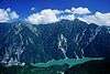
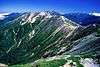
Scenery of Tateyama
 Tateyama from Higashi-Ichinokoshi
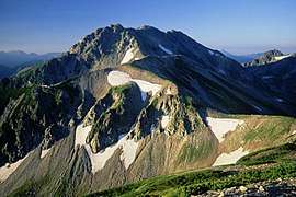 Tateyama from Mt. Bessan
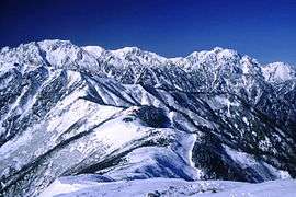 Tateyama and Mt. Tsurugi from Mt. Jii
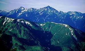 Tateyama and Mt. Tsurugi from Mt. Asahi
References
- 1 2 3 "Map inspection service" (in Japanese). Geospatial Information Authority of Japan,(高山-立山-剱岳). Retrieved January 28, 2011.
- ↑ http://maps.gsi.go.jp/#15/36.575910/137.619592/&base=std&ls=std&disp=1&vs=c1j0l0u0f0
- ↑ "Chūbu-Sangaku National Park". Ministry of the Environment (Japan). Archived from the original on February 27, 2012. Retrieved January 28, 2011.
- ↑ http://www.gsi.go.jp/KOKUJYOHO/MOUNTAIN/mountain.html
- ↑ "Tate-yama". Global Volcanism Program. Smithsonian Institution.
- ↑ "3 snow patches in central Japan certified as glaciers". Asahi Shimbun. February 7, 2018. Retrieved July 30, 2018.
- ↑ Mountain and plateau map of Mount Tsurugi and Tateyama (in Japanese). Shobunsha Publications,
ISBN 978-4-398-75716-6. 2010. templatestyles stripmarker in
|publisher=at position 24 (help)
External links
| Wikimedia Commons has media related to Mount Tate. |
| Wikivoyage has a travel guide for Mount Tate. |
See also
- Chūbu-Sangaku National Park
- Japanese Alps
- List of mountains in Japan
- Three-thousanders (in Japan)
- Tateyama Kurobe Alpine Route
- Tateyama Sabō Erosion Control Works Service Train
- Tateyama, Toyama
- Tateyama Station (Toyama)
- Murodō Station
- Kurobe dam
- Tourism in Japan
| Wikimedia Commons has media related to Mount Tate. |
| Hokkaidō | |||||||||
|---|---|---|---|---|---|---|---|---|---|
| Tōhoku region Jōshinetsu region |
| ||||||||
| Kantō region | |||||||||
| Chūbu region |
| ||||||||
| Western Japan | |||||||||
| |||||||||