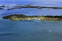
Toronto Islands
.JPG)
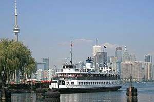
The Toronto Islands (formerly known as Island of Hiawatha and also known as Menecing, meaning "On the Island" in the Ojibwa language)[1][2] are a chain of small islands in Lake Ontario, south of mainland Toronto, Ontario, Canada. Comprising the only group of islands in the western part of Lake Ontario, the Toronto Islands are located just offshore from the city centre, and provide shelter for Toronto Harbour. The islands are home to parkland, the Billy Bishop Toronto City Airport, several yacht clubs, Centreville Amusement Park, and Hanlan's Beach. The island community is considered to be the largest urban car-free community in North America, although some service vehicles are permitted. Access to the Islands is by ferry, including the City of Toronto ferries operating from Jack Layton Ferry Terminal at the foot of Bay Street, or by water taxis.
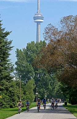
The island is a popular recreation destination. Recreational bicyclists are accommodated on the ferries. There is a public bicycle sharing station operated by Bike Share Toronto at Jack Layton Ferry Terminal and bicycles and quadracycles can be rented at Centre Island. Canoes, kayaks and paddle boats can also be rented on the island. A frisbee golf course exists on the island. The main beach is along the south shore and the beach on the west shore is clothing-optional. There is ample park land suitable for picnicking which is popular, several playgrounds, and several gardens.
History
Prior to European colonization, the Toronto area was home to various native peoples, including the Anishinaabeg (known also as the Ojibwa and Mississaugas) who were the last to occupy the area. The Anishinaabeg, who named the peninsula (as it was at the time ) "Menecing", brought their sick to the peninsula to recover in its healthful atmosphere.[3] To the descendants of the Ojibwa, now the Mississaugas of the New Credit First Nation, the Toronto Islands are sacred land. The Toronto Purchase of 1787 and 1805, according to the British, included the Islands. The Mississaugas, in a land claim settlement process started in 1986, claimed that the Islands were never included. In 2010, the Government of Canada and the Mississaugas reached a settlement which resulted in a cash payment to the Mississaugas from the Government of Canada. In return, the Mississaugas relinquished their claim to the islands.[4]
The peninsula and surrounding sand-bars that now form the Toronto Islands were first surveyed in 1792 by Lieutenant Joseph Bouchette of the Royal Navy. D. W. Smith's Gazetteer recorded in 1813 that "the long beach or peninsula, which affords a most delightful ride, is considered so healthy by the Indians that they resort to it whenever indisposed". Many aboriginal encampments were located between the peninsula's base and the Don River.[5] The peninsula was actually a series of many sand spits and ponds.
During the 1790s, the British built the first buildings on the Island. A blockhouse and storage structures were built at Gibraltar Point in 1794. The garrison was known as the Blockhouse Bay garrison, and it supported the garrison on the mainland. By 1800, another blockhouse and a guard house were built. These were destroyed in the Battle of York. Another garrison was built, but it was abandoned by 1823 and demolished in 1833.[6]
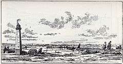
The Gibraltar Point Lighthouse was constructed at Gibraltar Point, the south-western extremity of the peninsula in 1809. It is perhaps best known for the demise of its first keeper, German-born John Paul Radelmüller, whose alleged 1815 murder by soldiers from Fort York forms the basis of Toronto’s most enduring ghost story.[7][8] Although the precise circumstances of his death remain a mystery, recent research has verified many aspects of the popular legend. The two soldiers charged with but ultimately acquitted of Radelmüller's murder were John Henry and John Blueman, both of the Glengarry Light Infantry.[9]
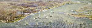
The peninsula was first cut by a storm in 1852, but a breakwater was built and the channel was filled in by silt. However, in 1858, the peninsula became an island permanently by a violent storm that cut a 500 feet (150 m) wide channel. The same storm destroyed two hotels on the island.[6]
_(14770718161).jpg)
After the peninsula became an island, the Hanlan family were among the first year-round inhabitants, settling at Gibraltar Point in 1862. In 1867 the City of Toronto acquired the islands from the federal government, and the land was divided into lots, allowing cottages, amusement areas and resort hotels to be built. The west side of the island became a resort destination for the people of Toronto and the first summer cottage community was built there. In 1878, a hotel was built by John Hanlan at the north-west tip of the island and soon after the area became known as Hanlan's Point. John's son, Edward "Ned" Hanlan, earned international recognition as a rower before taking over his father's business.[5] Other notable families on the islands include the Durnans (James James Durnan was the Gibraltar Point Lighthouse keeper in 1832) and Wards (David Ward settled on the eastern end in 1830).[10]
At the same time as Hanlan's Point was developing as a summer suburb of Toronto, developments were going on elsewhere on the islands. Along the lakefront of Centre Island, large Victorian summer homes were built by Toronto's leading families looking for refuge from the summer heat and drawn by the prestigious Royal Canadian Yacht Club, which had moved to a location on the harbour side of Centre Island in 1881. By contrast the Ward's Island community began in the 1880s as a tent community. William E. Ward built the Ward's Hotel and a few houses and rented tents to visitors. In 1888 the first year round public school was established on Centre Island at Gibraltar Point.
In 1899, there was a colony of eight summer tenants on Ward's Island paying $10 rent for the season.[11] By 1913, the number of tents pitched had increased to the point where the city felt it necessary to organize the community into streets, and the tents eventually evolved into a cottage community.[12][13]
In 1894, a land reclamation project by the Toronto Ferry Company created space for an amusement park at Hanlan's Point. In 1897, the Hanlan's Point Stadium was built alongside the amusement park for the Toronto Maple Leaf baseball team. The stadium was rebuilt several times over the years, and in 1914, Babe Ruth hit his first professional home run into the waters of Lake Ontario from this stadium. In the 1920s the Maple Leaf team moved to a new stadium on the mainland.
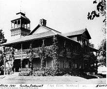
From 1915 to 1916 a temporary wooden hangar[14] was built at the beach by the Curtiss Flying School.[15] This floatplane aerodrome was used for flight training for World War I.
In 1937 construction started on a new airport on the site of the park and stadium.[5] The construction of the airport on infill led to the demolition of the stadium and most of the amusement park. It also meant that the cottage community at Hanlan's Point needed to be relocated. The residents were given the choice of either moving their cottages further south at Hanlan's Point or resettling on Algonquin Island. Originally, Algonquin Island was simply a sandbar known as Sunfish Island that was expanded by land reclamation operations. In 1938 streets were laid out to accommodate 31 cottages that were moved by barge from Hanlan's Point. The original aspect of Algonquin Island was of unvegetated sand, and the current lush environment of the island is the result of many years of work by residents.[12]
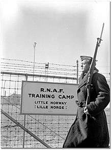
The airport opened in 1939, formally named the Port George VI Island Airport, after the reigning monarch of the time. During the first few years of the Second World War, expatriate Norwegian (RNAF) pilots-in-training used the Toronto Island Airport as a training field for both fighter and bomber pilots. Several accidents, including one where a pilot under instruction clipped the funnel and mast of the island ferry boat Sam McBride and crashed, led to the training school being moved north to Muskoka, Ontario. (The park on the mainland called Little Norway Park commemorates this period.)
At its peak in the 1950s, the Island residential community extended from Ward's Island to Hanlan's Point and was made up of some 630 cottages and homes, in addition to such amenities as a movie theatre, a bowling alley, stores, hotels, and dance halls.[16] Not long after its creation in 1953, Metropolitan Toronto Council undertook to remove the community and replace it with parkland.[17] The construction of the Gardiner Expressway had removed many acres of recreational land along the Toronto waterfront, and the Islands lands were to replace the acreage. In 1955, after the City had transferred the lands to Metro, the new Metro Parks Department started to demolish homes and cottages whose lease had expired or whose lease holders gave up their leases. In 1959, the Metro Parks Department opened 'Far Enough Farm', and in 1967, opened the Centreville Amusement Park, along with a new public marina. In 1971, Metro Parks opened a new ferry terminal at the foot of Bay Street. Unlike the previous terminal, no waiting room was provided.[18] In 1976, the Trillium, a 1910 paddle-wheeler ferry which had been abandoned in a lagoon, was refurbished and relaunched for use as an island ferry.
By 1963, all Islanders willing to leave the island had left and the remaining Islanders started to fight the plans of Metro to remove their homes. While demolitions still proceeded, the Islanders' alderman David Rotenberg pushed the Islanders' cause and the number of demolitions dwindled. In 1969, the Toronto Islands' Residents Association (TIRA) was formed. Still, by 1970 only 250 homes, on Ward's and Algonquin Islands, had escaped the bulldozer. The 1970s saw no further demolitions as the Metro Parks plans were thwarted by year-to-year leases and the changing of the guard on Toronto City Council to a group more sympathetic to the Islanders. In 1973, City Council voted 17–2 to preserve the community and transfer those lands back to the City. However, Metro Council remained opposed and the Islanders started legal challenges to Metro's plans in 1974 to delay Metro's plans of expropriation. By 1978, Metro Council had won several legal battles and had obtained 'writs of possession' for the 250 homes. At the time, a minority provincial Progressive Conservative government was in place with both the Liberals and NDP opposition parties in favour of the Islanders and the Islanders appealed to the provincial government, winning more time when the province agreed to act as mediator between the City and Islanders and Metro.[19]
Matters came to a head on July 28, 1980, when a sheriff sent to serve eviction notices to remaining residents was met at the Algonquin Island bridge by much of the community, whose leaders persuaded the sheriff to withdraw.[20] On July 31, the community won the right to challenge the 1974 evictions. The Islanders lost the challenge, but by this time, the province had started a formal inquiry headed by Barry Swadron into the Toronto Islands. On December 18, 1981, the province of Ontario passed a law legalizing the Islanders to stay until 2005. This kept the lands in Metro's ownership, to be leased to the City who would lease it to the Islanders.[21] Wrangling over the terms of the lease payments to Metro took several years.
The community's fight for survival was finally rewarded in 1993, when the Ontario Government passed the Toronto Islands Residential Community Stewardship Act, which enabled Islanders to purchase 99-year land leases from a Land Trust.[22]
In 2017, high lake levels flooded many park areas of the islands. The City of Toronto closed the islands to the public except for Ward's Island. Residents were able to remain through the use of sandbags to block the water. The Centreville amusement park could not open in May for the 2017 season and the animals at its farm were moved off the island.[23] The island parks will reopen on July 31, 2017, with a few areas still closed.[24] The amusement park also reopened but the farm was scheduled to remain closed for some months.[25][26] With a few exceptions, the Centreville amusement rides would be in operation, including a new version of its Sky Ride.[27] In July 2017, mosquitos carrying the West Nile virus were found on the islands but the Toronto Public Health Department said that with certain precautions, visitors should not be concerned.[28] The Island was selected for cycling events for the 2017 Invictus Games, but due to the flooding, the events were relocated to High Park.
Timeline
- 1787 – Toronto Purchase. The British and the Mississaugas negotiate the purchase of 250,800 acres (101,500 ha) of land north from Toronto Harbour.
- 1793 – Blockhouse built by the Queen's Rangers at Gibraltar Point.
- 1805 – The British and the Mississaugas renegotiate the Toronto Purchase.
- 1809 – Lighthouse constructed at Gibraltar Point.
- 1833 – First hotel "The Retreat on the Peninsula" is opened.[29]
- 1834 – Fisherman David Ward and family, along with shipbuilder John Hanlan are some of the first settlers on the island.
- 1830–1840 – First island hotels built. Ferry services are started.
- 1850 – Filtration plant on island starts supplying water to Toronto.
- 1855 – Rower Ned Hanlan born.
- 1858 – Storm separates Toronto Islands from the mainland. Quinn's Hotel and Parkinson's Hotel are destroyed.[30]
- 1867 – Islands become the property of City of Toronto. Lot leases are established.
- 1870–80 – Summer homes established on the island. Cottages from Hanlan's Point to Centre Island.
- 1874 – John Hanlan, father of Ned Hanlan opens Hanlan's Hotel.
- 1879–1912 – Size of islands increased to 563 acres (228 ha) by landfilling. This included the creation of Algonquin Island.[31]
- 1880 – Royal Canadian Yacht Club established on the island.
- 1882 – William Ward, son of David Ward opens Ward's Hotel; closed 1966.
- 1884 – St. Rita's and St. Andrew-on-the-Lake churches built.
- 1897 – First amusements on Hanlan's Point established by John Hanlan.
- 1897 – Baseball and lacrosse stadium on Hanlan's Point.
- 1899 – First summer colony established on Ward's.
- 1903 – Baseball stadium destroyed by fire and rebuilt.
- 1909 – Hanlan Hotel destroyed by fire.
- 1909 – Baseball stadium again destroyed by fire and rebuilt.
- 1910 – Ferry Trillium enters service to island
- 1913 – First 'tent city' on Ward's Island.
- 1914 – First professional home run of Babe Ruth's career hit at Hanlan's Point Stadium.
- 1916 – Area of Ward's Island doubled through dredging of the harbour.[31]
- 1926 – Baseball stadium vacated by Toronto Maple Leafs baseball team for a new stadium at foot of Bathurst and Fleet Streets.
- 1937 – Construction of Island airport begins. Some cottages moved east to Algonquin Island.
- 1939 – The Sam McBride ferry enters service.
- 1947 – City approves year-round residency to cope with a housing shortage.
- 1951 – Island Yacht Club established on Muggs Island.
- 1956 – New Metro Toronto government takes over Island and leases. Starts demolishing cottages.
- 1959 – Far Enough Farm opens.
- 1967 – Centreville Amusement Park opens.
- 1967 – Toronto Island Marina opens.
- 1975–1985 – Canadian Open Frisbee Championships, held at Olympic and Wards Island.[32] First ultimate games and disc golf competition in Canada.[33]
- 1977–1993 – Supreme Court approves of cancellation of leases by Metro. Remaining residents fight to remain.
- 1984 – Start of scheduled regional airlines at Island airport.[34]
- 1991 – Transfer of cottage lands and lease to City allowing residents to stay.
- 2002 – Council approves clothing optional Hanlan's Point Beach.
- 2010 – Canadian government and Mississaugas finalize settlement of outstanding disagreements over Toronto Purchase, including Toronto Islands.
- 2015 – Opening of the island airport pedestrian tunnel.
- 2017 – Water levels reach a record high of 75.919m above sea level (as of May 26), surpassing the 1973 record of 75.7m.[35] The Toronto Island Public School, Centreville Amusement Park, and public access to the park west of Ward's Island is suspended until further notice. Most of the Island Parks and the amusement park will reopen on July 31, 2017.
Source: Sward 1983[36]
Geography
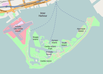
The area of the islands is about 820 acres (330 ha).[31] The largest, outermost island, called Centre Island, is crescent-shaped and forms the shoreline of both the Eastern and Western Channels. Algonquin (Sunfish Island) and Olympic are two of the other major islands. The former is mostly a residential area and the latter is parkland. Centre Island is home to the city's Island Public/Natural Science School. What is commonly called Ward's Island is actually the eastern end of Centre Island and like Algonquin is a residential area. The Centre Island dock and Centreville amusement park are located on Middle Island, which as a consequence, is often mistaken for Centre Island. Centre Island is sometimes referred to as Toronto Island (note the singular form) to prevent this type of confusion.[37] Other smaller islands include:
- Mugg's Island – home to the Island Yacht Club
- Forestry Island – heavily forested and no fixed link to other islands
- Snake Island – partially forest and beach facing Toronto Harbour (Snake Island Park); access from pedestrian bridge on south side to Centre Island
- South Chippewa Island – heavily forested and located between Snake Island and South Island
- South Island – used for mooring and on-land storage of boats by the Royal Canadian Yacht Club; east end of island cut off at Chippewa Avenue and covered by trees; a tennis court is located on west end of the island
- RCYC Island – occupied by Royal Canadian Yacht Club with clubhouse, moorings and other club facilities; private pier for RCYC launches Kwasind and Hiawatha to the mainland
Two unnamed islands occupy what was once Block House Bay:
- a small island (sometimes called Doughnut Island) in Long Pond (the former water intake of the City of Toronto) – located across from Mugg's Island; small sandbar allows boats to moor alongside
- small island in Lighthouse Pond sometimes called Hanlan's Island
The islands were originally a 9 kilometres (5.6 mi)-long peninsula or sand spit extending from the mainland. The islands are composed of alluvial deposits from the erosion of the Scarborough Bluffs. The flow from the Niagara River to the south across Lake Ontario causes a counter-clockwise east-to-west current which has, over time, deposited sediments at the south end of the harbour to form a sand spit.
In 1852, a storm flooded sand pits on the peninsula, creating a channel east of Ward's.[38] The channel was widened and made permanent by a violent storm in 1858. The channel became known as the Eastern Gap.[37][5] The peninsula to the west became known as the Toronto Islands. To the east of the Gap, the area of today's Cherry Beach was known as "Fisherman's Island".
Sediment deposition to the Islands halted in the 1960s when the Leslie Street Spit was extended beyond the southern edge of the islands. Left to nature, the islands would diminish over time, but this is limited due to hard shorelines built to limit erosion. Over the years land reclamation has contributed to an increase in the size of the islands. The harbour was shallow with a sandy bottom and the sands were moved by dredging or suction methods. Ward's Island was expanded by dredging. Today's Algonquin Island, formerly known as Sunfish Island, was created from harbour bottom sands.
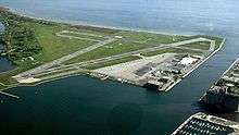
The area now occupied by the airport has been subject to several landfills over what was once sandy shoal, initially to accommodate the amusement park that preceded the airport, and then to accommodate the airport itself.[37][5] The Western Channel to the north of the airport is part of the original western channel, which was just south of today's Fort York. It was opened in 1911 as part of a program to improve boat navigation into the harbour. The airport lands were created from harbour sands in the late 1930s.
A series of waterways allow boat traffic to navigate the island:
- Allan Lamport Regatta Course – located between Centre Island and Middle Island from Long Pond to east end of Far Enough Farm
- Block House Bay – located on east side of Hanlan's Point
- Lighthouse Pond – located next to Gibratar Point lighthouse
- Long Pond – located between Allan Lamport Regatta Course and Block House Bay
- Snake Pond – located between Snug Harbour and Algonquin Island
- Snug Harbour – located between Snake Island and Olympic Island
- Trout Pond – located west of Lighthouse Bay on the south end of Hanlan's Point
Hanlan Bay was a waterway that has since been buried under the Toronto Island Airport runways.
.jpg)
Climate
The Toronto Island has a humid continental climate (Dfb) under the Köppen climate classification system.[39]
The climate differs from the mainland in that cooler lake waters surrounding the island cool spring, summer and early fall daytime temperatures by 2–3C, on average. In winter the unfrozen lake waters are sometimes warmer than the air, temperatures are roughly equivalent to the downtown area but warmer than areas further away from the lake. Fog and low-clouds are more frequent at the island than on the mainland. Near shore areas of the lake only freeze after a consistent period of sub-freezing weather.
The highest temperature ever recorded at Toronto Island was 37.2 °C (99.0 °F) on June 15, 1919.[40] The coldest temperature ever recorded was −30.0 °C (−22.0 °F) on January 13, 1914.[41]
| Climate data for Toronto Island Airport, 1981–2010 normals, extremes 1905–present | |||||||||||||
|---|---|---|---|---|---|---|---|---|---|---|---|---|---|
| Month | Jan | Feb | Mar | Apr | May | Jun | Jul | Aug | Sep | Oct | Nov | Dec | Year |
| Record high °C (°F) | 14.1 (57.4) |
18.5 (65.3) |
22.5 (72.5) |
30.1 (86.2) |
34.1 (93.4) |
37.2 (99) |
37.0 (98.6) |
36.1 (97) |
33.4 (92.1) |
30.8 (87.4) |
20.0 (68) |
17.3 (63.1) |
37.2 (99) |
| Average high °C (°F) | −0.8 (30.6) |
0.0 (32) |
3.8 (38.8) |
10.5 (50.9) |
16.6 (61.9) |
22.2 (72) |
25.5 (77.9) |
24.5 (76.1) |
20.1 (68.2) |
13.3 (55.9) |
7.6 (45.7) |
1.9 (35.4) |
12.1 (53.8) |
| Daily mean °C (°F) | −4.0 (24.8) |
−3.3 (26.1) |
0.5 (32.9) |
6.8 (44.2) |
12.4 (54.3) |
17.8 (64) |
21.1 (70) |
20.7 (69.3) |
16.4 (61.5) |
10.0 (50) |
4.8 (40.6) |
−1.0 (30.2) |
8.5 (47.3) |
| Average low °C (°F) | −7.3 (18.9) |
−6.5 (20.3) |
−2.9 (26.8) |
3.0 (37.4) |
8.1 (46.6) |
13.2 (55.8) |
16.7 (62.1) |
16.8 (62.2) |
12.6 (54.7) |
6.6 (43.9) |
1.8 (35.2) |
−3.9 (25) |
4.8 (40.6) |
| Record low °C (°F) | −30.0 (−22) |
−29.4 (−20.9) |
−23.1 (−9.6) |
−13.3 (8.1) |
−3.3 (26.1) |
2.2 (36) |
4.4 (39.9) |
5.0 (41) |
1.7 (35.1) |
−5.0 (23) |
−13.9 (7) |
−27.2 (−17) |
−30.0 (−22) |
| Average precipitation mm (inches) | 45.3 (1.783) |
48.6 (1.913) |
54.8 (2.157) |
63.9 (2.516) |
75.0 (2.953) |
62.7 (2.469) |
65.0 (2.559) |
84.8 (3.339) |
86.3 (3.398) |
67.1 (2.642) |
83.4 (3.283) |
60.4 (2.378) |
797.3 (31.39) |
| Average rainfall mm (inches) | 19.5 (0.768) |
23.0 (0.906) |
39.6 (1.559) |
61.5 (2.421) |
75.0 (2.953) |
62.7 (2.469) |
65.0 (2.559) |
84.8 (3.339) |
86.3 (3.398) |
67.1 (2.642) |
78.5 (3.091) |
41.1 (1.618) |
704.0 (27.717) |
| Average snowfall cm (inches) | 28.1 (11.06) |
26.3 (10.35) |
15.5 (6.1) |
2.7 (1.06) |
0.0 (0) |
0.0 (0) |
0.0 (0) |
0.0 (0) |
0.0 (0) |
0.03 (0.012) |
4.8 (1.89) |
19.7 (7.76) |
97.1 (38.23) |
| Average precipitation days (≥ 0.2 mm) | 13.9 | 11.6 | 11.7 | 12.7 | 12.3 | 10.7 | 10.3 | 10.9 | 11.4 | 12.3 | 13.4 | 13.0 | 144.2 |
| Average rainy days (≥ 0.2 mm) | 4.4 | 5.1 | 8.4 | 11.8 | 12.3 | 10.7 | 10.3 | 10.9 | 11.4 | 12.3 | 12.0 | 7.4 | 117.0 |
| Average snowy days (≥ 0.2 cm) | 10.5 | 8.3 | 5.3 | 1.6 | 0.0 | 0.0 | 0.0 | 0.0 | 0.0 | 0.07 | 2.4 | 7.7 | 35.6 |
| Source: Environment Canada[40][41][42][43][44][45][46][47] | |||||||||||||
Culture
Community
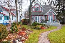
A community of about 300 homes is located on the Toronto Islands, concentrated at the eastern end of the island chain on Ward's Island and Algonquin Island. Under the terms of the Toronto Islands Residential Community Stewardship Act there are strict rules under provincial law governing the buying and selling of these homes.[12][22]
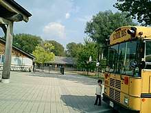
There are two daycare centres, one school and one church on the islands. The Toronto Island Public School (30 Centre Island Park), a public school located at Gibraltar Point, operates a day programme for island residents, residents of the Toronto waterfront and other students that can apply for enrollment, up to grade 6, a residential natural science programme for visiting grade 5/6 students from the mainland, and a pre-school nursery. The Waterfront Montessori Children's Centre (18 Wyandot Avenue), a non-profit, parent run co-operative pre-school nursery for children aged 2½ to 5, is located on Algonquin Island. St. Andrew-by-the-Lake Church (102 Lakeshore Avenue) is an Anglican church located on Centre Island which serves the islands' residents and visitors.[48][49][50][51] The semi-Gothic/Medieval/Stick Style building was built in 1884.[52]
The Ward's Island residential community encompasses 12 acres (5 ha) of the entire 820-acre (330 ha) Toronto Island park. There are approximately 150 residences, most of which are occupied on a yearly basis and a centrally located Ward's Island Association club house which was built 1937-8. The layout of the streets remains as it has been since 1915 and the streets are named sequentially First, Second, Third, Fourth, Fifth, Sixth Streets, as well as Bayview, Willow, Channel, Lenore and Lakeshore Avenues and Withrow Street.[53]
Artscape Gibraltar Point (formerly The Gibraltar Point Centre for the Arts) occupies buildings previously used by the Toronto Island Public School, and comprises more than 15 artist work studios occupied by a mix of painters, ceramists, sculptors, musicians, theatre companies, and a recording studio. The centre provides a long and short-term studio and bedroom rental service for artists, together with meeting, conference and special event services and an artist residency program.[54]
Recreation
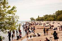
There are several swimming beaches on the islands, including Centre Island Beach, Manitou Beach, Gibraltar Point Beach, Hanlan's Point Beach and Ward's Island Beach. Hanlan's Point Beach includes an officially recognized clothing optional section.[55] Ward's Island Beach is located on the island east end near the Eastern Gap.[56] Island Beach is located on the south side of the island and faces out to Lake Ontario. The beach is actually two beaches with the portion west of the Lookout Pier called Manitou Beach. The eastern boundary is near the western end of the boardwalk from Ward's Island. Hanlan's Point Beach is located on the west side of Toronto Islands on Lake Ontario, south of the airport and Hanlan's Point ferry dock.
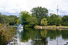
Recreational boating has been popular on the islands for over a century. The Islands are home to four yacht clubs: Harbour City Yacht Club, Island Yacht Club, Queen City Yacht Club and the Royal Canadian Yacht Club. There is a public marina, the Toronto Island Marina, and several smaller clubs including the Toronto Island Sailing Club, the Sunfish Cut Boat Club and the Toronto Island Canoe Club. There is also a dragon boat regatta course and grandstand, where the Toronto International Dragon Boat Race Festival is held annually.[5] Canoes, kayaks and paddle boat are available for rental.
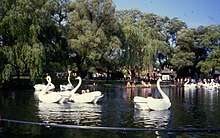
The central area hosts Centreville, a children's amusement park which was built in 1967 with a 1900s-style turn-of-the-century theme. The park includes a miniature railway and an antique carousel and is open daily in summer. The Far Enough Farm is nearby and displays common farm livestock and birds.[5] The Franklin's Garden children's garden was created in the 2000s and is located to the west of the Avenue of the Islands. A splash pad and playground is also located nearby.[57]
On the western side of Ward's Island is a flying disc golf course. There are public tennis courts located at Hanlan's Point and a community tennis club at the Ward's Island Tennis Club.
Until 2007 the Caribana held an annual arts festival at Olympic Island on the Simcoe Day weekend. Other Island events include the Olympic Island Festival, an annual rock concert held from 2004 until 2010. It was initiated in 2004 by Sloan's Jay Ferguson. The Wakestock festival has also been held on the islands. Starting in 1975, the Canadian Open Frisbee Championships were held on Olympic and Wards Island.[58]
Education
The Toronto District School Board (TDSB) is an English secular public school board that presently serves the City of Toronto, including the Toronto Islands. Presently the school board operates one elementary school on the Islands, Island Public/Natural Science School on Centre Island. As of 2013 the school has 179 students. 15% of the student population originates from Algonquin and Ward islands and about 85% of the students live in the city and take ferry transportation to school.[59]
Other TDSB schools attended by students that live on the Island include The Waterfront School, Jarvis Collegiate Institute, Central Technical School, Central Commerce Collegiate Institute, and Northern Secondary School.[60] However these schools are located on the mainland.
In addition to the Toronto District School Board, three other public school boards also operate in the city. The Toronto Catholic District School Board (TCDSB), is a public English separate school board; Conseil scolaire Viamonde is a secular French public school board; and the Conseil scolaire de district catholique Centre-Sud is a French separate public school board. However, none of the three school boards operate a school on the Toronto Islands.
Politics
The islands are part of Toronto Ward 28 Toronto Centre—Rosedale. The area was once part of St. Andrew Ward and Metro Toronto Ward 20 Trinity-Niagara. The islands have been part of the provincial riding of Trinity—Spadina since 2007 and are represented by Liberal MPP Han Dong. From 1999 to 2007 the area was part of Toronto Centre—Rosedale, and from 1987 to 1999 it was part of Fort York. The islands have been part of the federal riding of Trinity—Spadina since 2004 and are represented by Liberal MP Adam Vaughan who was elected in the 2014 by-election following the resignation of NDP MP Olivia Chow to run for the mayoral office. From 1997 to 2004 the area was part of Toronto Centre—Rosedale, from 1966 to 1997 it was part of Rosedale, from 1933 to 1966 it was part of Spadina and from 1903 to 1933 it was part of Toronto South.
Transportation
Airport
The north-western tip of the Toronto Islands is home to the Billy Bishop Toronto City Airport, more often known as the Toronto Island Airport. The airport is used for civil aviation, including airlines, flight training, medevac flights and private aviation. Since 1984, it has been used for regional airlines using approved STOL-type aircraft. In recent years, the airport has become the centre of controversy between those who wish to close it down, and those who want to expand its usage. One focus of this controversy had been a plan to construct a road bridge to the airport; this was a major issue in the 2003 election for mayor and was cancelled by Toronto City Council after David Miller became mayor. A pedestrian tunnel to the airport was opened in July 2015.[61] A proposal to allow jets at the airport was turned down by the Government of Canada.
Ferry services
There is no fixed road link from the mainland to the Toronto Islands, which therefore rely on ferries, water taxis and other boats for their transport needs.
Three public ferry routes provide links for passengers (both visitors and island residents) and service vehicles from the Jack Layton Ferry Terminal on the central Toronto waterfront to docks at Hanlan's Point, Centre Island Park and Ward's Island. A fourth public ferry service provides a vehicle and passenger connection from a dock at the foot of Bathurst Street to the airport. There is no public access between the airport and the rest of the island chain.
In addition to the public ferry services, several yacht clubs and marinas located on the islands provide private ferry services for their members and guests. In June 2017, Centreville purchased a used ferry boat, the Dartmouth III, from Halifax Transit in Nova Scotia and planned to operate its own service, Toronto Island Transit Service, will operate the ferry to the amusement park in peak season (supplementing the public ferry), though probably not until 2018.[62][63]
Roads
All roads on the islands are paved, the only exception being a long wooden boardwalk on the south end of Ward's Island. The use of motor vehicles is limited to City of Toronto service vehicles (Parks and Recreation, paramedics etc.). Bicycles are welcome on the ferries and the island, and there are rental bikes available on the island. Lakeshore Avenue is the main road handling vehicular traffic. The single lane paved road traverses the east, south and west sides of the park. The six bridges on the island are for pedestrian traffic, bicycles and all-terrain vehicles only. The bridge carrying traffic from Avenue of the Islands can support large vehicles, but not cars or heavy trucks. Other bridges include:
- two bridges connecting Centre Island with Olympic Island
- bridge along Chippewa Avenue to South Island
- bridge over to Snake Island
- Algonquin Road Bridge to Algonquin Island
The Island Bus provides shuttle service between Ward's Island and the Island Airport, mainly for the use of Island residents and Parks employees. It ran every two hours. The schedule has plenty of recovery time as the route crosses the live runway of the airport. Each crossing has to be accompanied by an escort.[64] Two Toronto Transit Commission (TTC) GM TC40-102N buses provided service to the Toronto Parks Department for use on the Island during the 1970s. Since they were withdrawn it has become usual for TTC to assign to the Island a bus from a series that is coming to the end of its service life. Thus more recently an obsolescent GM New Look operated on the Island until Spring 2012 after its regular service ended. Now that all TTC's 7000 series Orion V buses are retired except one (#7106)that survives on Toronto Island.
There are fewer restrictions on motor vehicles on the airport lands, with a vehicular ferry providing access to parking lots and service access at the airport, however there is no public road access from the airport lands to the rest of the islands.
In popular culture
The Toronto Islands have appeared as significant settings in Canadian literature. Examples include Margaret Atwood's The Robber Bride and Robert Rotenberg's Old City Hall.
In Take This Waltz, a 2011 film by Canadian director Sarah Polley, the main character Margot (Michelle Williams) rides the Scrambler at the Centreville Amusement Park.
The second season of Sensitive Skin is set predominantly on the islands when the main character, Davina moves to a houseboat located on the islands.
Notable people
- Ned Hanlan – Olympic rower
- Sam McBride – Toronto mayor
- Paul Henderson - sailor[65]
- Terry McLaughlin – Olympic sailor[66]
- John Millen – Olympic sailor [67]
References
- ↑ "Toronto Historic Maps". peoplemaps.esri.com.
- ↑ "First Peoples of Canada-Naming the land". Canadian Museum of History. Canadian Museum of History. Retrieved October 6, 2015.
- ↑ Smith, Donald B. (1987). Sacred Feathers. University of Toronto Press. p. 21. ISBN 0-8020-6732-8.
- ↑ "Fact Sheet – The Brant tract and the Toronto Purchase specific claims". Government of Canada. September 15, 2010. Archived from the original on April 15, 2013. Retrieved April 29, 2013.
- 1 2 3 4 5 6 7 "Toronto Island Park". City of Toronto. Retrieved March 26, 2008.
- 1 2 Toronto Harbour Commission Public Affairs Department 1985, p. 107.
- ↑ Sward 1983, p. 48.
- ↑ "Gibraltar Point Lighthouse". City of Toronto. Retrieved March 26, 2008.
- ↑ O'Keeffe, Eamonn (December 2015). "New Light on Toronto's Oldest Cold Case: The 1815 Murder of John Paul Radelmüller". Toronto: The Fife and Drum: 3–5.
- ↑ Infantry, Ashante (June 2, 2003). "Bill Durnan, 87, fixture on the Toronto Islands". The Star.
- ↑ "Ward's Island". Toronto Star. July 3, 1983. p. A13.
- 1 2 3 "The Place of My Dreams". Toronto Island Community. Retrieved March 26, 2008.
- ↑ "Our Heritage". Royal Canadian Yacht Club. Archived from the original on February 29, 2008. Retrieved March 26, 2008.
- ↑ See image at Aviation Technomuses
- ↑ Chen, Liwen. "Canada's First Aerodrome: Long Branch Curtiss Aviation School" (PDF) (pdf). Heritage Mississauga.
- ↑ "Toronto Islands Community web site".
- ↑ Gibson 1984, pp. 236-250.
- ↑ Gibson 1984, p. 271.
- ↑ Gibson 1984, pp. 254-288.
- ↑ Gibson 1984, pp. 290-291.
- ↑ Gibson 1984, p. 293.
- 1 2 "Toronto Islands Residential Community Stewardship Act, 1993". Government of Ontario. Retrieved February 19, 2008.
- ↑ "An eerie silence at Centreville". Toronto Sun. July 3, 2017.
- ↑ "Toronto Islands set to reopen after severe spring flooding" – via The Globe and Mail.
- ↑ Rizza, Alanna (July 27, 2017). "Toronto Islands will reopen on Monday, city confirms" – via Toronto Star.
- ↑ "An eerie silence at Centreville".
- ↑ "After massive effort, Toronto Island ready to re-open - Metro Toronto".
- ↑ Hudes, Sammy (July 26, 2017). "Mosquitoes with West Nile virus found on Toronto Islands" – via Toronto Star.
- ↑ Toronto Harbour Commission Public Affairs Department 1985, p. 113.
- ↑ Toronto Harbour Commission Public Affairs Department 1985, p. 114.
- 1 2 3 Toronto Harbour Commission Public Affairs Department 1985, p. 112.
- ↑ "TUC Hall of Fame Ken Westerfield". Toronto Ultimate Club. Retrieved October 22, 2014.
- ↑ "History of Frisbee and Flying Disc freestyle". Development of Frisbee in Canada. Retrieved June 26, 2018.
- ↑ Harding, Katherine (July 26, 2001). "Group urges turning airport to park". Toronto Star. p. B07.
- ↑ "Government of Canada Tidal Observations for May 2017".
- ↑ Sward 1983, pp. xv, 42–51.
- 1 2 3 Kidd, Joanna. "Nature on the Toronto Islands: An Explorer's Guide" (PDF). City of Toronto. Archived from the original (PDF) on April 11, 2008. Retrieved March 26, 2008.
- ↑ Wickson 2002, p. 30.
- ↑ "Climate Toronto: Temperature, Climograph, Climate table for Toronto - Climate-Data.org". en.climate-data.org.
- 1 2 "Daily Data Report for June 1919". Canadian Climate Data. Environment Canada. Retrieved July 23, 2016.
- 1 2 "Daily Data Report for January 1914". Canadian Climate Data. Environment Canada. Retrieved July 23, 2016.
- ↑ "Toronto Island A". Canadian Climate Normals 1981–2010. Environment Canada. Retrieved November 21, 2013.
- ↑ "Toronto Island". Canadian Climate Data. Environment Canada. Retrieved July 23, 2016.
- ↑ "Toronto Island A". Canadian Climate Data. Environment Canada. Retrieved July 23, 2016.
- ↑ "Toronto City Centre". Canadian Climate Data. Environment Canada. Retrieved July 23, 2016.
- ↑ "Toronto City Centre". Canadian Climate Data. Environment Canada. Retrieved July 23, 2016.
- ↑ "Daily Data Report for February 2017". Canadian Climate Data. Environment Canada. Retrieved February 25, 2017.
- ↑ "Toronto Island Public School". Toronto Island Public School. Retrieved March 28, 2008.
- ↑ "Gibraltar Point Day Nursery". Gibraltar Point Day Nursery. Retrieved March 28, 2010.
- ↑ "Waterfront Montessori Daycare". Canadian Council of Montessori Administrators. Retrieved March 28, 2008.
- ↑ "St. Andrew-by-the-Lake Anglican Church". Toronto Island Community. Retrieved March 28, 2008.
- ↑ "History - St. Andrew by-the-Lake Anglican Church - Toronto Island". St. Andrew by-the-Lake Anglican Church - Toronto Island. Retrieved July 11, 2017.
- ↑ "WARD'S ISLAND A COMMUNITY WORTH SAVING" Thesis by Alison Suki Suzanne Katherine Diamond, University of Pennsylvania, 1994
- ↑ "Gibraltar Point Centre for the Arts". Artscape. Retrieved May 2, 2010.
- ↑ "Toronto Blue Flag Beaches". Tourism Toronto. Retrieved March 28, 2008.
- ↑ "What to do on Toronto Islands". Guided Toronto. July 1, 2018.
- ↑ "How to Spend a Day on the Toronto Island With Kids - Help! We've Got Kids". Help! We've Got Kids. May 22, 2016. Retrieved June 15, 2018.
- ↑ "TUC History". Retrieved December 12, 2014.
- ↑ "Home." (Archive) Island Public/Natural Science School. Retrieved on October 1, 2013.
- ↑ "Find your school by address." Toronto District School Board. Retrieved on October 2, 2013. Enter "Centre Island" to get information
- ↑ "Innovative New Airport Pedestrian Tunnel a Boost for Passengers and Toronto Economy" (PDF). Toronto Port Authority. March 9, 2012.
- ↑ Isai, Vjosa (July 7, 2017). "Toronto is getting a new ferry" – via Toronto Star.
- ↑ "Dartmouth ferry set to make slow, long journey to Toronto".
- ↑ Buses Worldwide magazine May 2015 ISSN 0961-2122
- ↑ "The “Pope” of Sailing – Paul Henderson, speaker at the Whiff of Grape, January 27, 2015 http://whiff-of-grape.ca/the-pope-of-sailing-paul-henderson/
- ↑ "CBC Sports - Sporting news, opinion, scores, standings, schedules". panam.cbc.ca.
- ↑ Toronto sailors finish fifth in world championship, Toronto Star, July 22, 1988, Mary Haynes, Sports Section page G2 http://pqasb.pqarchiver.com/thestar/doc/435751665.html?FMT=ABS&FMTS=ABS:FT&type=current&date=Jul+10%2C+1988&author=&pub=Toronto+Star&edition=&startpage=G.2&desc=Toronto+sailors+finish+fifth+in+world+championship
Bibliography
- Gibson, Sally (1984). More Than an Island. Toronto: Irwin Publishing. ISBN 0-7720-1446-9.
- Rosenbaum, Linda; Dean, Peter (2004). The Essential Toronto Island Guide. Toronto: Island Ad/Ventures. ISBN 0-9735855-0-1.
- Swadron, Barry B. (1981). Pressure Island: The Report of the Commission of Inquiry into the Toronto Islands. Government of Ontario.
- Sward, Robert (1983). The Toronto Islands. Toronto, Ontario: Dreadnought. ISBN 0-919567-22-3.
- Toronto Harbour Commission Public Affairs Department (1985). Toronto Harbour – The Passing Years. Toronto, Ontario: Toronto Harbour Commissioners.
- Wickson, Ted (2002). Reflections of Toronto Harbour. Toronto, Ontario: Toronto Port Authority. ISBN 0973000201.
Further reading
- "Toronto Island school is vital." (letter) Toronto Star. June 29, 1992. LETTER section.
- Jones, Frank. "Toronto Island School revisited." Toronto Star. May 17, 1998. LIFE p. E1.
External links
| Wikimedia Commons has media related to Toronto Islands. |
| Wikivoyage has a travel guide for Toronto Islands. |
- City of Toronto website about the Islands
- Toronto Island community website
- Toronto Islands historical plaque
Places adjacent to Toronto Islands | ||||||||||
|---|---|---|---|---|---|---|---|---|---|---|
| ||||||||||
| Features | |||||||
|---|---|---|---|---|---|---|---|
| History |
| ||||||
| Geography | |||||||
| Economy | |||||||
| Politics |
| ||||||
| Public services | |||||||
| Education |
| ||||||
| Culture |
| ||||||
| Transportation |
| ||||||
| |||||||
Coordinates: 43°37′15″N 79°22′43″W / 43.62083°N 79.37861°W