Scarborough City Centre
| Scarborough City Centre | |
|---|---|
| Neighbourhood | |
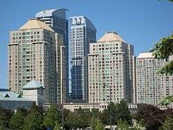 High rise buildings at Scarborough City Centre as viewed from the intersection of Highway 401 and Neilson Road | |
 | |
| Coordinates: 43°46′22″N 79°15′27″W / 43.77278°N 79.25750°WCoordinates: 43°46′22″N 79°15′27″W / 43.77278°N 79.25750°W | |
| Country |
|
| Province |
|
| City |
|
| Community | Scarborough |
| Changed Municipality |
1998 Toronto from |
| Government | |
| • MP | Salma Zahid (Scarborough Centre) |
| • MPP | Brad Duguid (Scarborough Centre) |
| • Councillor | Glenn De Baeremaeker (Ward 38 Scarborough Centre) |
Scarborough City Centre is a commercial district in Toronto, Ontario, Canada. Once considered the city centre for the former city of Scarborough, which was amalgamated with the rest of Toronto in 1998, the city centre remains as one of the major business districts outside Downtown Toronto.
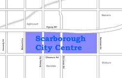
It is roughly bounded by Kennedy Road to the west, Markham Road to the east, Ellesmere Road to the south, and Sheppard Avenue to the North, spanning the official neighbourhoods of Bendale, Agincourt, and Woburn. At its core is the Scarborough Civic Centre, Albert Campbell Square, Scarborough Town Centre shopping mall, and the Canada Centre Building. The district is connected to public transit services at Scarborough Centre station by local buses and Line 3 Scarborough trains operated by the Toronto Transit Commission (TTC). Regional and intercity bus services stop at the adjacent Scarborough Centre Bus Terminal.
Condominium towers surround these central buildings and public spaces, forming the skyline. The major office towers in the area are those at Consilium Place, which was completed in 1991. In a band around the southern side of the city centre are densely forested parklands, between Borough Drive and Ellesmere Road. Outside the immediate city centre is mostly industrial parks and low-density housing.
History
Prior to the 1940s, the area was mainly agricultural and the closest communities were Agincourt and Malvern. One farm was the farm of George and Lena Bick, who founded the Bick's Pickle brand from pickles grown and processed on their farm. Although the farm was eventually converted to residential and industrial land, the production facility was located on Progress Avenue until 2001.[1] Development in the area had first come in the 1950s when Ontario Highway 401 was built through the area. One early development was the TV studios of CFTO-TV at the intersection of the 401 and McCowan Road.
Scarborough became part of Metropolitan Toronto in 1954. As part of the new regional municipal government’s planning policy, plans were put forth to develop the city centres of municipalities surrounding Downtown Toronto. Scarborough Civic Centre, which was built to house the Scarborough municipal and Metropolitan Toronto offices, and the Scarborough Town Centre were built in the 1970s. The Scarborough RT was completed in 1985. The beginning of the 21st century saw the completion of several condominium skyscrapers and office complexes in the area.
References
- ↑ "Bick's Pickles". cooksinfo.com.
Places adjacent to Scarborough City Centre | ||||||||||
|---|---|---|---|---|---|---|---|---|---|---|
| ||||||||||