Weston, Toronto
| Weston | |
|---|---|
| Neighbourhood | |
 Weston Road at John | |
 | |
 Location within Toronto | |
| Coordinates: 43°42′3.56″N 79°31′10.92″W / 43.7009889°N 79.5197000°WCoordinates: 43°42′3.56″N 79°31′10.92″W / 43.7009889°N 79.5197000°W | |
| Country |
|
| Province |
|
| City |
|
| Community | York |
| Settled | c. 1790s |
| Incorporated |
1881 (Village) 1914 (Town) |
| Changed Municipality |
1954 1998 Toronto from York |
| Annexed | 1967 into York |
| Government | |
| • MP | Ahmed Hussen (York South—Weston) |
| • MPP | Laura Albanese (York South—Weston) |
| • Councillor | Frances Nunziata (Ward 11 York South-Weston) |
| Population (2006)[1] | |
| • Total | 16,470 |
| Website | welcometoweston.ca |
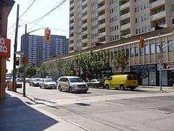
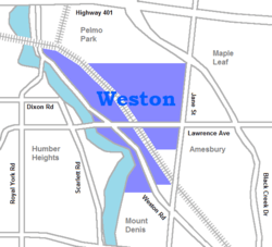
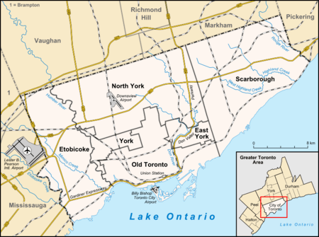
Weston is a neighbourhood and former village in Toronto, Ontario, Canada. The neighbourhood is situated in the northwest of the city, south of Highway 401, east of the Humber River, north of Eglinton Avenue, and west of Jane Street.[2] Weston Road just north of Lawrence Avenue is the commercial core of Weston, with many small businesses and services. Weston was incorporated as a village in the 19th century and was absorbed into the Borough of York in the late 1960s. York itself was amalgamated into Toronto in 1998.
Description
Weston's building stock consists mostly of Victorian homes east of the railway with apartment and condominium towers on Weston Road overlooking the Humber River valley. Weston's main shopping district is located on Weston Road between Church Street in the north and Wilby Crescent (just south of Lawrence Avenue) in the south. Most buildings in this area reflect early-mid-20th century Ontario town architecture, brick buildings with decorative masonry. The area has a noteworthy library (previously a Mechanics' Institute and Carnegie library). The community is dotted with grand old churches with architectural significance. There has been a recent move in Weston to designate certain areas as a historical district.[3]
Most streets in Weston are lined with tall mature trees, some well over 100 years old. This is more common east of the railway tracks. Recently, there has been some infill development on former industrial and commercial lands bringing some new housing stock to the area. On April 26, 2013, a fire was accidentally started at 2304 Weston Road, due to tar during roof construction.
History
The first European settlement in the Weston area took place in the 1790s, when a saw mill was built in Etobicoke Township on an old native trading path along the west side of the Humber River, named after the well-known Humber estuary in Yorkshire, England. In 1815 James Farr, a prominent local mill owner, named the growing settlement "Weston" after his birthplace, Weston, Hertfordshire. Weston initially developed along both sides of the river until a disastrous flood in 1850 destroyed the west bank settlement.[4] The former west bank settlement is now the site of the Weston Golf and Country Club.[5] Improvements to the Main Street, now Weston Road, and the 1856 arrival of the Grand Trunk Railway brought growth on the east side.[4]
The first post office was opened in 1842. The first library opened in 1858, a Mechanic's Institute. In 1865, the Trinity College School opened, founded by William Arthur Johnson. It was located in Weston near the old Mill and at a home further north until 1867. It relocated to Port Hope, Ontario in 1868.
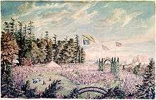
A second railway company arrived in 1869. On October 5, 1869, Prince Arthur, Duke of Connaught and Strathearn attended the sod turning ceremony for the construction of the Toronto, Grey and Bruce Railway. The spade which he used for the event is kept in the public library.
The town of Weston grew, and over the 19th century became an important industrial centre for the Toronto area. The symbol adopted for the town, an outline of an old-fashioned bicycle, was based on this history of manufacturing and especially the old CCM bicycle factory on Lawrence Avenue just east of Weston Road. Models of bicycles now hang from the streetlights along Weston Road.
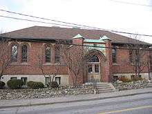
Weston was incorporated as a village in 1881, and then as a town in 1914. In 1914, the town also saw the opening of Weston Public Library, a Carnegie library. This building is now recognized with heritage status.
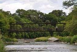
In October 1954, Hurricane Hazel flooded the Humber River valley, causing death and destruction of property.[5] In response, low-lying areas in the Humber River valley were converted to parkland and property zoning standards were changed across Ontario to avoid building encroachment on floodplains. There is a memorial in the south end of Lions Park near a pedestrian bridge which incorporates the original footing of a bridge that once crossed the Humber. The other footing of the bridge is the square chunk of concrete that is in the middle of the river nearby.
In 1967, it became part of the Borough (later City) of York. In 1998, York was in turn amalgamated with the five other members of Metropolitan Toronto, (Toronto, Etobicoke, North York, East York, and Scarborough) in the new "megacity" of Toronto. Vocal lobbying at the time allowed Weston to retain many street names which are exact duplicates of downtown streets, including Church Street, King Street and John Street.
Airport link controversy
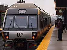
The Union Pearson Express between Toronto Pearson International Airport and Union Station downtown was a hot political issue in Weston. It had originally been proposed for completion by 2009. Weston is currently a station stop on the Kitchener line operated by GO Transit and additional airport trains would stop there. The link would see the construction of three additional tracks through the neighbourhood and increased rail traffic more than fourfold. Community activists worried about how the link would sever the community (vehicle traffic on one street will be permanently blocked from crossing the tracks, replaced by a pedestrian bridge) and the possibility of lower future property values due to increased noise and diesel fumes.
It was an issue during the Canadian federal election held on January 23, 2006, when incumbent Liberal Member of Parliament, Alan Tonks, supported the link, while the other candidates opposed it. It was also an issue in the February 2007 provincial by-election, where all local candidates came out against the link, but which was still supported by the governing Liberals. The Weston Community Coalition (WCC) had proposed a subway line as an alternative to run through the Weston rail corridor to the airport that would have stops along the way which would serve many communities throughout Toronto and be operated by the TTC rather than a private company. Various other alternatives were presented by community activists such as an Eglinton subway to the airport, an LRT alternative, or a route down Highway 427.
In the end, the tracks went into a trench with bridges overhead to prevent bisecting the neighbourhood.[6] A "rail deck park" allowed the expansion of a Toronto Catholic school playground over the tracks.[7]
Demographics
Information regarding ethnicity is collected via the long form of the Canadian census distributed to 20% of the respondents. The total population dwellings for the year 2006, was 6,791, however, in the year 2011, the total population in the Weston and Lawrence neighborhood increased to 7,988 people (Statistics Canada, 2006 & 2011). One argument brought up by Rummens (2014), is that the ethnic origin question emerges as a key anchor for obtaining public knowledge regarding Canadian diversity and the changing demographics of the country over time (p. 1). Interesting to note, is the total number of people who identify as persons of Somali origin compared to the total population located in census tract 5350175.02 in the year 2006 and 2011. According to Statistics Canada, there were 250 people who identified as persons of Somali origin out of the total population of 6,791 people. Conversely, in the year 2011, 40 more persons identified as persons of Somali origin, this increased the total number of Somali people to 290 while the population raised to 7,998 an upsurge of 1,207 people in census tract 5350175.02 (Statistics Canada, 2006 & 2011).
Public transportation
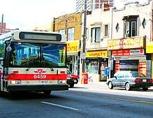
Weston falls within the service area of the Toronto Transit Commission (TTC). Transit is provided entirely by buses linking to the subway system. The 32 Eglinton West,[8] 35 Jane,[9] 52 Lawrence,[10] 59 Maple Leaf,[11] 73 Royal York,[12] 79 Scarlett,[13] and 89 Weston[14] all pass through the boundaries of Weston.
As of January 2012,[15] all TTC bus routes serving Weston are accessible. Routes 52 and 352 were the final TTC bus routes to be made accessible, with the retirement of the last GMC New Look "Fishbowl" buses in December 2011. Although all bus routes are accessible, individual stops along the routes may not meet accessibility standards.
The Metrolinx Weston GO Station is located at Weston Road and Lawrence Avenue. The station is served by the Kitchener line (which connects Kitchener, Ontario to downtown Toronto during rush hours) and the Union Pearson Express (all-day service between Toronto Pearson International Airport and downtown Toronto). The Weston GO Station is wheelchair accessible.
Recreation
The Weston Farmers' Market opens weekly from mid-May to the end of October near the centre of Weston.[16] The Weston BIA also hosts a Harvest Festival around Thanksgiving in October, and the Weston Santa Claus Parade each November.[17]
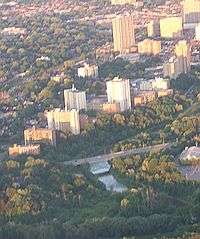
Weston has many small parks throughout but most notable is Cruickshank Park in the Humber River valley with many mature trees and paved bicycle paths[18] lined with large weeping willow trees. The bicycle path continues south to Lake Ontario. Sometimes salmon can be seen swimming upstream in the river. The park has a population of beaver as can be seen from the tell-tale marks left behind on trees. In order to protect some trees, park staff have wrapped the tree trunks with wire screen in some areas. There are also some frogs closer to the water's edge and garter snakes hidden away in the more secluded areas. Canada geese, loons, mallards and seagulls are a common sight. Herons have also been spotted looking for fish in the river. In some areas of the park, you can see exposed sedimentary rock in the walls of the valley, made visible by the action of glaciers that carved out the valley during the last glacial period about 20,000 years ago. The same rock was used to build many stone retaining walls throughout the town; an example of this use can be seen on the south end of the Lawrence Avenue bridge in the north end of Lions Park.
Weston Lions Park, located south of Lawrence Avenue, fills 22.13 acres (89,600 m2) and contains facilities for playing football, rugby union, soccer, tennis, and baseball, as well as an ice rink, swimming pool, basketball court and skatepark.[19]
Mayors of the Town of Weston
- 1914-1918 Dr. W. J. Charlton
- 1919-1920 John Gardhouse
- 1921-1925 Robert John Flynn
- 1926-1928 George Sainsbury
- 1929-1930 A. Lorne Coulter
- 1931 W. J. Pollett
- 1932-1934 Sam J. Totten
- 1935-1936 Frank Walton Mertens
- 1937-1939 George Benjamin Evans
- 1940-1942 Gordon S. Harris
- 1942-1945 John P. Allan
- 1946-1948 Thomas Dougherty
- 1949 Kenneth L. Thompson
- 1950-1954 Richard C. Seagrave
- 1955-1958 Harry Clark
- 1959-1960 Jack L. Holley
- 1961-1964 George W. Bull
- 1965-1966 Wesley Boddington
Notable residents
- Jason Allison, professional ice hockey player; attended Emery Collegiate in Weston
- Dalbello, recording artist, songwriter, multi-instrumentalist and voice actress
- Drake, rapper, singer, songwriter and actor
- Raine Maida, lead vocalist and founding member of Our Lady Peace
- Paul Martini, pairs figure skater and Olympian
- Adam Oates, Hall of Fame professional ice hockey player and former coach; attended Emery Collegiate in Weston
- Bob Pulford, professional ice hockey player and executive
- Craig Ramsay, professional ice hockey coach and former player
In popular culture
- The 1980s children's TV series The Edison Twins was filmed and set in Weston.
- Parts of "The Rocker" were filmed in Weston on Queens Drive
- Parts of Stephen Kings remake "IT" were filmed around Weston
- Drake mentions Weston in his 2018 hit single "God's Plan"
See also
References
- ↑ "Weston 2006 Social Profile #1" (PDF). City of Toronto. Retrieved 2008-08-28.
- ↑ "Weston neighbourhood profile". Toronto Neighbourhood Maps. City of Toronto. Retrieved 2008-08-27.
- ↑ Heritage Conservation Districts – Weston. City of Toronto. Accessed 2008-08-21.
- 1 2 "About Weston". WestonPlace.ca. Retrieved 2008-08-27.
- 1 2 Remembering Hurricane Hazel. Environment Canada website. Accessed 2008-08-21.
- ↑ Keenan, Edward (14 October 2016). "Weston's Raildeck Park was Always on the Right Track". Toronto Star. Retrieved 26 June 2017.
- ↑ Kurek, Dominik (2 November 2016). "Toronto gets a rail deck park - in Weston". Inside Toronto. Metroland Media Group. Retrieved 26 June 2017.
- ↑ "32 Eglinton West". Bus Routes. Toronto Transit Commission. Retrieved 2008-08-27.
- ↑ "35 Jane". Bus Routes. Toronto Transit Commission. Retrieved 2008-08-27.
- ↑ "52 Lawrence". Bus Routes. Toronto Transit Commission. Retrieved 2008-08-27.
- ↑ "59 Maple Leaf". Bus Routes. Toronto Transit Commission. Retrieved 2008-08-27.
- ↑ "73 Royal York". Bus Routes. Toronto Transit Commission. Retrieved 2008-08-27.
- ↑ "79 Scarlett". Bus Routes. Toronto Transit Commission. Retrieved 2008-08-27.
- ↑ "89 Weston". Bus Routes. Toronto Transit Commission. Retrieved 2008-08-27.
- ↑ "Accessible Transit Network map" (PDF). TTC website. Retrieved 2012-01-15.
- ↑ Weston Farmers' Market. Accessed 2008-08-21.
- ↑ Weston Village BIA. Accessed 2008-08-21.
- ↑ Toronto Parks & Trails Map 2001. Accessed 2008-08-27.
- ↑ City of Toronto: Parks and Recreation - Weston Lions Park
External links
| Wikimedia Commons has media related to Weston (Toronto). |
- Weston Village Residents Association
- The Weston Heritage Conservation District
- Weston Village BIA
- TTC 89 Weston route map
- Weston Neighbourhood Profile from City of Toronto website
- Weston Neighbourhood Profile from blogTO
- Youtube video- Deindustrialization of Weston and Mount Dennis
- Site with info on Hurricane Hazel damage
- Lost Village of Weston
Places adjacent to Weston, Toronto | |
|---|---|