Dorset Park
| Dorset Park | |
|---|---|
| Neighbourhood | |
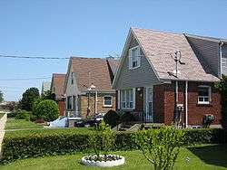 Houses in Dorset Park | |
 | |
| Coordinates: 43°45′55″N 79°16′52″W / 43.76528°N 79.28111°W | |
| Country |
|
| Province |
|
| City |
|
| Community | Scarborough |
| Changed Municipality |
1998 Toronto from |
| Government | |
| • MP | Salma Zahid (Scarborough Centre) |
| • MPP | Brad Duguid (Scarborough Centre) |
| • Councillor | Michael Thompson (Ward 37 Scarborough Centre) |
| Elevation | 40 m (130 ft) |
| Time zone | UTC-5 (EST) |
| • Summer (DST) | UTC-4 (EDT) |
| Area code(s) | (416) and (647) |
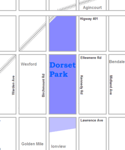
Dorset Park is a neighbourhood in Toronto, Ontario, Canada. It is located in the western part of the district of Scarborough. The neighbourhood is bordered by Highway 401 to the north, Midland Avenue to the east, Lawrence Avenue to the south, and Birchmount Road to the west. Kennedy Road runs along the neighbourhood's centre north and south and Ellesmere Road runs along the centre east and west. The area south of Lawrence Avenue, north of the hydro corridor, is known as McGregor Park and is often included as part of Dorset Park.
Area description
The main high school in the area is Winston Churchill Collegiate Institute, located in the south end of the neighbourhood. The business district of Scarborough is carried right through the heart of Dorset Park along Kennedy Road from Highway 401 to Lawrence Avenue. The business district along Kennedy Road is a 3.5 kilometre stretch of the road with nothing but stores, businesses and high rise buildings. Kennedy Commons, a large strip mall, is located on Kennedy Road, between Highway 401 and Ellesmere Road.
Historical background
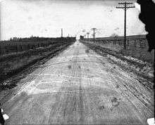
The area was formerly agricultural in nature, with the majority of the housing built in the 1950s.
See also
External links
Places adjacent to Dorset Park | |
|---|---|