North York City Centre
| North York City Centre | |
|---|---|
| Business district | |
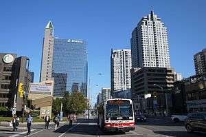 North York City Centre, looking north along Yonge Street | |
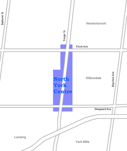 |
North York City Centre is a central business district in Toronto, Ontario, Canada in the district of North York. It is centred along Yonge Street, between Sheppard and Finch Avenues around the Mel Lastman Square civic square. The district is a high-density district of condominium and office towers around the wide six lanes of Yonge Street.
The district was developed following the extension of the Yonge subway north to Finch Station. The former City of North York encouraged the development of the area as a downtown, locating its civic offices, a public square, a central library, an arts centre and an aquatic centre on the west side of Yonge, north of Sheppard. The area's growth increased following the opening of the North York Centre subway station and the Sheppard subway line. A shopping mall and cinemas were developed on the east side of Yonge Street and the sidewalks were built wide and landscaped.
It is located in the official neighbourhood of Willowdale, part of the former city of North York, and a former municipality of its own. Following the amalgamation of North York with the rest of Metropolitan Toronto by the City of Toronto Act amendment in 1997, North York City Centre became the largest of four central business districts in the new city outside Downtown Toronto.[1] All of the civic facilities were retained by the new City of Toronto.
History
In the 1800s, the area was converted to farmland, around settlements made by Jacob Cummer and David Gibson alongside Yonge Street, the former Provincial Highway 11. The postal village of Willowdale was established within York County. North York Township was formed in 1923 from York Township. To the east and west, low-density single-family housing subdivisions were built beginning in the 1920s. As the area's population grew, the roadside became lined with commercial establishments, some being one-level highway arterial-type uses such as gas stations, with others being tightly knit two-storey buildings.
The post-World War II period saw the rapid growth of the suburbs of Toronto. To accommodate the growth, the area was amalgamated into Borough of North York and Metropolitan Toronto in the 1950s. The large expansion of Ontario Highway 401, known as the Toronto Bypass, just to the south connected the district further by highway. The area was filled in by the 1960s with residential single-family subdivisions. By the 1960s, some high rise development was occurring, such as a Canadian Government Building at Yonge and Elmhurst Street and the twin-tower Sheppard Centre commercial and office complex at Yonge and Sheppard. The 1970s saw the extension of the Yonge–University line to Finch, connecting the area to downtown Toronto.
Following the opening of the subway extension, the area along Yonge Street, between Sheppard and Finch Avenues, was chosen by North York and Metropolitan Toronto to be developed into a central business district as the borough progressed to the status of city. An official plan by Metropolitan Toronto encouraged high-density commercial and residential developments in the area. Following the completion of the Scarborough line, North York convinced the Toronto Transit Commission to construct North York Centre, an infill subway station on the Yonge–University line, to connect the new North York Civic Centre complex directly to the subway. It was completed in 1987. In the 1990s, the Sheppard Avenue subway was built along Sheppard Avenue to Don Mills Road to the east, creating a subway crossroads with the Yonge-University line at Sheppard-Yonge Station.
Canada’s deadliest pedestrian attack occurred on April 23, 2018 when a van collided with numerous pedestrians killing 10 and injuring 16 others on Yonge Street between Finch and Sheppard Avenues.[2][3]
Landmarks
The North York Civic Centre office complex and Mel Lastman Square, on the west side of Yonge Street, are central to the area. Across Yonge Street to the east is Empress Walk, a shopping mall that connects directly to the local subway station. North York Central Library, and the Toronto Centre for the Arts are all located adjacent to the square. Further north and south along Yonge Street, office towers, condominium apartment towers and street-level shops line the street.
Gibson House, a museum converted from a mid-19th-century house built by the Canadian politician David Gibson, a Scottish immigrant, land surveyor and participant of the Rebellion of 1837, is also located in this neighbourhood. Earl Haig Secondary School is located on Princess Avenue nearby.
The district is directly served by North York Centre subway station, while Sheppard-Yonge and Finch subway stations are located at the southern and northern edges of the area, respectively. Finch Station is a hub for GO Transit services for commuters from north of Toronto. The area is known for the high-level of traffic on the six lanes of Yonge Street, which connects to the Ontario Highway 401 south of Sheppard.
References
- ↑ "To the True End of Yonge Street VII:
The Downtown that Mel Built". - ↑ Austen, Ian; Stack, Liam (April 23, 2018). "Toronto Van Plows Along Sidewalk, Killing 10 in 'Pure Carnage'". The New York Times. Retrieved April 23, 2018.
- ↑ "All 10 of those killed in Toronto van attack identified". CBC. Retrieved 4 May 2018.