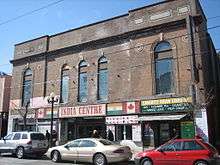
Gerrard India Bazaar
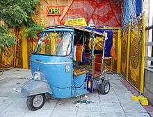
Gerrard India Bazaar is a commercial ethnic enclave in the Leslieville neighbourhood of Toronto, Ontario, Canada. Known as the city's prime "Little India", it consists of Indian, Sri Lankan, and Pakistani restaurants, cafés, grocery stores, and clothing stores catering to Toronto's Desi community. It is entirely situated along a portion of Gerrard Street, between Greenwood Avenue and Coxwell Avenue, forming one of the largest South Asian marketplaces in North America. Although the area has never housed a significant South Asian population, it has historically served as a commercial centre for South Asians living in Greater Toronto and eventually established itself as one of the city's top cultural landmarks. It celebrates the annual Festival of South Asia in late August.[1]
A group of merchants have formed the Gerrard India Bazaar Business Improvement Area (BIA).[2] The BIA sponsors events that appeal to the different South Asian groups that shop in the area: in 2004, Diwali, the Hindu and Sikh festival of lights, and Eid ul-Fitr, the Islamic feast day that marks the end of Ramadan, occurred around the same time in November. The BIA held a joint Diwali-Eid festival.[3]
name="AmeeriarAnthropology2008">Lalaie Ameeriar; Stanford University. Dept. of Anthropology (2008). Downwardly global: multicultural bodies and gendered labor migrations from Karachi to Toronto. Stanford University. p. 1. </ref>
The neighbourhood is serviced by the 506 Carlton streetcar.
History
Toronto's Little Pakistan originated in 1972 when businessman Gian Naaz rented (and later purchased) the Eastwood Theatre on Gerrard Street, which he named the Naaz Theatre, and began to screen Bollywood and Pakistani films, reputedly the first cinema in North America to exclusively screen South Asian films.[4] This attracted large numbers of Indo-Canadian visitors from across the Greater Toronto Area, leading to a number of new businesses opening to cater the South Asian community. The area expanded rapidly and to nearly 100 stores and restaurants spreading over a large stretch of the street between Greenwood Avenue to Coxwell Avenue. Despite there being few South Asians residents in that part of the city, Naz opened his theatre in the economically depressed, largely Anglo-Saxon area because it was the cheapest venue he could find.[4] The success of the theatre resulted in South Asian restaurants and retailers opening in previously empty storefronts as the area became a gathering point for South Asians in the 1970s and the Gerrard Pakistan Bazaar developed and thrived with daily visitors.[5][6]
The growth of Little Pakistan was met with resistance from some in the surrounding, largely Anglo-Saxon neighbourhood with incidents of vandalism and racist violence in the 1970s.[4]
Legacy
While South Asian businesses continue to thrive along Gerrard Street, it lost its central position of South Asian commerce since the late 2000s as an increasing number of South Asian businesses opened in other parts of Greater Toronto to support the growing South Asian immigrant population in the city. Within Toronto, multiple neighbourhoods in Scarborough and Etobicoke contain high concentrations of South Asian businesses. Other South Asian neighbourhoods have also developed in the surrounding cities of Mississauga, Brampton, Vaughan, Markham and Pickering, with rapidly growing communities in Milton and Ajax.
References
- ↑ Brouse
- ↑ Gerrard India Bazaar Business Improvement Area
- ↑ Brouse, Cynthia. "Indian Summer Archived 2011-07-08 at the Wayback Machine.", Toronto Life, September 2005.
- 1 2 3 http://torontoist.com/2012/01/historicist-nights-out-at-the-naaz-theatre/
- ↑ Bauder, Harald. "Toronto's Little India: A Brief Neighbourhood History".
- ↑ Suorineni, Angelica. "Gerrard India Bazaar : an atypical ethnic economy in a residential neighbourhood".
External links
- Toronto's Little India: A Brief Neighbourhood History
- Gerrard India Bazaar Business Improvement Area website
Coordinates: 43°40′18″N 79°19′28″W / 43.67153°N 79.32441°W