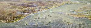
Fort York
 Aerial view of Fort York | |
| Established | 1793 |
|---|---|
| Location | Toronto, Ontario, Canada |
| Coordinates | 43°38′20.50″N 79°24′12″W / 43.6390278°N 79.40333°WCoordinates: 43°38′20.50″N 79°24′12″W / 43.6390278°N 79.40333°W |
| Website | fortyork.ca |
| Official name | Fort York National Historic Site of Canada |
| Designated | 1923 |
| Official name | Fort York Heritage Conservation District |
| Type | Heritage conservation district |
| Designated | 1985 |
Fort York is a historic site of military fortifications and related buildings located in the Fort York neighbourhood, west of downtown Toronto, Ontario, Canada. The fort was built by the British Army and Canadian militia troops in the late 18th and early 19th centuries, to defend the settlement and the new capital of the Upper Canada region from the threat of a military attack, principally from the newly independent United States. It was designated a National Historic Site in 1923.[1] The City of Toronto designated the site, along with the nearby Fort York Armoury, as a Heritage Conservation District in 1985.[2]
History

In 1793, Lieutenant Governor John Graves Simcoe authorized a garrison on the present site of Fort York, just west of the mouth of Garrison Creek on the north western shore of Lake Ontario. Simcoe recognized Toronto was an ideal site for settlement and defence because of its natural harbour and relative longer distance from the United States. Fort York guards the western (at the time of construction, the only) entrance to the bay. Simcoe had decided to make Toronto (which he renamed York) the capital of Upper Canada, and the government, the first parliament buildings and the town were established one and a half miles east of the fort (near the foot of the present Parliament Street).
During the War of 1812, in the Battle of York, on 27 April 1813, U.S. army and naval forces attacked York from Lake Ontario, overrunning the garrison. As the British abandoned the fort, they set the powder magazine to blow up, killing or wounding several hundred U.S. soldiers (including General Zebulon Pike, for whom Pikes Peak is named). The U.S. destroyed what was left of the garrison and burned much of the settlement of York, including the Parliament Buildings during their five-day occupation. They had defeated outnumbered British, Canadian, and First Nations forces, but with the loss of many more men. Following several more U.S. raids over the summer, the British garrison returned to York and rebuilt the fortifications, most of which are still standing today. The rebuilt fort was sufficient to repel a further attempted invasion in 1814.
The British Army had occupied Fort York from 1793 but transferred the site to the Government of Canada in 1869, shortly after Canadian Confederation. The Department of Militia and Defence continued to use the site as a military establishment until 1880, and again during the First and Second World Wars. The site was threatened in 1905 by a proposed streetcar route to the CNE, which would have divided the fort property in two. Following an outcry, the line was not built through the fort. Later in 1909, the Department of Militia and Defence later transferred the property to the City of Toronto with the provision that the city would preserve the Fort's historic structures. On 25 May 1923, the Fort was established as a National Historic Site of Canada. The city undertook restoration work and the Fort was opened to the public in 1934.
In the 1950s, Fort York was again threatened by planned construction of the Gardiner Expressway, but highway planners rerouted the elevated highway to the south of the grounds. On June 28, 1985, Canada Post issued a stamp to Fort York, one of 20 in the "Forts Across Canada Series" (1983 & 1985).[3]
From 1995 to 2008, Fort York hosted Toronto's annual Festival of Beer. Fort York hosted the wheelchair archery events for the 2017 Invictus Games.
The reclaimed lands to the south of the fort have been developed, with new condo towers limiting reconnection with Lake Ontario. However, pedestrian and cycling bridges are under construction (2017) to connect the Garrison Common, at the western end of the National Historic Site, with parks and neighborhoods to the north and south.
Units
British units
The following units of the British Army were posted at Fort York:
- 13th Hussars
- 19th Light Dragoons
- Royal Artillery
- Royal Engineers (Sappers and Miners)
- 1st Regiment of Foot
- 6th Regiment of Foot
- 8th Regiment of Foot
- 15th Regiment of Foot
- 16th Regiment of Foot
- 17th Regiment of Foot
- 23rd Regiment of Foot
- 24th Regiment of Foot
- 26th (Cameronian) Regiment of Foot
- 29th Regiment of Foot
- 30th Regiment of Foot
- 32nd Regiment of Foot
- 37th Regiment of Foot
- 41st Regiment of Foot
- 43rd Regiment of Foot
- 47th Regiment of Foot
- 49th Regiment of Foot
- West Essex Regiment of Foot
- 60th Regiment of Foot
- 66th Regiment of Foot
- 68th Regiment of Foot
- 70th Regiment of Foot
- 71st Regiment of Foot
- 73rd Regiment of Foot
- 76th Regiment of Foot
- 79th Regiment of Foot
- 81st Regiment of Foot
- 82nd Regiment of Foot
- 83rd (County of Dublin) Regiment of Foot
- 85th Regiment of Foot
- 89th Regiment of Foot
- 92nd Regiment of Foot
- 93rd Regiment of Foot
- 97th Regiment of Foot
- 103rd Regiment of Foot
- Rifle Brigade
- Queen's Lancers
Canadian units
.jpg)
The following units of the Canadian militia (both Permanent Active Militia and Non-Permanent Active Militia), and the Canadian Army were stationed at Fort York:
- Royal Newfoundland Regiment
- Glengarry Light Infantry
- Royal Canadian Rifle Regiment
- Queen's Rangers
- Royal Canadian Veteran Battalion
- Royal Canadian Volunteer Regiment
- 3rd Battalion Military Train
- York Militia
- Royal Canadian Dragoons
- HM Canadian Regiment of Fencible Infantry - current unit represented at the fort
- 7th Regiment
- 104th Regiment
- 6th Westmeath
- 26th Regiment
- Royal Fusiliers
- New Brunswick Regiment
- Irish Militia Regiment
- Provincial Marine
- Canadian Voltigeurs
- Royal Canadian Artillery
- Royal Newfoundland Fencibles
- Military Train
- 2nd Battalion of Provisional Militia
- 3rd Battalion of Provisional Militia
- 6th Battalion of Provisional Militia
- 10th Royal Grenadiers
- 48th Highlanders of Canada
- Durham Militia
- Enrolled Pensioners
- Garrison Battery of Artillery
- Home Guards
- Incorporated Militia
- RCA Dragoons
- Toronto Cavalry
- York Militia and Colours
- Toronto Field Battery
Buildings
.jpg)
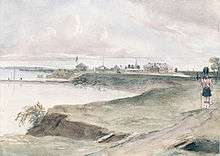
In 1797 a garrison was built east of modern-day Bathurst Street, on the east bank of Garrison Creek. This fort was destroyed in the Battle of York, 1813 (see below). Today's Fort York was largely built by Royal Engineers immediately after the War of 1812. The rebuilt Fort York is located on the original fort site west of Bathurst, at the time on the west bank of Garrison Creek. Fort York's buildings are among the oldest buildings in Toronto today. The original fort buildings were all wood, whereas the current structures are a mix of brick and wood.
A list of current structures at the fort:
- Stone Powder Magazine
- North and South Soldier Barracks
- Blockhouses 1 and 2
- Officer's Quarters
- Blue Barracks
- Brick Powder Magazine
- Lieutenant Governor's Residence c. 1800 and destroyed 1813
Additional buildings located outside the fort were mainly star shaped blockhouses or magazines:
- Spadina Blockhouse 1838/1839-1860s — near College Street and Spadina Avenue (at present day Knox College)
- Sherbourne Blockhouse 1838/1839-1865 - Sherborne Avenue and Bloor Street
- Yonge Blockhouse or Yorkville Blockhouse at Belmont Street (near Budd Sugarman Park) 1838/1839-1860s
- Western Battery - located along the shoreline west of Fort York and later New Fort
- Garrison Creek-Queen Street Blockhouse - near Queen Street west of Bathurst Street
- Ravine Blockhouse - located near military hospital
- Gibraltar Point Blockhouse - originally a battery and near what is now Hanlan's Point Ferry terminal
- Don Blockhouse - Gooderham & Worts and now Distillery District
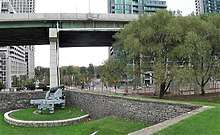
Artillery
_(21146649778).jpg)
Fort York was defended by cannons on the west, north and south:
- 2 ~ 12 pounders — north side
- 1 ~ 14 pounder — west side
- 9 ~ 12 pounders — south side
Bridges
There are two bridges located at Fort York. Garrison Crossing (formerly Fort York Pedestrian and Cycle Bridge)[4] is a two span pedestrian and bicycle bridge being built to connect Fort York with Stanley Park. Completion of the bridge was planned for 2017[5] and is now slated for completion in fall of 2018.[6] It will be built with stainless steel by Dufferin Construction Company.[7] This bridge replaced the Garrison Road Bridge, which carries vehicular traffic under the Gardiner Expressway to Fleet Street. The second bridge is a small footbridge from Bathurst Street which is off limits, and protected by an iron gate.
Fort York Armoury

Southwest of Fort York is the Fort York Armoury, a two-storey structure built in 1933 with private funds. Designed by Toronto architects Marani, Lawson and Morris, it has the largest lattice wood arched roof in Canada.
It is occupied by the Canadian Forces Primary Reserve, the Queen's York Rangers, the Royal Regiment of Canada, and the 32 Signals Regiment (formerly 709 (Toronto) Communication Regiment). It used to be the home of 2 Field Engineer Regiment, the Toronto Scottish Regiment (Queen Elizabeth the Queen Mother's Own), the 48th Highlanders of Canada, and the 1st Battalion Irish Regiment. In addition to being the headquarters of the three active units of the Army Reserve, the armoury is also home to several thriving cadet organizations.
Fort York National Historic Site
.JPG)
The Fort York National Historic Site was established on 25 May 1923, and houses Canada's largest collection of original War of 1812 period buildings. The bulk of its property consists of the area around the old fort. The National Historic Site includes a parcel of land east of Bathurst Street, as well as St. John's Square / Victoria Memorial Square to the northeast. It operates as a museum of the City of Toronto, offering visitors a number of services year round.
The fort's first cemetery at St. John's Square / Victoria Memorial Square is also part of the NHS. The second cemetery for the fort is also located in the Garrison Common section of the site. By the late 19th century twenty eight stones or wooden crosses marked graves, but there were hundreds of mounds.[8] Headstones were later assembled into a memorial wall.
Each April, the site commemorates the US invasion of April 27, 1813, with walking tours, artillery and musket demonstrations, period cooking, and groups portraying units involved in the battle. During the summer months, the site comes alive with the colour and pageantry of the Fort York Guard, and is complimented with tours by professional historical interpreters. In the off-season, the fort is provides educational programs for tour groups including school, scout, guide, and day care groups.
Museum affiliations
The Fort York Museum is affiliated with: the Canadian Museums Association, the Canadian Heritage Information Network, and Virtual Museum of Canada.
See also
References
- ↑ Fort Yprk National Historic Site of Canada. Canadian Register of Historic Places. Retrieved 7 May 2014.
- ↑ Fort York Heritage Conservation District. Canadian Register of Historic Places. Retrieved 7 May 2014.
- ↑ "Canadian Postal Archives Database". data4.collectionscanada.ca.
- ↑ "Major construction on Fort York pedestrian bridge gets underway". CBC News. July 27, 2018. Retrieved 2018-09-05.
- ↑ Fox, Chris (24 November 2015). "City unveils designs for $19.7 million Fort York pedestrian bridge".
- ↑ "Construction begins on pedestrian crossing bridge near Fort York". Global News. Retrieved 2018-09-05.
- ↑ "Made of stainless steel: Fort York bridge first of its kind in Canada". 24 November 2015.
- ↑ Peppiatt, Liam. "Chapter 30: The Military Cemeteries". Robertson's Landmarks of Toronto Revisited.
- Historic Fort York 1793-1993 by Carl Benn, National Heritage and National History Incorporated 1993
External links
| Wikimedia Commons has media related to Fort York. |
- City of Toronto Museums - Fort York National Historic Site
- fortyork.ca - Friends of Fort York
- Historic photos from as far back as the 1890s
| Provinces | |
|---|---|
| Territories | |
| Other countries | |
| |