Cliffside, Toronto
| Cliffside | |
|---|---|
| Neighbourhood | |
 Homes in Cliffside | |
 Vicinity | |
 Location within Toronto | |
| Coordinates: 43°42′40″N 79°14′53″W / 43.71111°N 79.24806°WCoordinates: 43°42′40″N 79°14′53″W / 43.71111°N 79.24806°W | |
| Country |
|
| Province |
|
| City |
|
| Community | Scarborough |
| Established | (Postal village) 'Danforth' |
| Changed Municipality |
1998 Toronto from |
| Government | |
| • MP | Bill Blair (Scarborough Southwest) |
| • MPP | Doly Begum (Scarborough Southwest) |
| • Councillor | Gary Crawford (Ward 36 Scarborough Southwest) |
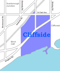
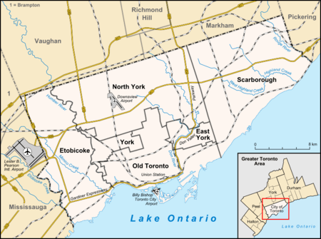
Cliffside is a neighbourhood in Toronto, Ontario, Canada, located along the Scarborough Bluffs in the district of Scarborough. Its boundaries are Kennedy Road to the west (where Kingston and Danforth Road merge), St. Clair Avenue East to the north, Brimley Road to the east, and the Bluffs on the lakeshore to the south. Modern large scale suburban housing subdivision in the area started in the early 1950s post–World War II period with the baby boom and the subdividing of farmland. The area south of Kingston Road was previously a golf course. Some homes were built prior to this period with the development of Birch Cliff to the west.
The population consists of a large number of those with ancestral backgrounds from the British Isles: English 19.8% Scottish 14.4% Irish 11.8%, totalling 46% (source: 2001 Census).[1]
Landmarks
- St. Augustine's Seminary
- Scarborough GO Station
- St. Crispin Anglican Church
- Scarborough Bluffs

References
- ↑ Statistics Canada, 2001 Census, CT's 337 336 343, http://dc1.chass.utoronto.ca/cgi-bin/census/retrieve_census_2001_ct. 3.
External links
Places adjacent to Cliffside, Toronto | ||||||||||
|---|---|---|---|---|---|---|---|---|---|---|
| ||||||||||