Ténenkou Cercle
| Ténenkou | |
|---|---|
| Cercle | |
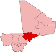
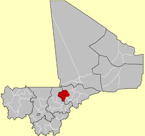 Location of the Cercle of Ténenkou in Mali | |
| Country |
|
| Region | Mopti Region |
| Admin HQ (Chef-lieu) | Ténenkou |
| Area[1] | |
| • Total | 11,297 km2 (4,362 sq mi) |
| Population (2009 census)[2] | |
| • Total | 163,641 |
| • Density | 14/km2 (38/sq mi) |
| Time zone | UTC+0 (GMT) |
Ténenkou Cercle is an administrative subdivision of the Mopti Region of Mali. Its seat is the town of Ténenkou, which is also its largest town. The cercle is divided into communes.
Ténenkou Cercle contains the following ten communes:
References
- ↑ Synthèsis des Plan de Securité Alimentaire des Commune du Cercle de Ténénkou 2006-2010 (PDF) (in French), Commissariat à la Sécurité Alimentaire, République du Mali, USAID-Mali, 2006, archived from the original (PDF) on 2012-09-20 .
- ↑ Resultats Provisoires RGPH 2009 (Région de Mopti) (PDF), République de Mali: Institut National de la Statistique .
| Kayes Region |  | |
|---|---|---|
| Koulikoro Region | ||
| Sikasso Region | ||
| Ségou Region | ||
| Mopti Region | ||
| Tombouctou Region | ||
| Gao Region | ||
| Kidal Region | ||
| Bamako Capital District | ||
| Ménaka Region |
| |
| Taoudénit Region |
| |
This article is issued from
Wikipedia.
The text is licensed under Creative Commons - Attribution - Sharealike.
Additional terms may apply for the media files.