Bankass
| Bankass | |
|---|---|
| Commune and town | |
 | |
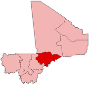
 Bankass Location in Mali | |
| Coordinates: 14°04′N 3°31′W / 14.067°N 3.517°WCoordinates: 14°04′N 3°31′W / 14.067°N 3.517°W | |
| Country |
|
| Region | Mopti Region |
| Cercle | Bankass Cercle |
| Area[1] | |
| • Total | 362 km2 (140 sq mi) |
| Population (2009 census)[2] | |
| • Total | 30,159 |
| • Density | 83/km2 (220/sq mi) |
| Time zone | UTC+0 (GMT) |
Bankass is a town and rural commune located in the Mopti Region of Mali. The commune has an area of approximately 362 square kilometers and includes the town and 25 of the surrounding villages.[3] In the 2009 census it had a population of 30,159.[2] The town is the seat of the Bankass Cercle, one of eight subdivisions (cercles) of the Mopti Region.
References
- ↑ "Common and Fundamental Operational Datasets Registry: Mali", United Nations Office for the Coordination of Humanitarian Affairs https://web.archive.org/web/20121214211137/http://cod.humanitarianresponse.info/country-region/Mali, archived from the original on 2012-12-14 Missing or empty
|title=(help) . commune_mali.zip (Originally from the Direction Nationale des Collectivités Territoriales, République du Mali) - 1 2 Resultats Provisoires RGPH 2009 (Région de Mopti) (PDF) (in French), République de Mali: Institut National de la Statistique, archived from the original (PDF) on 2012-09-19 .
- ↑ Communes de la Région de Mopti (PDF) (in French), Ministère de l’administration territoriale et des collectivités locales, République du Mali, archived from the original (PDF) on 2012-09-19 .
External links
- Plan de Sécurité Alimentaire Commune Rurale de Bankass 2007-2011 (PDF) (in French), Commissariat à la Sécurité Alimentaire, République du Mali, USAID-Mali, 2006 .
This article is issued from
Wikipedia.
The text is licensed under Creative Commons - Attribution - Sharealike.
Additional terms may apply for the media files.