Damada
| Damada | |
|---|---|
| Village | |
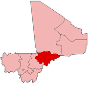
 Damada Location in Mali | |
| Coordinates: 14°44′0″N 3°10′44″W / 14.73333°N 3.17889°WCoordinates: 14°44′0″N 3°10′44″W / 14.73333°N 3.17889°W | |
| Country |
|
| Region | Mopti Region |
| Cercle | Bandiagara Cercle |
| Commune | Metoumou |
| Elevation | 678 m (2,224 ft) |
| Time zone | UTC+0 (GMT) |
Damada is a village and seat of the commune of Metoumou in the Cercle of Bandiagara in the Mopti Region of southern-central Mali.[1]
References
- ↑ Communes de la Région de Mopti (PDF) (in French), Ministère de l’administration territoriale et des collectivités locales, République du Mali, archived from the original (PDF) on 2012-09-19 .
This article is issued from
Wikipedia.
The text is licensed under Creative Commons - Attribution - Sharealike.
Additional terms may apply for the media files.