Bamba, Mopti
| Bamba | |
|---|---|
| Commune | |
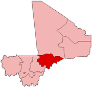
 Bamba Location in Mali | |
| Coordinates: 14°38′38″N 3°5′54″W / 14.64389°N 3.09833°WCoordinates: 14°38′38″N 3°5′54″W / 14.64389°N 3.09833°W | |
| Country |
|
| Region | Mopti Region |
| Cercle | Koro Cercle |
| Population (2009 census)[1] | |
| • Total | 13,610 |
| Time zone | UTC+0 (GMT) |
Bamba is a rural commune of the Cercle of Koro in the Mopti Region of Mali. The commune contains 14 villages[2] and in the 2009 census had a population of 13,610. Most of the population of the commune are Dogon. The administrative centre (chef-lieu) is the village of Déguéré.
References
- ↑ Resultats Provisoires RGPH 2009 (Région de Mopti) (PDF) (in French), République de Mali: Institut National de la Statistique, archived from the original (PDF) on September 19, 2012 .
- ↑ Communes de la Région de Mopti (PDF) (in French), Ministère de l’administration territoriale et des collectivités locales, République du Mali, archived from the original (PDF) on 2012-09-19 .
External links
- Plan de Sécurité Alimentaire Commune Rurale de Déguéré 2007-2011 (PDF) (in French), Commissariat à la Sécurité Alimentaire, République du Mali, USAID-Mali, 2006 .
This article is issued from
Wikipedia.
The text is licensed under Creative Commons - Attribution - Sharealike.
Additional terms may apply for the media files.