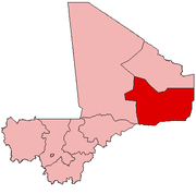
Ansongo Cercle
| Ansongo Cercle | |
|---|---|
| Cercle | |
 Cercle of Ansongo in Mali | |
| Country |
|
| Region | Gao Region |
| Capital | Ansongo |
| Area[1] | |
| • Total | 23,614 km2 (9,117 sq mi) |
| Population (2009)[2] | |
| • Total | 132,205 |
| • Density | 5.6/km2 (15/sq mi) |
| Time zone | UTC+0 (GMT) |
Ansongo Cercle is an administrative subdivision of the Gao Region of Mali. The administrative center (chef-lieu) is the town of Ansongo. The Niger River passes through the cercle and plays an important role in transportation and the economy in the region.
References
- ↑ Synthèsis des Plans de Securité Alimentaire des Communes du Cercle de Ansongo 2005-2009 (PDF) (in French), Commissariat à la Sécurité Alimentaire, République du Mali, USAID-Mali, 2005 .
- ↑ Resultats Provisoires RGPH 2009 (Région de Gao) (PDF) (in French), République de Mali: Institut National de la Statistique, archived from the original (PDF) on 2011-07-22 .
- ↑ Loi N°99-035/ du 10 Aout 1999 Portant Création des Collectivités Territoriales de Cercles et de Régions (PDF) (in French), Ministère de l'Administration Territoriales et des Collectivités Locales, République du Mali, 1999, archived from the original (PDF) on 2012-03-09 .
| Kayes Region |  | |
|---|---|---|
| Koulikoro Region | ||
| Sikasso Region | ||
| Ségou Region | ||
| Mopti Region | ||
| Tombouctou Region | ||
| Gao Region | ||
| Kidal Region | ||
| Bamako Capital District | ||
| Ménaka Region |
| |
| Taoudénit Region |
| |
This article is issued from
Wikipedia.
The text is licensed under Creative Commons - Attribution - Sharealike.
Additional terms may apply for the media files.