Tominian Cercle
| Tominian Cercle | |
|---|---|
| Cercle | |
 Location of the Cercle of Tominian in Mali | |
| Country |
|
| Region | Ségou Region |
| Admin. HQ | Tominian |
| Area[1] | |
| • Total | 6,573 km2 (2,538 sq mi) |
| Population (2009 Census)[2] | |
| • Total | 219,853 |
| • Density | 33/km2 (87/sq mi) |
| Time zone | UTC+0 (GMT) |
Tominian Cercle is an administrative subdivision of the Ségou Region of Mali. The administrative center of the local government is in the town of Tominian. The Cercle is divided into Communes, and below this, quarters/villages. In the 2009 census the cercle had a population of 219,853 people.
References
- ↑ Synthèsis des Plan de Securité Alimentaire des Communes du Cercle de Tominian 2008-2012 (PDF) (in French), Commissariat à la Sécurité Alimentaire, République du Mali, USAID-Mali, 2008, archived from the original (PDF) on 2012-03-18 .
- ↑ Resultats Provisoires RGPH 2009 (Région de Ségou) (PDF) (in French), République de Mali: Institut National de la Statistique .
- ↑ Loi N°99-035/ du 10 Aout 1999 Portant Création des Collectivités Territoriales de Cercles et de Régions (PDF) (in French), Ministère de l'Administration Territoriales et des Collectivités Locales, République du Mali, 1999, archived from the original (PDF) on 2012-03-09 .
- ↑ Communes de la Région de Ségou (PDF) (in French), Ministère de l’administration territoriale et des collectivités locales, République du Mali, archived from the original (PDF) on 2012-09-19 . Names of communes are in upper-case without accents.
| Kayes Region | 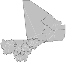 | |
|---|---|---|
| Koulikoro Region | ||
| Sikasso Region | ||
| Ségou Region | ||
| Mopti Region | ||
| Tombouctou Region | ||
| Gao Region | ||
| Kidal Region | ||
| Bamako Capital District | ||
| Ménaka Region |
| |
| Taoudénit Region |
| |

This article is issued from
Wikipedia.
The text is licensed under Creative Commons - Attribution - Sharealike.
Additional terms may apply for the media files.