Dirma
| Dirma | |
|---|---|
| Commune | |
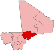
 Dirma Location in Mali | |
| Coordinates: 15°30′53″N 4°12′44″W / 15.51472°N 4.21222°WCoordinates: 15°30′53″N 4°12′44″W / 15.51472°N 4.21222°W | |
| Country |
|
| Region | Mopti Region |
| Cercle | Youwarou Cercle |
| Area | |
| • Total | 699.4 km2 (270.0 sq mi) |
| Population (2009 census)[1] | |
| • Total | 8,121 |
| • Density | 12/km2 (30/sq mi) |
| Time zone | UTC+0 (GMT) |
Dirma is a commune of the Cercle of Youwarou in the Mopti Region of Mali. The main village (chef-lieu) is Ambiri. In 2009 the commune had a population of 8,121.
References
- ↑ Resultats Provisoires RGPH 2009 (Région de Mopti) (PDF) (in French), République de Mali: Institut National de la Statistique, archived from the original (PDF) on 2012-09-19 .
External links
- Plan de Sécurité Alimentaire Commune Rurale de Dirma 2006-2010 (PDF) (in French), Commissariat à la Sécurité Alimentaire, République du Mali, USAID-Mali, 2006 .
This article is issued from
Wikipedia.
The text is licensed under Creative Commons - Attribution - Sharealike.
Additional terms may apply for the media files.