Sofara
| Sofara | |
|---|---|
| Town | |
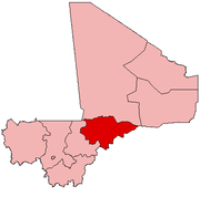
 Sofara Location in Mali | |
| Coordinates: 14°1′3″N 4°13′52″W / 14.01750°N 4.23111°WCoordinates: 14°1′3″N 4°13′52″W / 14.01750°N 4.23111°W | |
| Country |
|
| Region | Mopti Region |
| Cercle | Djenné Cercle |
| Commune | Fakala |
| Elevation | 271 m (889 ft) |
| Time zone | UTC+0 (GMT) |
Sofara (Fula: Kaka) is a small town and seat (chef-lieu) of the rural commune of Fakala in the Cercle of Djenné in the Mopti Region of southern-central Mali.[1] The town lies on the right bank of the Bani River. A weekly market is held in the town on Tuesdays that serves the settlements in the region.[2]
References
- ↑ Communes de la Région de Mopti (PDF) (in French), Ministère de l’administration territoriale et des collectivités locales, République du Mali, archived from the original (PDF) on 2012-09-19 .
- ↑ Quensière, Jacques, ed. (1994), La pêche dans le delta central du Niger: approche pluridisciplinaire d'un système de production halieutique (PDF) (in French), Paris: ORSTOM, Karthala, p. 539 Carte VI, ISBN 2709912023 .
External links
- Schutyser, Sebastian. "Sofara Mosque". Archnet.
This article is issued from
Wikipedia.
The text is licensed under Creative Commons - Attribution - Sharealike.
Additional terms may apply for the media files.