Farimaké
| Farimaké | |
|---|---|
| Commune | |
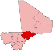
 Farimaké Location in Mali | |
| Coordinates: 15°28′12″N 4°36′44″W / 15.47000°N 4.61222°WCoordinates: 15°28′12″N 4°36′44″W / 15.47000°N 4.61222°W | |
| Country |
|
| Region | Mopti Region |
| Cercle | Youwarou Cercle |
| Area[1] | |
| • Total | 3,148 km2 (1,215 sq mi) |
| Population (2009)[2] | |
| • Total | 11,869 |
| • Density | 3.8/km2 (9.8/sq mi) |
| Time zone | UTC+0 (GMT) |
Farimaké is a commune of the Cercle of Youwarou in the Mopti Region of Mali. The local government is based in the village of Gathi-Loumbo. The commune covers an area of 3,148 km2.[1] It is bounded to the west by the commune of Youwarou, to the north by the communes of Dianké, Léré and Alzounoub, to the east by the commune of Nampalari and to the south by the communes of Kareri, Toguéré Coumbé and Bimbere Tama.[3] The commune lies to the west of the Issa-Ber, the larger of the two branches of the Niger River that flow out of Lake Débo. The commume contains 29 small villages[4] and in 2009 had a population of 11,869. The largest ethnic group are the Fulani (French: Peuls or Peuhls; Fula: Fulɓe) who make up more than 40 percent of the population.[1]
The commune contains around 5,100 ha of land that can be cultivated. The rainfall is low, around 300 mm a year, and with large year-to-year variations. The main crops are pearl millet and sorghum, most of which are consumed by the local farmers themselves. The main economic activity is livestock rearing.[1]
References
- 1 2 3 4 Plan de Securité Alimentaire Commune Rurale de Farimaké 2006–2010 (PDF) (in French), Commissariat à la Sécurité Alimentaire, République du Mali, USAID-Mali, 2006 .
- ↑ Resultats Provisoires RGPH 2009 (Région de Kayes) (PDF) (in French), République de Mali: Institut National de la Statistique, archived from the original (PDF) on 2012-09-19 .
- ↑ Cartographie de la décentralisation au Mali, Direction National des Collectivités Territorial, République du Mali, retrieved 25 January 2011 . Google Earth overlay.
- ↑ Communes de la Région de Mopti (PDF) (in French), Ministère de l’administration territoriale et des collectivités locales, République du Mali, archived from the original (PDF) on 2012-09-19 .