Burang Town
| Taklakot Burang तकलाकोट | |
|---|---|
| Town | |
| Tibetan transcription(s) | |
| • Tibetan | སྤུ་ཧྲེང་རྫོང་ |
| • Wylie transliteration | spu hreng rdzong |
| • IPA | puʂeŋ |
| • official transcription (PRC) | Burang |
| • other transcriptions | Purang |
| Chinese transcription(s) | |
| • Traditional | 普蘭鎮 |
| • Simplified | 普兰镇 |
| • Pinyin | Pǔlán Zhèn |
 Taklakot Burang तकलाकोट Location within Tibet | |
| Coordinates: 30°17′39″N 81°10′34″E / 30.29417°N 81.17611°E | |
| Country |
|
| Region | Tibet |
| Prefecture | Ngari Prefecture |
| County | Burang County |
| Elevation | 4,755 m (13,205 ft) |
| Population | |
| • Total |
|
| • Major Nationalities | Tibetan |
| • Regional dialect | Tibetan language |
| Time zone | +8 |
Burang, known as Purang in Tibetan, is the administrative center of Burang County, Ngari Prefecture of in the Tibet Autonomous Region (TAR) (China). The town lies at 4,755 metres (13,205 feet) altitude in the valley of the Sarayu Karnali River. To the south are Gurla Mandhata (Mount Namonanyi) and the Abi Gamin ranges. Lake Manasarovar and Mount Kailash are to the north. This region is the mythological and actual river nexus of the Himalaya with sources of the Indus, Ganges and Yarlung Tsangpo/Brahmaputra all within 110 kilometres (70 mi) of Burang.
Etymology
The Tibetan name of the town (spu hreng) is a corruption of the Zhang-zhung words pu hrang, meaning 'horse head'. Nepalese and Indians call the town Taklakot (Nepali: तकलाकोट, takalākoț, from Tibetan 'Takla Khar').
Saryu Karnali River's Peacock Mouth[1] source is glaciers on the northern slopes of the Himalaya 50 kilometres (30 mi) NW of Burang. The Lion Mouth source of the Indus is 20 kilometres (12 mi) east of Mount Kailash and the Elephant Mouth is the source of the Sutlej. Lake Manasarovar is just 2km from few of the Sarayu heads, and has an ephemeral connection to Rakshastal. The Horse Mouth source of the Yarlung Tsanpo (Brahmaputra) is about 90 km. (55 mi.) SE of Lake Manasarovar.
History and religion
Burang is an ancient trading post. It is said to be the place where Sudhana, a previous incarnation of the Buddha, lived.[2]
On a cliff above the town was the large ancient fort of Tegla Kar (Lying Tiger Fort) and Simbiling Monastery (both totally destroyed in 1967 by Chinese artillery during the Cultural Revolution, but the monastery has since been partially restored). Beneath them is the Tsegu Gompa or the "Nine-Storey Monastery" which was probably originally a Bön establishment.[3] Tsegu covers many terraces and may be reached by ladders, and contains many unique and ancient wall-painting, darkened from centuries of smoke.[4]
It seems that the Tegla kar (Lying Tiger fort) was built during the Zhangzhung dynasty which was conquered by the Tibetan king Songtsen Gampo in the early 7th century CE. It became the main fort of the Burang Kingdom, in the 10th century under King Kori, one of the two sons of Tashi Gon, King of the Guge Kingdom. The Burang kingdom is believed to have ended in the 15th century.
Burang is the gateway town for travel to Mount Kailash and Lake Manasarovar to the north. These are important destinations for Bon, Buddhist, Hindu, Jain and even New Age pilgrims. Traditional cosmology designates Mount Kailash the center of the universe. Great religious merit is attributed to parikrama around the mountain, and to bathing in Lake Manasarovar.
Transport
Burang is near the borders with India and Nepal. A road leads some 56 kilometres (35 mi) down the Karnali River to the border crossing with China into Hilsa, Nepal (Humla District, Karnali Zone) with a historic trail and now a rough motor road continuing to Simikot. There is also a border crossing into India (Pithoragarh district, Uttarakhand State), over Lipulekh Pass. Beyond the pass the foot trail continues to Dharchula.
National Road S207 begins in Burang, heading NE 65 kilometres (40 mi) past Lakes Rakshastal and Manasarovar to China National Highway 219.
Geography and climate
Burang covers an area of 12,497 square kilometres (4,825 sq mi) and its elevation sits on 4,755 metres (15,600 ft).
Owing to its extreme elevation, Burang’s climate is classified as an alpine climate (Köppen ETH). Winters are frigid but extremely dry, whilst summers are cool and showery due to the influence of monsoonal winds – although the convective influences are lessened at altitudes so high. Minima are below freezing all year round, whilst maxima reach 10 °C or 50 °F only in May before the monsoon makes the summer weather cloudier and colder, with thunder showers and even thundersnow common at this time.
| Climate data for Burang County (1961−present) | |||||||||||||
|---|---|---|---|---|---|---|---|---|---|---|---|---|---|
| Month | Jan | Feb | Mar | Apr | May | Jun | Jul | Aug | Sep | Oct | Nov | Dec | Year |
| Average high °C (°F) | −7.7 (18.1) |
−5.3 (22.5) |
1.3 (34.3) |
7.5 (45.5) |
10.6 (51.1) |
9.3 (48.7) |
4.6 (40.3) |
3.3 (37.9) |
3.7 (38.7) |
3.0 (37.4) |
−1.3 (29.7) |
−6.1 (21) |
1.9 (35.4) |
| Daily mean °C (°F) | −14.4 (6.1) |
−12.1 (10.2) |
−6.4 (20.5) |
−0.5 (31.1) |
3.2 (37.8) |
3.5 (38.3) |
0.7 (33.3) |
−0.1 (31.8) |
−0.6 (30.9) |
−3.5 (25.7) |
−9.0 (15.8) |
−13.1 (8.4) |
−4.4 (24.2) |
| Average low °C (°F) | −21.0 (−5.8) |
−18.9 (−2) |
−14.1 (6.6) |
−8.4 (16.9) |
−4.2 (24.4) |
−2.3 (27.9) |
−3.2 (26.2) |
−3.5 (25.7) |
−4.9 (23.2) |
−10.0 (14) |
−16.6 (2.1) |
−20.1 (−4.2) |
−10.6 (12.9) |
| Average precipitation mm (inches) | 3.2 (0.126) |
3.3 (0.13) |
3.6 (0.142) |
11.2 (0.441) |
28.5 (1.122) |
83.8 (3.299) |
103.1 (4.059) |
91.5 (3.602) |
75.2 (2.961) |
20.4 (0.803) |
3.8 (0.15) |
2.6 (0.102) |
430.2 (16.937) |
| Average precipitation days (≥ 0.1 mm) | 4.0 | 4.1 | 3.9 | 6.8 | 13.2 | 18.8 | 20.1 | 19.3 | 18.8 | 8.1 | 3.0 | 2.8 | 122.9 |
| Source: Weather China | |||||||||||||
References
- ↑ .Snelling, John. (1990). The Sacred Mountain: The Complete Guide to Tibet's Mount Kailas. 1st edition 1983. Revised and enlarged edition, including: Kailas-Manasarovar Travellers' Guide. Forwards by H.H. the Dalai Lama of Tibet and Christmas Humphreys, pp. 74, photo on p. 238. East-West Publications, London and The Hague. ISBN 0-85692-173-4.
- ↑ Tibet Handbook, p. 350. (1999). Edited by Sarah Thorowgood. Passport Books, Chicago. ISBN 0-8442-2190-2.
- ↑ Allen, Charles. (1999) The Search for Shangri-La: A Journey into Tibetan History, p. 55. Little, Brown and Company. Reprint: 2000 Abacus Books, London. ISBN 0-349-11142-1.
- ↑ Tibet Handbook, p. 351. (1999). Edited by Sarah Thorowgood. Passport Books, Chicago. ISBN 0-8442-2190-2.
External links
- Purang: a region joining Tibet, Nepal, and India (Kailashzone Charitable Foundation)
- Photos of Taklakot
| County-level divisions | 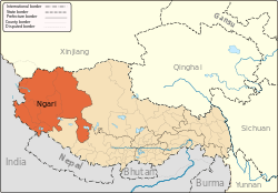 | |
|---|---|---|
| Towns and villages | ||
| Geography | ||
| Landmarks | ||
Coordinates: 30°17′39″N 81°10′34″E / 30.29417°N 81.17611°E