Tegla Kar
| Tegla Kar | |
|---|---|
| Basic information | |
| Location | Burang County, Ngari Prefecture, Tibet, China |
| Geographic coordinates | 30°17′34″N 81°10′34″E / 30.29278°N 81.17611°ECoordinates: 30°17′34″N 81°10′34″E / 30.29278°N 81.17611°E |
The Tegla Kar Dzong was a fort located on a cliff above the town of Burang (also called Taklakot) in Burang County, southwestern Tibet near the Nepalese border. It seems that the Tegla Kar was built during the Zhangzhung period which was conquered by the Tibetan King Songtsen Gampo in the beginning of 7th century. It became the main fort of the kingdom of Burang in the 10th century during the reign of King Kori. The kingdom disappeared during the 15th century. After the decline of the kingdom the Dzong was converted into a convent. Tegla Kar and the nearby Simbiling Monastery was completely destroyed by artillery in 1967 during the Chinese Cultural Revolution.[1]
References
- ↑ Allen, Charles. (1999) The Search for Shangri-La: A Journey into Tibetan History, p. 55. Little, Brown and Company. Reprint: 2000 Abacus Books, London. ISBN 0-349-11142-1.
| County-level divisions | 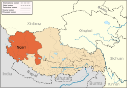 | |
|---|---|---|
| Towns and villages | ||
| Geography | ||
| Landmarks | ||
This article is issued from
Wikipedia.
The text is licensed under Creative Commons - Attribution - Sharealike.
Additional terms may apply for the media files.