China–Nepal border
The border between China and Nepal is 1,236 kilometres (768 mi) in length, along the mountain range the Himalayas, extends northwest-southeast direction, separating the south of Tibet Autonomous Region of China and the territory of Nepal. This border passes through the highest peak in the world, Mount Everest.
The line extends between two tripoints China–Nepal–India. The tripoint in the west is in the Nepalese district of Mahakali Zone. The tripoint in the east is in the region of Mechi.
History
Throughout history, Nepalis traded with the Tibetans via the many border crossings. One of the most important goods traded was salt from the Tibetan areas.[1][2]
The border between Nepal and China is one of the most natural boundaries of the earth, due to the barrier Himalayas.
People's Republic of China and Kingdom of Nepal had a brief border dispute shortly before 1960.[3] They resolved this by officially signing border agreement in 1961.[4]
Border crossings
In 2012, Nepal and China agreed to open new ports of entry, to a total of 6 official ports. Three of the ports are designated as international ports, while three others are only designated for bilateral trade.[5]
The border crossing between Zhangmu and Kodari on the Friendship Highway has been in operation since 1968.[6] In 2014, the border crossing at Rasuwa Fort (Rasuwagadhi) was opened for commerce.[1] However, this crossing is not open to foreigners until 2017.[7][8] In addition, this border crossing is being considered for a future rail crossing between the two countries.[9]
Other crossings like the one at Burang-Hilsa near the western tripoint while not widely accessible has been used for local trade between China and Nepal for many years.[10] Some of those crossings has gotten so important for local trade that in 2008 when Chinese tightened its border control during the Olympics, villages like Kimathanka faced food shortages due to disruption of local trade.[11] Historically, there are even more border crossings. The crossing at Kora La between Upper Mustang and Tibet for example was a major salt trade route. However, this crossing was closed due to Tibetan guerrillas in the 1960s. It remain closed for most of the year to this day, except when opening for limited local trade during the semiannual cross-border trade fairs.[1]
| Treaty Name[5](Other Name) | Jurisdictions[5] | Status | International Transit |
Crossing Location |
Border elevation |
Maximum inside T.A.R. |
Note |
|---|---|---|---|---|---|---|---|
| Burang–Yari (Xieerwa[12]) | Hilsa, Humla District Burang, Burang County |
Active | Planned | 30°09′12″N 81°20′00″E / 30.15333°N 81.33333°E | 3,640 m (11,900 ft) | 4,720 m (15,500 ft) | Local trade currently exists |
| Lizi—Nechung (Kora La) | Lo Manthang, Mustang District Zhongba County |
Planned | No | 29°19′24″N 83°59′09″E / 29.32333°N 83.98583°E | 4,620 m (15,200 ft) | Seasonal trade fair currently exists | |
| Gyirong–Rasuwa | Rasuwa Gadhi, Rasuwa District Gyirong, Gyirong County |
Active | Yes | 28°16′45″N 85°22′43″E / 28.27917°N 85.37861°E | 1,850 m (6,100 ft) | 5,230 m (17,200 ft) | |
| Zhangmu–Kodari | Tatopani, Sindhupalchok District Zhangmu, Nyalam County |
Under Rebuild[13] | Yes | 27°58′24″N 85°57′50″E / 27.97333°N 85.96389°E | 1,760 m (5,800 ft) | 5,150 m (16,900 ft) | |
| Chentang–Kimathanka | Kimathanka, Sankhuwasabha District Chentang, Dinggyê County |
Planned | No | 27°51′30″N 87°25′30″E / 27.85833°N 87.42500°E | 2,248 m (7,400 ft) | Local trade currently exists | |
| Ri'og–Olangchung Gola (Tipta La) | Olangchung Gola, Taplejung District Ri'og, Dinggyê County |
Planned | No | 27°49′00″N 87°44′00″E / 27.81667°N 87.73333°E | 5,095 m (16,700 ft) | Local trade currently exists |
Gallery
 Crossing Bridge near the Rasuwa Fort Gyirong–Rasuwa crossing
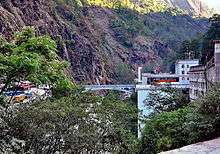 Sino-Nepal Friendship Bridge at the Zhangmu–Kodari crossing
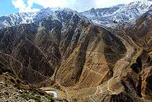 Nara La near the Burang–Hilsa crossing
References
- 1 2 3 Murton, Galen (March 2016). "A Himalayan Border Trilogy: The Political Economies of Transport Infrastructure and Disaster Relief between China and Nepal". Cross-Currents E-Journal. ISSN 2158-9674. Retrieved 2017-02-09.
- ↑ Eede, Joanna (2015-06-12). "Nomads of Dolpo". National Geographic Voices. National Geographic. Retrieved 2017-02-10.
- ↑ Office of the Geographer (1969-05-30). "International Boundary Study - China – Nepal Boundary" (PDF). Bureau of Intelligence and Research. Archived from the original (PDF) on 2012-05-03. Retrieved 2017-02-14.
The exact number of territorial disputes has never been ascertained, but as many as 20 sectors may have been involved. The most serious disputes were located at Rasu (north of Katmandu), Kimathanka in the east, Nara Pass, Tingribode near Mustang, Mount Everest, and the Nelu River. Most of these disputes were settled in favor of Nepal, although several favored China.
- ↑ (in Chinese)

- 1 2 3 "中华人民共和国政府和尼泊尔政府关于边境口岸及其管理制度的协定" [China-Nepal Agreement on Port of Entry] (in Chinese). Chinese Embassy in Nepal. 2012-01-14. Retrieved 2017-02-10.
- ↑ Buddhi Narayan Shrestha (2015-11-29). "Nepal-China Seven Border Crossing-points". Border Nepal Buddhi. Retrieved 2017-02-09.
Kodari-Khasa has been in operation since 1968 for the transaction of trade and commerce. The second commercial border-point is the Rasuwagadhi-Kerung, which has come into use recently.
- ↑ Lobsang (2016-06-25). "Tibet Nepal Border Closed". The Land of Snows. Retrieved 2017-02-09.
the new border crossing from Kyirong, Tibet to Rasuwaghadi, Nepal. Though this border crossing has NOT been opened to foreign travelers yet, this route has been open to traders from Nepal and China for much of the past year...
- ↑ Tenphel, Sonam. "Gyirong Port, new Sino-Nepal Border Finally was Opened, so Lhasa and Kathmandu Overland Tour is all Available Now". Tibet Vista. Retrieved 26 November 2017.
- ↑ "China Wants To Stretch Rail Network All The Way To Touch Bihar: Report". NDTV. 2016-05-24. Retrieved 2017-02-09.
A cross-border railroad link to the Rasuwagadhi area in Nepal has already been discussed between the two countries.
- ↑ Prithvi Man Shrestha; Jaya Bahadur Rokaya (2016-03-24). "Nepal, China rush to open Hilsa border". Kathmandu Post. Retrieved 2017-02-10.
Hilsa is one of the six border points Nepal and China had agreed to open for international trade when former Chinese Prime Minister Wen Jibao visited Kathmandu in 2012.
- ↑ Budhathoki, Kishor (2008-06-04). "China seals border, villages on Nepali side face starvation". The Himalayan Times. Retrieved 2017-02-13.
Starvation looms large in the northern parts of Sankhuwasabha district after China closed the Kimathanka check post
- ↑ "News from China" (PDF). Chinese Embassy in India. Vol. XXVIII no. 7. July 2016. Retrieved 2017-02-15.
- ↑ "Nepal, China working on cross-border rail, dry port". 19 November 2017. Retrieved 6 September 2018.
resumption of Araniko Highway