Suffern station
Suffern | ||||||||||||||||||||||||||||||||||||||||
|---|---|---|---|---|---|---|---|---|---|---|---|---|---|---|---|---|---|---|---|---|---|---|---|---|---|---|---|---|---|---|---|---|---|---|---|---|---|---|---|---|
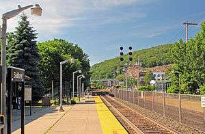 The station at Suffern, looking north along the tracks toward Nordkop Mountain. | ||||||||||||||||||||||||||||||||||||||||
| Location | 2 Ramapo Avenue & Chestnut Street, Suffern, New York | |||||||||||||||||||||||||||||||||||||||
| Coordinates | 41°06′50″N 74°09′14″W / 41.113972°N 74.153894°WCoordinates: 41°06′50″N 74°09′14″W / 41.113972°N 74.153894°W | |||||||||||||||||||||||||||||||||||||||
| Owned by | New Jersey Transit | |||||||||||||||||||||||||||||||||||||||
| Line(s) |
Main Line Port Jervis Line | |||||||||||||||||||||||||||||||||||||||
| Platforms | 2 side platforms | |||||||||||||||||||||||||||||||||||||||
| Tracks | 2 | |||||||||||||||||||||||||||||||||||||||
| Connections |
(2 blocks north on Chestnut Street) | |||||||||||||||||||||||||||||||||||||||
| Other information | ||||||||||||||||||||||||||||||||||||||||
| Station code | 2501 (Erie Railroad)[1] | |||||||||||||||||||||||||||||||||||||||
| Fare zone | 14[2] | |||||||||||||||||||||||||||||||||||||||
| History | ||||||||||||||||||||||||||||||||||||||||
| Opened | 1841[3] | |||||||||||||||||||||||||||||||||||||||
| Rebuilt | March 9, 1887;[4] 1941 | |||||||||||||||||||||||||||||||||||||||
| Traffic | ||||||||||||||||||||||||||||||||||||||||
| Passengers (2012) | 830 (average weekday)[5] | |||||||||||||||||||||||||||||||||||||||
| Services | ||||||||||||||||||||||||||||||||||||||||
| ||||||||||||||||||||||||||||||||||||||||
Suffern is a train station in Suffern, New York, United States, controlled by New Jersey Transit[6] and also used by the Metro-North Railroad. Metro-North's Port Jervis Line joins New Jersey Transit's Main Line at this station. These two lines offer service (usually one-seat) from Port Jervis to Hoboken, New Jersey and New York City via Secaucus Junction. Most trains arriving from Port Jervis and headed to New York/Hoboken during rush-hour do not make any stops between Suffern and Secaucus, though a few also stop at Ramsey Route 17 and Ridgewood on the way. The same is true of trains coming back in the evening rush-hour.
The current station was built in 1941 by the Erie Railroad and replaced an older station near the site of the current New York State Thruway overpass. That older station, built in 1887, was demolished in 1941 when the new station was built. A Wells Fargo Express Mail depot built in 1908 occupies the site and is now a museum.[7]
Suffern is the only station used by New Jersey Transit in New York that does not have Metro North-styled signage trackside, instead employing NJT's black and white signs.
Station layout
This station has two tracks, each with a low-level side platform.
| P Platform level |
Side platform, doors will open on the right | |
| Track 2 | ← Main Line and Bergen County Line alighting passengers only ← Port Jervis Line toward Port Jervis (Sloatsburg) | |
| Track 1 | Port Jervis Line toward Hoboken (Ramsey Route 17) → Main Line and Bergen County Line toward Hoboken (Mahwah) → | |
| Side platform, doors will open on the right | ||
| G | Street level | Station building, ticket machines, parking |
References
- ↑ "List of Station Names and Numbers". Jersey City, New Jersey: Erie Railroad. May 1, 1916. Retrieved November 23, 2010.
- ↑ "Main and Bergen County Line Timetables" (PDF). Newark, New Jersey: New Jersey Transit Rail Operations. November 7, 2010. Retrieved November 27, 2010.
- ↑ Green, M.D., Frank Bertangue (1886). "History of Rockland County". New York, New York: A. S. Barnes & Company. Retrieved June 30, 2017.
- ↑ "Suffern's New Depot". The Evening Gazette. Port Jervis, New York. March 11, 1987. p. 1. Retrieved March 2, 2018.
- ↑ "QUARTERLY RIDERSHIP TRENDS ANALYSIS" (PDF). New Jersey Transit. Archived from the original (PDF) on December 27, 2012. Retrieved January 4, 2013.
- ↑ Saeed, Khurram (April 19, 2007). "NJ Transit approves 10 percent fare hike". The Journal News. p. A.5.
- ↑ "Historical Marker in front of building".
External links
![]()
- Metro-North Railroad - Suffern
- Suffern Railroad Station (Existing Railroad Stations in New York State)
- Chestnut Street entrance from Google Maps Street View
- Station from Google Maps Street View
