Harlem Line
The Metro-North Railroad Harlem Line, originally chartered as the New York and Harlem Railroad, is an 82-mile (132 km) commuter rail line running north from New York City into eastern Dutchess County. The lower 53 miles (86 km) from Grand Central Terminal to Southeast, in Putnam County, is electrified with a third rail and has two (or more) tracks; north of that point, trains use diesel locomotives on a single track. The diesel trains run as a shuttle on the northern end of the line except during rush hours, when they run as expresses to or from Grand Central. There is also one direct roundtrip to Grand Central on weekends.
With 38 stations, the Harlem Line has the most of any Metro-North main line. Its northern terminal, Wassaic, is the northernmost station in the system. It is the only Metro-North line used exclusively by that carrier (no use by Amtrak, though CSX services freight customers as far north as Mount Vernon) and the only one that uses the entirety of existing track. Metro-North has assigned it the color code blue, used as trim on station signs and spot color on printed timetables. The blue color-coding appears to have started with timetables issued by predecessor New York Central as far back as 1965.[1]
While the line has traditionally served to bring commuters from Westchester County to jobs in the city, since the 2000s it has begun to see more "reverse commuting" from the Bronx into Westchester and points north. The northern reaches of the line are also close enough to Western Massachusetts to enable residents of part of that region to commute to jobs in the city as well.[2]:1[3][4]
Line description
The Harlem Line hews closely to roads along river-based transportation corridors dating back to even pre-rail times. It follows three major parkways closely from the Bronx northwards through Westchester: the Bronx River Parkway (and a short portion that becomes the Taconic State Parkway), the Saw Mill River Parkway and Interstate 684. In the last section it also begins to run close to NY 22, the long north-south two-lane state highway that parallels the eastern border of the state. In Westchester, it serves some of that county's most affluent communities as it slowly trends eastward.
Manhattan and the Bronx
The Harlem Line begins at Grand Central Terminal. The train tracks rise to ground level north of 97th Street in Manhattan. After stopping at Harlem–125th Street, the Harlem Line crosses the Harlem River at 135th Street in Manhattan, entering the Bronx.
In the Bronx, the Harlem Line cuts through the neighborhoods of the southwest Bronx, with two stations: Melrose, at 162nd Street (it then runs under the Cross Bronx Expressway (I-95) and Tremont, at 177th Street. Fordham station is next, at Fordham Road (190th Street). The Harlem Line then parallels the western edge of Fordham University until the Botanical Garden station at Bedford Park Boulevard (200th Street).
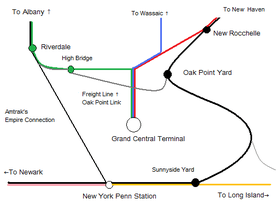
The Harlem Line then cuts northeast to join the Bronx River Parkway, which lies to the east of the tracks. The Williams Bridge station is next, at Gun Hill Road (210th Street). After the Williams Bridge station, Woodlawn Cemetery begins to the west of the tracks, with Webster Avenue in between the cemetery and tracks. The Woodlawn station is at 233rd Street, and it is north of here that the New Haven Line diverges to head east towards the Northeast Corridor.
The Harlem Line then goes under a bridge for the parkway, and it remains to the west of the tracks until Scarsdale station. The Wakefield station at 241st Street concludes the Bronx portion of the Harlem Line.
Westchester County
The Westchester portion of the Harlem Line begins at Bronx River Road in southeastern Yonkers. After the Mount Vernon West station, the Harlem Line runs along the on-ramp to the Cross County Parkway eastbound, right before Fleetwood station. After the Bronxville station, the Harlem Line parallels the Bronx River Parkway all the way up to White Plains.
From White Plains, the railroad winds its way through the city and passing through the yards at North White Plains, which was the northern boundary of third-rail electrification until 1984. The stretch north of North White Plains is unique because it is the only third-rail electrified stretch of Metro-North's network that has grade crossings, a byproduct of its existence pre-electrification. Katonah and Brewster stations are located right next to grade crossings.
After North White Plains, the next station is Valhalla adjacent to the Taconic State Parkway. The double-track railroad then curves to follow the Saw Mill River Valley and the eponymous parkway. Rail and road briefly separate at Mount Kisco, but then remain close by at the last stop along the Saw Mill, Bedford Hills (although the parkway cannot be seen from the station).
Past Katonah, the railroad runs between the Croton River and I-684. Golden's Bridge and Purdy's are both located very close to the interstate, although only the former can be seen from it. North of the latter, the tracks follow the river to Croton Falls, and pick up Route 22 for the first time.
Putnam County
After Croton Falls station, the Harlem Line runs along East Branch Reservoir and crosses into Putnam County and its rural landscape. Above Brewster station, the railroad passes through the yards at Putnam Junction to Southeast station, which was formerly known as Brewster North. This is the northern boundary of third rail electrification. North of here, the line operates with a single track and uses diesel locomotives. This section is also known as the Wassaic Branch. The branch is not signalized, and manual block system rules are used to direct train movements.[2]:I-2 The track finally follows its own course, away from any road or river, past the former Dykemans and abandoned Towners stations up to Patterson and into Dutchess County.
Dutchess County
Shortly before reaching Pawling, the line enters the Harlem Valley (which takes its name from the railroad) and begins to parallel Route 22, although not as closely as it did the roads further south. A few miles north of Pawling, the Appalachian Trail crossing has its own stop to allow thru-hikers to take a break in the city and day hikers to visit the nearby Pawling Nature Preserve.
The next two stops, Harlem Valley–Wingdale and Dover Plains, are roughly eight miles (13 km) apart, the longest distance between any two stops on the Harlem Line. From 1972 to 2000, Dover Plains was the last stop on the line, but then tracks remaining from the NYCRR era that had not yet been torn up were renovated and the line was extended to Tenmile River and its new northern terminus, Wassaic. A small yard where diesel trains await their routes just past the station marks the end of the line.
History
Origin as a streetcar line
The Harlem Line in its current form originated from the New York and Harlem Railroad (NY&H), which was the first streetcar company in the United States and in the world. It was franchised, on April 25, 1831, to run between the original city core in lower Manhattan to the suburb of Harlem, several miles to the north on Manhattan Island. The railroad's charter allowed the line to run between 23rd Street and any point on the Harlem River between Eighth and Third Avenue, with a branch running to the Hudson River, encompassing most of the island.[5]:5–7[6]:2
While the company wanted to run the line as a steam line, the city made it use horsepower south of 14th Street.[7][8]:3 On September 13, 1831, the Board of Directors of the railroad approved its route along Fourth Avenue (renamed Park Avenue on March 1, 1888) from 23rd Street to the Harlem River. On April 6, 1832, the railroad's charter was amended to allow the line to be extended south to 14th Street.[5]:8–10
On May 2, 1832 the City Common Council secretly granted the railroad the right to lay track along Broadway to City Hall and Bowling Green. There was a public outcry once this was found out by the general public, and at the time a fraudulent map was circulated showing that the railroad would take up 23 feet (7.0 m) of the street when it would only take up 5 feet (1.5 m). Newspaper editors also came out against the railroad's plan. In Spring 1833, the railroad published a pamphlet to refute objections to their plan titled "A Statement of Facts in Relation to the Origin, Progress, and Prospects of the New-York and Harlem Railroad Company." On March 1, 1833, a meeting was held in Tammany Hall concerning the issue, and at the meeting cab drivers and owners came out against the railroad. After the meeting, the crowd tore up some of the railroad's track. After the meeting, the council withdrew its Broadway agreement with the railroad. The railroad was extended downtown in 1839, but along a different route.[6]:6
Ground was broken on the construction of the line on February 23, 1832 at Murray Hill on Fourth Avenue. At the ceremony, Vice President of the railroad, John Mason hinted at the railroad's ambitions saying that while the railroad's principal objective was local, its higher importance was to get to Albany.[6]:3 In 1832 the company was given permission to raise its stock limit to $500,000. In November, two horsecars built by John Stephenson were ready for operation, both of which were named after the railroad's president ("John Mason" and "President").[6]:4
On April 27, 1837, an act was passed in the State Legislature to widen Fourth Avenue between 32nd Street and the Harlem River to provide room for the railroad. The street was widened by 20 feet (6.1 m) on either side, making the street 140 feet (43 m) wide. The company ceded the title for the land that would be occupied by Fourth Avenue to the city in exchange for permission to occupy it.[6]:6 In that same year, the railroad purchased six city lots at Fourth Avenue and 26th Street for $7,000 for the construction of car barns and stables.[6]:7
The first section, along Bowery from Prince Street north to 14th Street, consisting of .85 miles (1.37 km), opened to the public on November 26, 1832.[5]:8 On that day a demonstration showing the car's braking ability was conducted, but inadvertently, one horsecar rear-ended into another with no serious injuries. This might have been the first rear-end collision in the United States.[6]:5 Service was then extended northward along Fourth Avenue to 32nd Street on June 10, 1833. The Murray Hill rock cut was completed in 1834, and service along a 4.432 miles (7.133 km)-long segment to 85th Street in Yorkville opened on May 1, 1834. Service ran every 15 minutes between 5 a.m. and 8 p.m., and ran every 60 minutes to 10 p.m.. A one-way fare cost 12.5 cents[6]:7 Service was extended 2 miles (3.2 km) to finally reach Harlem on October 26, 1837, with the Yorkville Tunnel constructed to reach this point.[7] At the time, Harlem was just a small suburb of the city.[5]:13 Service was also extended further south. On May 4, 1839, the line was extended south along Bowery, Broome Street and Centre Street to City Hall at Centre Street and Park Row. Service was extended south on November 26, 1852 along Park Row to Astor House at Park Row and Broadway.[9]
Extension toward Albany
The New York and Albany Railroad had been granted its charter on April 17, 1832, allowing it to build a single or double-track line from Greenbush (on the opposite side of the Hudson River from Albany) to New York along the Harlem River. In 1836 amendment to its charter granted it the right to enter Manhattan along a route that they "may deem most eligible"–direct competition to the NY&H. The NY&A had periods of inactivity, in part due to the financial panic of 1837. Surveys were completed in some places, and ground was proken in various areas. Gouverneur Morris, a Vice President and Director of the NY&A, reached an agreement with the Harlem. The NY&H would pay the NY&A's expenses on surveying with the understanding that the NY&H would be extended to Greenbush. The deal was completed on February 28, 1840, and on May 7, 1840, the New York State Legislature granted the Harlem the right to extend into Westchester. The corporate life of the NY&A ended on March 9, 1846 when it was bought by the Harlem.[6]:8
The line was not being completed as quickly as its charter required, so the New York State Legislature granted it multiple extensions to allow for the work to be completed. The last time an extension was granted was on April 11, 1842. The New York and Harlem Railroad bought that company for $35,000 on March 9, 1846, as it had failed to make any progress on the construction of the line. The right-of-way and land for that line was sold as part of this transaction, on which, it built its line into Westchester, Putnam, Dutchess, and Columbia Counties.[5]:9–10
Service was extended into Westchester in multiple stages. The line was first extended north 4 miles (6.4 km) into Westchester on December 14, 1840, before reaching Fordham on March 1, 1841. Extended service reached Williams Bridge on September 3, 1842, and then in the summer of 1844, the line reached Tuckahoe. On December 1, 1844, the line's terminus became White Plains, but in October 1846, trains began ending their runs at Pleasantville.[5]:14 Service reached Mount Kisco and Croton Falls, in February 1847, and on June 1, 1847, respectively. On December 31, 1848, Harlem Railroad service was extended to Dover Plains, providing service to parts of Putnam County and Dutchess County.[2]:D-3
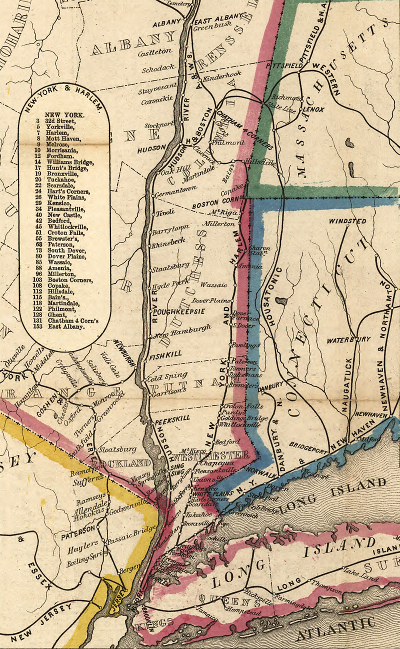
On May 10, 1852, the line was extended north to Chatham Four Corners in Dutchess County with a connection to the Boston and Albany Railroad, and trackage rights northwest to Albany. In the years following, the Harlem Railroad ran some of its trains over the Boston and Albany Railroad from Chatham to Albany.[5]:15, 17 Additional connections could be made to railroads serving North Bennington, Vermont and other points in western Vermont. Chatham is about 52 miles (84 km) past the current terminal at Wassaic. In Boston Corners, about 12 miles (19 km) north of Wassaic, passengers could make connections to the Central New England Railroad (CNE). To the east, the CNE went to Hartford, Connecticut. Westward, passengers could travel to Poughkeepsie, cross the Poughkeepsie Bridge, finally to Campbell Hall.[10][11]
A 1.84 miles (2.96 km)-long freight branch, from the 1853 purchase of the Spuyten Duyvil and Port Morris Railroad, was built to Port Morris.[12][13]
In 1871, the depot that the line used was changed from being at 26th Street and Fourth Avenue to Grand Central Depot at 42nd Street.[5]:27
Under the New York Central
On April 1, 1873, the New York and Harlem Railroad was leased for 401 years to the New York Central and Hudson River Railroad Company. The line then became the Harlem Division of the New York Central. The lease did not include the portion of the line using horse cars. Horse cars were replaced with an underground trolley system in 1897 when it was leased to the Metropolitan Street Railway Company.[5]:25–26
In 1875, the line was grade-separated and put in an open cut and a viaduct between Grand Central and the Harlem River to reduce the loss of life and to increase speeds. The work was completed for $6,000,000, of which half was paid by the city.[14]
On May 15, 1876, partial rapid transit began on the Harlem Line, with sixteen trains a day running between Grand Central Depot and William's Bridge. These trains made all stops between Grand Central and William's Bridge, with the exception of Jerome Park, which was skipped by half of trains. This was in addition to eight regular trains per day that stopped at William's Bridge. Two new stations were opened at 86th Street and 110th Street, both being exclusively served by the rapid transit service.[15][16]
On February 15, 1897, trains on the Harlem Division started running over the new drawbridge over the Harlem River and the elevated structure connecting to it.[5]:25 As part of the project, the line north of 106th Street to the Harlem River was elevated so that it could reach the height of the new four-track drawbridge, the only one in the country at the time. The project was known as the Park Avenue Improvement. The new line went via a steel viaduct, replacing a masonry viaduct and an open cut. The 400 feet (120 m) bridge was built for about $500,000 by the King Bridge Company. The new bridge is 24 feet (7.3 m) higher than the old bridge, as mandated by the Federal Government. During the course of construction, trains ran over a temporary wooden structure along with a temporary wooden drawbridge. The station at Mott Haven on the Bronx side of the Harlem River had to be elevated. The entire cost was $2,000,000.[14][17]
On October 15, 1897, a spacious new station in Harlem was opened at 125th Street, replacing a small, dingy station in the old Park Avenue open cut. The new station was built atop the old open cut and directly under the new Park Avenue Viaduct. The platforms, which were built on the viaduct, were built to be 400 feet (120 m) long.[18]
In November 1907, the first electric train operated on the Harlem Division, running between Grand Central Terminal and Wakefield.[19] On October 10, 1909, the New York Central began installing third rail between Mount Vernon and White Plains.[20] On March 14, 1910, electric service was extended to North White Plains. Passengers that used the Upper Harlem Division were attracted to this cleaner, faster service.[21]:225 Property values along the line increased. Other improvements were made to the Harlem Division at the same time: grade crossings were being eliminated, tracks were being straightened, and new stations were built at White Plains and Mount Vernon.[22]
In 1910, a yard dating back to the 1870s in Dover Plains was relocated to Putnam Junction in Brewster.[2]:17-1
On October 18, 1930, the Public Service Commission (PSC) listed the elimination of a grade crossing in Amenia, Benson crossing, as one of its projects to consider. The cost estimate for eliminating it was $100,000.[23]
On September 12, 1952, the New York Central's last steam-powered train run in the metropolitan area ran on the Harlem Division, being replaced by diesel locomotives.[24] However, they began wearing out in the 1970s, leading to a decline in service.[25]:47
On December 20, 1956, the state opened up bids for the elimination of grade-crossings in Pleasantville. Planned for 25 years, it was expected to cost $3,857,000. The crossings to be eliminated were at Manville and Bedford Roads. The tracks were lowered for 7,000 feet (2,100 m) and the two roads were bridged over the railroad. The station at Pleasantville was moved.[26]
On August 12, 1960, the PSC ordered the New York Central to continue the level of service to Chatham until it determined how much service was required. The Central had wanted to cut one train each way daily, leaving only one round trip.[27]
Starting on October 25, 1961, some trains became equipped with two-way radio communication on the Harlem Line to test the technology with the hope of adding them to all commuter trains on the New York Central. They were meant to be used when delays in service occurred.[28]
On January 10, 1964, the PSC approved plans by the New York Central to implement zoned fares in the southern part of the New York commutation area (north to North White Plains). The plan went into effect on January 22. Though it was meant to be experimental, and to last one year, this was kept in place.[29]
Decline under Penn Central
In May 1970, the Penn Central planned to discontinue service from Dover Plains to Chatham when Amtrak declined to take over that service. However, the Attorney General maintained that this service was within the commuter area, and therefore not subject to discontinuation. Without the objection, this service would have been eliminated on May 1, 1971 when the Amtrak passenger service went into effect. The Interstate Commerce Commission (ICC) held hearings on this in May 1971, and it ruled on June 28, 1971 that the service to Chatham was intercity–not commuter. On that same day, a bill that would have extended the power of the Metropolitan Transportation Authority to Chatham was vetoed by Governor Nelson Rockefeller. On July 31, 1971, Penn Central announced that it would discontinue all service to Chatham the following day. The railroad claimed that it lost $300,000 a year on the one round trip between Chatham and Grand Central.[30][31]
The Attorney General appealed the ICC's ruling, and this appeal was tried in March 1972, but failed, resulting in the discontinuation of service from Dover Plains to Chatham on March 20, 1972. Penn Central operated the last southbound passenger train between Chatham and Grand Central Terminal on March 20, 1972, ending service in the middle of the day. Train 935, which was scheduled to leave Grand Central at 4:25 PM and run to Chatham was cut back to Dover Plains. With no scheduled return trip to Chatham, passengers who had gone south in the morning were left stranded, with service going only as far north as Dover Plains (52 miles shy of Chatham).[32][31] Tracks were removed north of Millerton shortly thereafter. The cutback of service to Chatham was strongly opposed by the Harlem Valley Transportation Association (HVTA), which was led by Lettie Gay Carson.[2]:26–67
Prior to the discontinuation of service to Chatham, the quality of service on the line decreased. Trains that could once run the 127 miles (204 km) to Chatham in 2 hours 45 minutes now took 3 hours and 45 minutes. Service had been decreased from five trains a day to one train in each direction. As service was discontinued, a bill was put before the State Legislature that would have authorized the state to run trains to Chatham between New York and Montreal and from Albany toward Boston. The bill did not pass.[31]
Several other stations had their service discontinued in 1972, including: 138th Street, Morrisania, and 183rd Street stations in the South Bronx, and Holland Avenue station in White Plains, although that one was replaced.
The Metropolitan Transportation Authority (MTA) leased the line south of Dover Plains from Penn Central on June 1, 1972. On March 28, 1980, the last freight train ran between Dover Plains and Millerton, and the line was abandoned three days later after the line's largest shipper decided to switch to using trucks.[33][34]:211 All freight service ended in 1993.[2]:17-2 and 18-1 Tracks were removed from Wassaic to Millerton. In 1989, New York State purchased 21 miles (34 km) of the right-of-way between Wassaic and Copake Falls for the development of the Harlem Valley Rail Trail. The segment of the line that ran from Wassaic to Craryville, New York is now under control of the Harlem Valley Rail Trail Association, which currently has trails operating from Wassaic to the former Millerton station and between Under Mountain Road and Copake Falls, known as the Harlem Valley Rail Trail.[2]:10–1
Growth under Metro-North
High-level platforms
In April 1971, a project to install high-level platforms at stations along the Harlem Line started. This was necessary as the new Metropolitan cars did not have any stairs to reach the low-level platforms. By having high-level platforms, dwell times could be cut in half. Most of the new platforms were built as island platforms. These cars started entering into service in September 1971.[35]:31 At the same, time reverse signaling was installed to allow trains to use either track in either direction, enabling both tracks to be used in one direction during the peak of the rush hour.[36] On September 10, 1974, the MTA announced that work would start on the construction of high-level platforms at eleven stations in Manhattan and the Bronx including at the Wakefield, Woodlawn, Williamsbridge, Botanical Garden, Fordham and Tremont stations on the Harlem Line. The entire project cost $2.8 million. The work was expected to be completed in the late summer of 1975. As part of the work the stations on the Harlem Line received 340 feet (100 m)-long cast-in-place concrete platforms. The abandoned station building at Woodlawn was removed as part of the project.[37] On March 15, 1975, these cars started stopping at the Melrose, Tremont, Fordham, Botanical Garden, Williamsbridge, Woodlawn and Wakefield stations on the Harlem Line with the partial completion of their high-level platforms. However, initially they only served the stations during weekends and early mornings and evenings on weekdays until the platform work was completed.[38]
Electrification
The extension of electric service to Brewster had been discussed since the late 1920s. Numerous improvement studies were undertaken to evaluate the feasibility and benefits of extending electrification north from North White Plains. In 1976, the MTA undertook a study on the existing traction power system and it identified extending electric service to Brewster as a priority.[21]:225 In December 1978, the MTA applied to the Urban Mass Transportation Administration (UMTA) for $30 million in funding to extend electrification along the Harlem Line from North White Plains to Brewster North (now known as Southeast). The MTA's application for funding was granted, with the remainder of the money coming from a New York State bond issue from 1974.[39]
On February 8, 1980, Metro-North announced its plan to extend electrification to Brewster.[33] On November 25, 1980, the MTA's chairman, Richard Ravitch, announced that $3 billion should be spent to expand and improve transit service. As part of the plan he proposed extending electrification to Brewster, for which planning was underway, and proposed building a third track along the Harlem Line between North White Plains and Mount Vernon West for $30 million.[40] On February 5, 1981, the UMTA approved the contract for the third rail required for the project.[39] For an additional $45 million, high-level platforms were installed to reduce dwell times, and electric substations were built to supply the power needed for third-rail operation. The project was approved by Governor Hugh Carey after Upper Harlem Line riders and commuter organizations–dissatisfied by the line's service–petitioned for the project. Initially, the work was to be completed by the end of 1983, but due to a strike, its completion was delayed to 1984. Initially, service was provided with a mixture of new and old electric cars, but these were replaced by the new M3s. Work on the project was completed during off-peak hours to allow for service on the line to be maintained. Thirteen of the stations received new high-level center island platforms. Mount Pleasant station got side platforms, while the station at Thornwood was closed because of excessive curvature of the track, which would have resulted in a large gap between the train and the platform. The new stations received glass-enclosed overpasses and elevators.[41]
The first electric train ran on April 30, 1984, beginning at Brewster North. As additional new M3s were put into service that spring, electric service increased. On September 1, 1984, a new schedule was put out, and running times decreased by 18 minutes on peak hour trains.[21]:238 On September 10, 1984, super express service was inaugurated on the Harlem Line, with some trains running non-stop between Katonah and Grand Central. The last diesel train left Brewster on November 2, 1984, marking the completion of the electrification project.[33]
As a result of the project, there was tremendous ridership growth on this portion of the line.[41] Prior to the project, the line was operated primarily in two zones: electric service south of North White Plains, and diesel through-service or shuttle service consisting of Budd Rail Diesel Cars to the north. Service to the north of Brewster North–the new terminal for electric service–continued to be run with diesel through-service or shuttle service.[34]:527 Between 1984 and 1994, the Brewster and Brewster North stations– the two northernmost stations in the electrified zone–experienced 135% growth, and stations on the Dover Plains Branch experienced 440% growth.[2]:1–9
Upper Harlem improvements
The introduction of new coaches allowed for improvements in service on the Dover Plains Branch. The first peak through service since the 1970s was inaugurated in October 1991. At the same time, a Sunday night through train was added. The reduced travel times made the line more attractive to commuters. In 1994, Metro-North conducted a train movement analysis of service on the branch to determine whether trains would pass one another based on speeds and the condition of tracks. As a result, a new 1,000 feet (0.30 km) passing siding was constructed at Wingdale, increasing service flexibility and allowing for increased service in 1996. Also around this time, 447 additional parking spaces were added to stations on the Branch. In 1996, four car length high-level platforms with heated shelters were built at Patterson, Pawling, Harlem Valley–Wingdale and Dover Plains, replacing low-level platforms that could only accommodate two cars. These platforms were made to be compliant with the Americans with Disabilities Act of 1990. Travel times could be reduced further as it would take less time for passengers to exit and board the trains.[2]:1-6 to 1-7, 26-12 and 26-28
A new station, Appalachian Trail, was built in 1991 for the cost of $10,000. Its creation was the suggestion of George Zoebelein, who was an avid hiker and a veteran of the NY/NJ Trail Conference as well as both the NY/NJ Appalachian Trail Conferences, and also served as a member of the Metro-North Railroad Commuter Council (MNRCC) of the Permanent Citizens Advisory Committee (PCAC) to the Metropolitan Transportation Authority. It is one of three limited service stops operated by Metro-North primarily for hikers – the other two being Breakneck Ridge and Manitou on the Hudson Line.[42] This is the only rail station on the 2,144 miles (3,450 km)-long trail.[43]
On December 9, 1992, the ICC authorized Conrail to convey its freight rights on the Harlem Line north of North White Plains to the Danbury Terminal Railway Company (DTRC). In 1995, the ICC directed the DTRC to discontinue freight operations on the line, as it had not been used for freight service in several years.[2]:13–6
Restoration of service to Wassaic
In 1993, Metro-North announced plans to restore service north of Dover Plains to Wassaic. Initially, the project was estimated to cost $12.8 million. The extension was intended to help revive the community of Wassaic, and to turn it into a hub where passengers would come from Litchfield County in Connecticut, the Berkshires in Massachesetts, and from Vermont.[44]
On October 19, 1995, the town of Amenia passed a resolution supporting the Harlem Line's extension by 6 miles (9.7 km) to Wassaic.[45]
On January 23, 1997, Metro-North acquired the property necessary for the extension of service on the Upper Harlem Division to Wassaic. In August 1997, the Final Environmental Impact Study for the Wassaic extension was completed, recommending that preferred option, the extension of service to Wassaic be completed.[2]:1–17 One of the rejected alternatives, was the restoration of service to Millerton and Mount Riga in Dutchess County. A layover yard would have also been built as part of this alternative. This alternative was rejected due to the presence of the Harlem Valley Rail Trail, and replacing it with rail service would have required an in-kind replacement of any taking of parkland. Since a majority of the line was not owned by Metro-North it was viewed as being cost-prohibitive.[2]:2-4, 2-9 and 2-13 In July 1998, Metro-North announced the names for the new stations on the extension: Tenmile River and Wassaic.[46]
In April 1999, the MTA put out bids to purchase signal equipment to go along 28 miles (45 km) of the line from Brewster to Wassaic. The signal system was bi-directional with cab signaling.[47]
On July 9, 2000,[48] Metro-North restored service between Dover Plains and Wassaic, a move the railroad billed as its first service expansion since it was created in 1983.[3][49] As part of the project, the trailhead of the Harlem Valley Rail Trail was moved from milepoint 81.6 to milepoint 82. 6,152 feet (1,875 m) of right-of-way had to be acquired from the New York State Office of Parks, Recreation, and Historical Preservation. To make up for this loss, $490,800 was received by the Transportation Enhancement Program to design and construct an access pathway from Wassaic station to the new trailhead.[2]:23-3 and Appendix H-1 Wassaic was designed as and is a regional transportation hub for people living and going to Dutchess County in New York, Litchfield County in Connecticut and for Western Massachusetts. The station was built with a 250-space parking lot that, with expansion, could have 1000 parking spaces, and with a layover yard, and a light maintenance facility. One of the goals of the expansion was to provide additional parking capacity for the line. Prior to the opening of the yard at Wassaic, trains terminating at Dover Plains had to deadhead 23 miles to get to the yard at Southeast, reducing capacity on the line, while being very costly. A station was also opened at Tenmile River to serve the Taconic Developmental Disabilities Service Office. Under an alternative plan, this would have been the terminus of the line.[2]:1-14 and S-1 to S-3 In order to build ridership, the extension has received the same amount of service as has the line south of Dover Plains, with four AM and four PM rush hour trains with direct service to Grand Central.[50][51] In fact, since 1984, weekday ridership on trains to Dover Plains increased by 463 percent to a total of 535 peole riding south daily. The extension cost $6 million.[3] The extension also eased the commutes of people coming from Massachusetts.[4]
Mid-Harlem third track project
Early in 1994, Metro-North announced plans to build a third track along 2.5 miles (4.0 km) of the Harlem Line between Mount Vernon West and Crestwood to increase capacity and to eliminate a bottleneck.[52] At the time, Harlem Line ridership was growing, with an expected 31 million people using the line in 2020. Without the construction of an additional track, only one southbound peak-hour train could have been added without cutting local service, express service, or reverse peak service.[53] In August 2001, construction on the $57 million project began.[54] The project was completed in 2004. The Fleetwood and Crestwood stations were expanded through the adding of island platforms to allow for the third track to stop there. The right-of-way was wide enough to fit the third track, requiring no taking of property. The plan for the installation of a third track was first conceived in 1989, but it was faced with strong community opposition due to concerns over noise, vibrations, and as they had illegally built structures on Metro-North property which they did not want removed. Once opened, the third track resulted in improved service. Reverse-peak trains were able to run every 30 minutes instead of every 90 minutes, helping fuel a 30 percent increase in ridership along the line through Southern Westchester and the Bronx. Most of the new reverse-peak users came from the Bronx. The increased service helped revitalize White Plains' downtown, helping anchor the economy of central Westchester.[55] Express trains could skip stops via the express track while additional local trains could make stops in Westchester and the Bronx.[56]
On February 3, 2015, a Harlem line train struck a car on the tracks near Valhalla and caught fire. Seven people were killed and service was temporarily suspended between Pleasantville and North White Plains.[57][58]
Future
With the entire existing track in use since service to Wassaic was restored in 2000, there is little talk of expansion or branching. However, Metro-North will revisit a future extension northward if circumstances change.[2]:26-12 When plans were drawn up for extending the line northward from Dover Plains, the goal for Metro-North was to extend the line as far north as possible for a new yard, and to attract the most new passengers. Wassaic was the best site, and service was not extended to Millerton as the Harlem Valley Rail Trail was using the right-of-way.[59] This directly contrasts one of the main purposes of rail trails: to preserve the right-of-way to allow for rail service to be restored in the future.[60] For now, Metro-North and the MTA have focused on improving existing facilities on the line, particularly stations such as Brewster where increasing usage has caused parking shortages.
In the 2015–2034 MTA Twenty-Year Capital Needs Assessment, two possible Harlem Line projects that would provide capacity to deal with increasing ridership and to expand service are mentioned. The first is the extension of a third track from Crestwood north to North White Plains. This would allow for increased reverse-peak service, increased local and express service-the same goals of the original third track project from Mount Vernon West to Crestwood. The second project would be the construction of a new flyover at Woodlawn at the junction with the New Haven Line. However, funding for these projects has not been identified as there are ongoing needs to maintain basic infrastructure.[61]:26, 77
Branches
The Harlem Line currently has no operational branches. Under New York Central ownership, it previously operated a 7.22 mi (11.62 km) branch to Lake Mahopac, NY to a connection with the Putnam Division. This line was originally a subsidiary known as the New York and Mahopac Railroad (1871-1880), and had one station between the two lines in Lincolndale. The line opened on June 17, 1872, and it extended to Golden's Bridge. It cost $266,000 to build it.[5]:24 After the discontinuance of passenger service on the Putnam Division in 1958, the Central operated a shuttle service known as "around the horn" which continued on Putnam Division trackage north of Lake Mahopac to Mahopac, Carmel, and Brewster where it reconnected with the Harlem Division main line. This service lasted until 1959.[62] The only active remnant of this branch is a wye north of Brewster station known as Putnam Junction.[63] There are some remains of the right-of-way of the branch, including a bridge just west of the Golden's Bridge station, which is listed on the National Register of Historic Places.
North of Brewster is a connection with Metro-North's Beacon Line, which was purchased by Metro-North in 1995 for preservation for future use. There are currently no plans for branch service on this line, which runs north and west to Hopewell Junction, and then south and west to Beacon. It also runs east to Danbury, but a reverse move would be required.[64] In October 2000, Metro-North undertook a study to determine whether it was feasible to restore passenger service to the line between Hopewell Junction and Brewster. Service, if operated, during peak hours, would have run directly to Grand Central, while they would have run as a shuttle during other times, ending at Southeast. The introduction of the line would have reduced ridership on the Wassaic Branch by 20%. Two shuttles would have run exclusively on the Beacon Line, while three Upper Harlem Line trains would have been extended from Southeast to Hopewell Junction. The study determined that at the time it did not make sense to restore service on the line.[65]:ES-1 to ES-10
Port Morris Branch
The freight-only Port Morris Branch split from the Harlem Line within the South Bronx in the southbound direction. The Port Morris branch was part of a line which was originally part of the Spuyten Duyvil and Port Morris Railroad which was established in 1842.[12] The railroad was bought by the New York and Harlem Railroad in 1853, and the segment north of Mott Haven Junction became part of the NYC Hudson Division. The Port Morris Branch began at a wye north of Melrose Station, then extended southeast through The Hub, through a tunnel under St. Mary's Park,[66] and finally Port Morris along the East River just after crossing a bridge beneath the Harlem River and Port Chester Branch of the New York, New Haven and Hartford Railroad. The only two stations along this branch were at Westchester Avenue between Brook and St Mary's Avenues and at Port Morris itself across the river from North Brother Island.[67] After the construction of the Oak Point Link at the Bronx's southern tip[68] and its subsequent opening in 1998,[69] trains stopped operating along the Port Morris Branch in 1999.[70][71] Formal abandonment was declared in 2003, when CSX Transportation declared that the branch could be vacated due to the lack of use in the preceding two years.[72]
Rolling stock
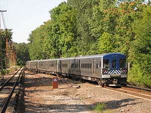
On the electrified portions of the line, M3As and M7As are usually used. As with the Hudson Line, diesel-powered trains are driven by dual-mode Genesis and BL20-GH locomotives, paired with Shoreliner coaches. While some peak-period trains operate directly to and from Grand Central Terminal, most Harlem Line diesel-only territory is operated as shuttle service between Southeast (where electrification ends) and Wassaic, 29 miles (47 km) north in Dutchess County.
Stations
Main line
| Zone | Station | Miles (km) from GCT[73] |
Date opened |
Date closed |
Connections / notes |
|---|---|---|---|---|---|
| 1 | Grand Central Terminal |
0.0 (0.0) | October 6, 1871[74] | Originally Grand Central Depot, then Grand Central Station | |
| 59th Street | |||||
| 72nd Street | |||||
| 86th Street | May 15, 1876[15] | c. 1903[75] | |||
| 110th Street | 3.43 (5.52) | May 15, 1876[15] | June 1, 1906 | ||
| Harlem–125th Street |
4.2 (6.8) | 1897[76] | |||
| Manhattan/Bronx border | |||||
| 2 | |||||
| 138th Street | 5.0 (8.0) | 1886[77] | 1972[63] | Also named Mott Haven and The Bronx | |
| Hudson Line diverges | |||||
| Melrose | 6.1 (9.8) | c. 1890[78] | |||
| Morrisania | 6.7 (10.8) | c. 1858[79] | 1972[63] | ||
| Claremont Park | 7.2 (11.6) | c. 1960[76][63] | |||
| Tremont | 7.8 (12.6) | c. 1890[78] | |||
| 183rd Street | 8.5 (13.7) | 1972[63] | |||
| Fordham |
8.9 (14.3) | ||||
| Botanical Garden |
9.5 (15.2) | 1893[80] | Originally Bedford Park | ||
| Former Jerome Park Branch diverges (1880-1906) | |||||
| Williams Bridge | 10.5 (16.9) | c. 1842 | |||
| Woodlawn | 11.8 (19.0) | 1848 | |||
| New Haven Line diverges | |||||
| Wakefield | 12.6 (20.3) | Originally Washingtonville | |||
| Bronx / Westchester County border | |||||
| 3 | Mount Vernon West |
13.1 (21.1) | 1914[81] | Originally Mount Vernon | |
| Fleetwood |
14.3 (23.0) | October 25, 1924[82] | |||
| Bronxville |
15.3 (24.6) | 1916[63][81] | |||
| Tuckahoe |
16.0 (25.7) | 1844 | |||
| Crestwood |
16.8 (27.0) | 1901 | Originally Yonkers Park | ||
| 4 | Scarsdale |
18.9 (30.4) | 1846[83] | ||
| Hartsdale |
20.6 (33.2) | 1915[81] | Originally Hart's Corner | ||
| White Plains |
22.4 (36.0) | 1844 | |||
| Holland Avenue | 1972[63] | ||||
| North White Plains |
24.0 (38.6) | 1972[63] | |||
| 5 | Valhalla |
25.4 (40.9) | 1846 | Originally Davis Brook, then Kensico | |
| Kensico Cemetery | 26.4 (42.5) | 1983[63] | |||
| Mount Pleasant | 27.2 (43.8) | Originally Mount Pleasant and Fairlawn | |||
| Hawthorne |
28.2 (45.4) | 1847 | Originally Unionville | ||
| Thornwood | 29.4 (47.3) | c. 1891 | March 5, 1984[84] | Originally Sherman Park | |
| Pleasantville |
30.5 (49.1) | c. 1846[85] | |||
| Chappaqua |
32.4 (52.1) | 1902[79] | |||
| 6 | Mount Kisco |
36.7 (59.1) | c. 1858[79] | ||
| Bedford Hills |
39.1 (62.9) | Originally Bedford | |||
| Katonah |
41.1 (66.1) | April 5, 1897[86] | |||
| Former Lake Mahopac Branch diverges | |||||
| Golden's Bridge |
43.6 (70.2) | ||||
| 7 | Purdy's |
46.1 (74.2) | |||
| Croton Falls |
47.8 (76.9) | 1847 | |||
| Westchester County / Putnam County border | |||||
| Brewster |
52.0 (83.7) | 1848[87] | |||
| Former Putnam Branch and Lake Mahopac Branch converge | |||||
| Southeast |
53.2 (85.6) | 1980 | Terminus of electrification Formerly Brewster North | ||
| Dykeman's | 54.7 (88.0) | c. 1848 | c. 1968 | ||
| Towner's | 57.9 (93.2) | c. 1850 | c. 1968 | ||
| 8 | Patterson |
60.2 (96.9) | |||
| Putnam County / Dutchess County border | |||||
| Pawling |
63.8 (102.7) | ||||
| Appalachian Trail | 65.9 (106.0) | 1991[88] | |||
| 9 | Harlem Valley–Wingdale |
69.0 (111.0) | c. 1930's | Formerly State Hospital | |
| Wingdale | 69.8 (112.3)[63] | c. 1977 | Originally Wing's, then South Dover | ||
| Dover Furnace | 72.5 (116.7)[63] | c. 1968 | |||
| Dover Plains |
76.7 (123.4) | c. 1850 | |||
| 10 | Tenmile River |
80.0 (128.7) | 1857 | Formerly State School | |
| Wassaic |
81.4 (131.0) | c. 1848 | Closed from March 22, 1972 until July 9, 2000 | ||
| Tracks north of Wassaic were abandoned by Conrail between 1979 and 1983 | |||||
| Amenia | 84.8 (136.5) | c. 1848 | March 27, 1980 | ||
| 12 | Sharon | 87.8 (141.3) | 1873[63] | March 27, 1980 | |
| Coleman's | 89.0 (143.2) | 1851[63] | March 27, 1980 | ||
| Millerton | 92.7 (149.2) | c. 1848 | March 27, 1980 | ||
| Mount Riga | 95.9 (154.3) | c. 1848 | April 1, 1976 | ||
| Dutchess County / Columbia County border | |||||
| Boston Corners | 99.8 (160.6) | March 27, 1976 | |||
| Copake Falls | 104.8 (168.7) | 1976 | Originally Copake Iron Works | ||
| Hillsdale | 108.9 (175.3) | March 27, 1976 | |||
| Craryville | 111.7 (179.8) | c. 1849 | March 27, 1976 | ||
| Martindale | 115.5 (185.9) | c. 1848 | March 27, 1976 | ||
| Philmont | 118.9 (191.3) | January 1852 | March 27, 1976 | ||
| Ghent | 124.9 (201.0) | c. 1846 | March 27, 1980 | Junction with Boston and Albany Railroad Hudson Branch | |
| Chatham–Union Station | 127.5 (205.2) | December 21, 1841 | March 1976 | Junction with Boston and Albany Railroad Main Line and Rutland Railroad | |
Lake Mahopac Branch
Built by the New York and Mahopac Railroad in 1871; The entire branch was abandoned on April 2, 1959.[89]
| Station | Miles (km) from GCT |
Date opened |
Date closed |
Connections / notes |
|---|---|---|---|---|
| Katonah |
41.2 (66.3) | April 5, 1897[86] | ||
| Harlem Line diverges | ||||
| Lincolndale[81] | ||||
| Westchester County / Putnam County border | ||||
| Lake Mahopac[90] | ||||
| Putnam Division diverges | ||||
| Mahopac | ||||
| Crafts | ||||
| Carmel | ||||
| Tilly Foster | Originally built for the Tilly Foster Mine which closed in 1897. Station continued to operate. | |||
| Harlem Line converges at Putnam Junction | ||||
| Brewster |
51.9 (83.5) | 1848[87] | ||
Port Morris Branch
The entire line was in the Bronx, used exclusively for freight,[13] and formally abandoned in 2004.
| Station | Miles (km) from GCT |
Date opened |
Date closed |
Connections / notes |
|---|---|---|---|---|
| Melrose | 6.1 (9.8) | c. 1890[78] | ||
| Harlem Line diverges | ||||
| Westchester Avenue[67] | Freight only | |||
| West Junction with Oak Point Yard | ||||
| Bridge under Harlem River and Port Chester Railroad (NH) | ||||
| East Junction with Oak Point Yard | ||||
| Port Morris[67] | Freight only | |||
References
- ↑ Moser, Emily (September 21, 2012). "The Harlem Line, and the color blue". I Ride The Harlem Line... Retrieved June 19, 2017.
- 1 2 3 4 5 6 7 8 9 10 11 12 13 14 15 Wassaic Extension Project: Environmental Impact Statement. Metropolitan Transportation Authority. August 1997.
- 1 2 3 Rowe, Claudia (July 9, 2000). "ROAD AND RAIL; 6 Miles for $6 Million". The New York Times. ISSN 0362-4331. Retrieved June 19, 2017.
- 1 2 Ames, Lynn (March 31, 1996). "The View From: Dover Plains;With Riders of the 6:33: A Train Like No Other". The New York Times. Retrieved June 13, 2018.
- 1 2 3 4 5 6 7 8 9 10 11 Hyatt, Elijah Clarence (1898). History of the New York & Harlem Railroad. Retrieved June 21, 2017.
- 1 2 3 4 5 6 7 8 9 Grogan, Louis V. (1989). The Coming of the New York and Harlem Railroad. Louis V. Grogan. ISBN 0962120650.
- 1 2 The Financial Limitations Of Our Fore-Fathers. Railroad Branch of the Young Men's Christian Association of the City of New York. 1901. pp. 350–352.
- ↑ Meyers, Stephen L. (2005). Manhattan's Lost Streetcars. Arcadia Publishing. ISBN 9780738538846.
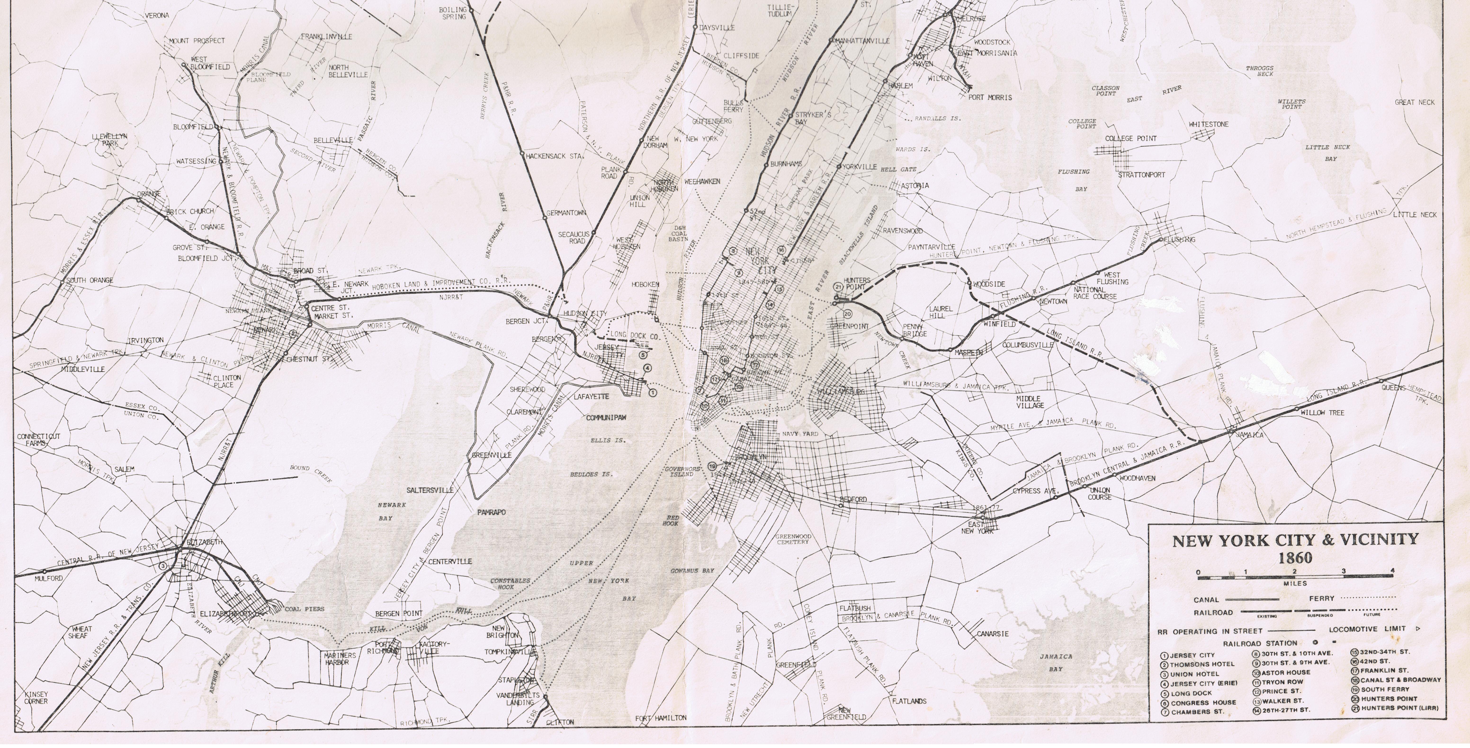
- ↑ "New York City and Vicinity Map". brooklynrail.net. 1860. Retrieved June 20, 2017.
- ↑ The Official Guide of the Railways and Steam Navigation Lines of the United States, Porto Rico, Canada, Mexico and Cuba. National Railway Publication Company. 1907. pp. 226, 310.
- ↑ "Central New England Railroad and Connections Map". Wikimedia Commons. Central New England Railroad. 1901. Retrieved June 20, 2017.
- 1 2 "The Harlem Division". New York Central Historical Society. October 15, 2008. Retrieved June 20, 2017.
- 1 2 Anastasio, Joe (December 23, 2009). "Port Morris Branch: The so-called Bronx Swamp". LTV Squad. Retrieved June 20, 2017.
- 1 2 "RAILROAD ENGINEERING IN HARLEM.; Progress of the Work of Elevating the Central's Tracks in Park Avenue" (PDF). The New York Times. August 23, 1894. ISSN 0362-4331. Retrieved June 21, 2017.
- 1 2 3 "PARTIAL RAPID TRANSIT.; FROM THE GRAND CENTRAL DEPOT. ARRANGEMENTS FOR QUICK TRAINS ON THE HARLEM ROAD TRAINS TO RUN NEXT MONDAY FARES, TIME, RATES OF COMMUTATION, &C" (PDF). The New York Times. May 12, 1876. ISSN 0362-4331. Retrieved June 21, 2017.
- ↑ "RAPID TRANSIT TO AND FROM HARLEM" (PDF). The New York Times. April 13, 1876. ISSN 0362-4331. Retrieved June 21, 2017.
- ↑ "TO RAISE THE CENTRAL'S TRACKS.; The Park Avenue Improvement and the New Harlem Drawbridge" (PDF). The New York Times. April 24, 1893. Retrieved June 21, 2017.
- ↑ "A NEW RAILROAD STATION.; To be Opened Soon at 125th Street by the Central and Harlem River Roads" (PDF). The New York Times. October 8, 1897. ISSN 0362-4331. Retrieved June 21, 2017.
- ↑ Grogan, Louis (1990). The coming of the New York and Harlem Railroad. National Railway Historical Society.
- ↑ "EXTENDS ITS ELECTRIC ZONE.; Harlem Division Laying Third Rail Between Mt. Vernon and White Plains". The New York Times. October 10, 1909. ISSN 0362-4331. Retrieved June 23, 2017.
- 1 2 3 Marks, George V.; Lall, Bhagirath; Committee, American Society of Civil Engineers Public Transport (October 1, 1985). Organization and management of public transport projects: proceedings of the specialty conference. The Society. ISBN 9780872624580.
- ↑ "ELECTRIC TRAINS TO WHITE PLAINS MCH. 15; New Service and New Cars on Harlem Division of New York Central" (PDF). The New York Times. March 6, 1910. ISSN 0362-4331. Retrieved June 23, 2017.
- ↑ "TO CONSIDER CROSSING PLAN; State Commission Will Take Up Amenia Project This Year" (PDF). The New York Times. October 19, 1930. ISSN 0362-4331. Retrieved June 23, 2017.
- ↑ Folsom, Merrill (September 12, 1952). "DIESELS TAKE OVER N. Y. CENTRAL RUNS; Last Iron Horse Hauls Train on the Harlem Division -- Old-Timers Are Sad". The New York Times. ISSN 0362-4331. Retrieved June 23, 2017.
- ↑ Williams, Gray (2006). New Castle: Chappaqua and Millwood. Arcadia Publishing. ISBN 9780738539287.
- ↑ "WESTCHESTER SET FOR TWO BIG JOBS; State Opens Bids Dec.20 for Pleasantville Crossing and New Expressway Work". The New York Times. November 24, 1956. ISSN 0362-4331. Retrieved June 23, 2017.
- ↑ "N.Y. CENTRAL TOLD TO MAINTAIN RUNS; Cut on Harlem Division Held in Abeyance Pending P.S.C. Hearing on Aug. 19" (PDF). The New York Times. August 12, 1960. ISSN 0362-4331. Retrieved June 23, 2017.
- ↑ "2-Way Radio Gets Test For Commuter Trains" (PDF). The New York Times. November 14, 1961. ISSN 0362-4331. Retrieved June 23, 2017.
- ↑ "Zone Fare Proposal Of the N.Y. Central Approved by State". The New York Times. January 11, 1964. ISSN 0362-4331. Retrieved June 23, 2017.
- ↑ "Passenger Runs to Chatham On Penn Central End Today". The New York Times. August 1, 1971. ISSN 0362-4331. Retrieved June 23, 2017.
- 1 2 3 Faber, Harold (March 26, 1972). "Train Service to Upper Harlem Valley Terminated". The New York Times. p. 60. Retrieved July 3, 2011.
- ↑ Baer, Christopher (April 2015). "A GENERAL CHRONOLOGY OF THE PENNSYLVANIA RAILROAD COMPANY ITS PREDECESSORS AND SUCCESSORS AND ITS HISTORICAL CONTEXT" (PDF). prrths.com. Retrieved June 20, 2017.
- 1 2 3 Baer, Christopher (2015). "A GENERAL CHRONOLOGY OF THE SUCCESSORS OF THE PENNSYLVANIA RAILROAD COMPANY AND THEIR HISTORICAL CONTEXT" (PDF). prrths.com. Retrieved June 19, 2017.
- 1 2 Empire State Report. New York State Legislative Institute at Baruch College/CUNY. 1981.
- ↑ 1968-1973, the Ten-year Program at the Halfway Mark. Metropolitan Transportation Authority. 1973.
- ↑ Greenhouse, Linda (March 4, 1971). "Harlem Division Testing Ends" (PDF). The New York Times. ISSN 0362-4331. Retrieved June 23, 2017.
- ↑ "New Platforms Due At 11 City Stations On the Penn Central". The New York Times. September 11, 1974. p. 40. Retrieved June 15, 2018.
- ↑ "New Commuter Cars Make Debut for M.T.A. in Bronx". The New York Times. March 15, 1975. p. 13. Retrieved June 15, 2018.
- 1 2 "Upper Harlem Line To Be Electrified". The Harlem Valley Times. February 5, 1981. p. 7. Retrieved June 15, 2018.
- ↑ Roddy, Michael (November 26, 1980). "MTA outlines plan to rebuild rail lines". Gannett Westchester Newspapers. p. 2. Retrieved June 15, 2018.
- 1 2 Hudson, Edward (January 1, 1984). "Electrification Project Nears Completion on Harlem Line". The New York Times. Retrieved July 3, 2011.
- ↑ Pollak, Michael (June 23, 1996). "For Hikers, The Train To the Trail". New York Times. Retrieved February 21, 2010.
- ↑ Pollak, Michael (June 23, 1996). "For Hikers, The Train To the Trail". The New York Times. Retrieved June 13, 2018.
- ↑ Steinberg, Jacques (March 13, 1993). "Village Woos Train to Prosperity". The New York Times. Retrieved June 13, 2018.
- ↑ Viggiani, Bryan (October 19, 1995). "Town board backs Metro-North Railroad". The Harlem Valley Times. Retrieved June 3, 2018.
- ↑ "MTA releases new station stop names". The Register Herald. July 16, 1998. Retrieved June 3, 2018.
- ↑ "Forecast of MTA Capital Program Contracts January - June 1999". mta.nyc.ny.us. June 1999. Archived from the original on May 8, 1999. Retrieved June 3, 2018.
- ↑ "MTA Metro-North Railroad To Open New Train Station in New York City To Serve Southwest Bronx and Yankee Stadium". www.mta.info. Metropolitan Transportation Authority. May 21, 2009. Retrieved June 19, 2017.
- ↑ "LAYING TRACK FOR REGION'S FUTURE". NY Daily News. July 10, 2000. Retrieved June 20, 2017.
- ↑ Mcdowell, Edwin (October 1, 2000). "Location, Location, Commutation". The New York Times. ISSN 0362-4331. Retrieved June 19, 2017.
- ↑ "Introducing Metro-North's new Wassaic and Tenmile River Train Stations Service begins July 9th" (PDF). Fulton History. Metropolitan Transportation Authority in The Register Herald. July 6, 2000. Retrieved June 19, 2017.
- ↑ Brenner, Elsa (July 24, 1994). "Rail Proposal Pits Backyards vs. Trains". The New York Times. Retrieved June 13, 2018.
- ↑ Schreibman, Lisa (June 17, 1999). "Testimony in Support of Metro-North Railroad Mid-Harlem Line Third Track Project DEIS Presented by Lisa Schreibman of the Tri-State Transportation Campaign June 17, 1999" (PDF). tstc.org. Retrieved June 21, 2017.
- ↑ Demarco, Peter (August 27, 2001). "$57M FOR METRO-NORTH HARLEM LINE". NY Daily News. Retrieved June 21, 2017.
- ↑ "How the Long Island Rail Road Could Shape the Next Economy" (PDF). rauchfoundation.org. Regional Plan Association. 2013. pp. 11–12. Retrieved June 21, 2017.
- ↑ Egbert, Bill (July 21, 2005). "RAIL LINE UPGRADE BOOSTING RIDERSHIP". NY Daily News. Retrieved June 21, 2017.
- ↑ Rosendale, Gus; Beckford, Checkey; Siff, Andrew; Kim, Michelle (February 4, 2015). "6 Die When Packed Metro-North Train Hits Car on Tracks, Sparking Fiery Crash: Officials". NBC 4 New York. Retrieved June 20, 2017.
- ↑ Tangel, Andrew (February 3, 2015). "Metro-North Train Crashes into Vehicle in Valhalla, N.Y." The Wall Street Journal. New York, New York. Retrieved February 4, 2015.
- ↑ Moser, Emily (August 4, 2012). "Chatting with Howard Permut, President of Metro-North Railroad". I Ride The Harlem Line... Retrieved June 21, 2017.
- ↑ "Getting on Track Working with Railroads to Build Trails in New York State". railstotrails.org. p. 15. Retrieved June 21, 2017.
- ↑ "MTA Twenty-Year Capital Needs Assessment 2015-2034" (PDF). mta.info. Metropolitan Transportation Authority. October 2013. Retrieved June 21, 2017.
- ↑ Haviland, Pierce (November 10, 2010). "New York Central: Putnam Division". www.piercehaviland.com. Retrieved June 20, 2017.
- 1 2 3 4 5 6 7 8 9 10 11 12 13 Darlington, Peggy; Donch, Mary (May 7, 2013). "Metro North Harlem Line". stationreporter.net. Archived from the original on November 29, 2014. Retrieved June 20, 2017.
- ↑ Lombardi, Kate Stone (February 5, 1995). "Metro-North Buys A Line for Future". The New York Times. ISSN 0362-4331. Retrieved June 20, 2017.
- ↑ "Beacon Line Feasibility Study" (PDF). October 20, 2000. Retrieved June 21, 2017.
- ↑ Port Morris Branch Tunnel. Railroad Gazette. November 10, 1905. pp. 436–437.
- 1 2 3 "New York Central Map of New York City" (PDF). canadasouthern.com. New York Central Railroad Map. 1921. Retrieved June 20, 2017.
- ↑ http://www.nyc.gov/html/dcp/pdf/transportation/deck03c.pdf
- ↑ Halbfinger, David M. (October 12, 1998). "20 Years in the Making, Rail Freight Link Opens in Bronx". The New York Times. Retrieved January 30, 2008.
- ↑ "2009 New York State Rail Plan" (PDF). 2009. p. 51. Retrieved June 21, 2017.
- ↑ Circumferential Subway route Michaelminn.net
- ↑ "33422 - Decision". Archived from the original on June 15, 2011. Retrieved November 5, 2015.
- ↑ "New York Central And Hudson River Railroad Harlem Division Time Table No. 3 For Employes Only Taking Effect At 12.01 A.M. Sunday, June 18, 1905" (PDF). canadasouthern.com. June 18, 1905. Retrieved June 12, 2018.
- ↑ "The Grand Central Railroad Depot, Harlem Railroad". The New York Times. October 1, 1871. p. 6. Retrieved July 4, 2011.
- ↑ Brennan, Joseph (2002). "Abandoned Stations : 86 St (Park Ave)". www.columbia.edu. Retrieved June 20, 2017.
- 1 2 Brennan, Joseph (2002). "Abandoned Stations : Bronx Railroad Stations". www.columbia.edu. Retrieved June 20, 2017.
- ↑ Testagrose, Joe (May 21, 1972). "Penn Central MNRR ACMU 1044 138th Street". nycsubway.org. Retrieved June 20, 2017.
- 1 2 3 Moser, Emily (September 23, 2011). "Melrose Station, in the late 1800s". I Ride The Harlem Line. Retrieved June 20, 2017.
- 1 2 3 "New York and Harlem Railroad Map". 1858. Retrieved June 20, 2017 – via I Ride the Harlem Line.
- ↑ "time Traveling on Mosholu Pkwy". Time Traveling on Mosholu Pkwy. Retrieved June 20, 2017.
- 1 2 3 4 "Existing Stations in Westchester County". ny.existingstations.com. January 1, 2009. Retrieved June 20, 2017.
- ↑ "Historic American Buildings Survey (Fleetwood Railroad Station; Page 4)". loc.gov. Retrieved June 20, 2017.
- ↑ Moser, Emily (November 2, 2010). "Tuesday Tour of the Harlem Line; Scarsdale Station". I Ride The Harlem Line. Retrieved June 20, 2017.
- ↑ Walzer, E.B. (March 5, 1984). "The Train Doesn't Stop Here Anymore" (PDF). The Herald-Statesman. Retrieved December 31, 2017.
- ↑ Grogan, Louis V. (1989). The Coming of the New York and Harlem Railroad. Self-Published. p. 14. ISBN 0-962120-65-0.
- 1 2 Singer, Penny (March 30, 1997). "Katonah to Observe 100 Years of Rebirth". The New York Times. Retrieved February 21, 2010.
- 1 2 "Brewster Railroad History". www.southeastmuseum.org. c. 1997. Retrieved June 20, 2017.
- ↑ Pollak, Michael (June 23, 1996). "For Hikers, The Train To the Trail". New York Times. Retrieved February 21, 2010.
- ↑ "N.Y.C.R.R. Ceases To Operate At Mahopac" (PDF). The Putnam County Courier. March 26, 1959. Retrieved May 18, 2018.
- ↑ "Existing Stations in Putnam County". ny.existingstations.com. September 19, 2007. Retrieved June 20, 2017.
External links
| Wikimedia Commons has media related to Harlem Line. |
| East of Hudson | 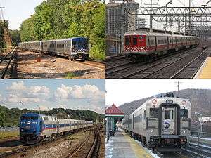 | |
|---|---|---|
| West of Hudson (operated by NJ Transit) | ||
| Non-revenue and Predecessor lines | ||
| Other | ||