Kalabaka
| Kalabaka Καλαμπάκα | |
|---|---|
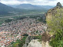 The town of Kalabaka as seen from Meteora. | |
 Kalabaka Location within the region 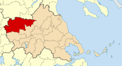 | |
| Coordinates: 39°42′N 21°38′E / 39.700°N 21.633°ECoordinates: 39°42′N 21°38′E / 39.700°N 21.633°E | |
| Country | Greece |
| Administrative region | Thessaly |
| Regional unit | Trikala |
| Area | |
| • Municipality | 1,658.3 km2 (640.3 sq mi) |
| • Municipal unit | 277.1 km2 (107.0 sq mi) |
| Population (2011)[1] | |
| • Municipality | 21,991 |
| • Municipality density | 13/km2 (34/sq mi) |
| • Municipal unit | 12,000 |
| • Municipal unit density | 43/km2 (110/sq mi) |
| Community[1] | |
| • Population | 8,619 (2011) |
| Time zone | UTC+2 (EET) |
| • Summer (DST) | UTC+3 (EEST) |
| Vehicle registration | ΤΚ |
| Website | http://www.kalabaka.org/ |
Kalabaka (Greek: Καλαμπάκα, Kalabáka, alternative transliterations are Kalambaka and Kalampaka) is a town and a municipality in the Trikala regional unit, part of Thessaly in Greece. The population was 21,991 at the 2011 census, of which 8,330 in the town proper.[1] The Metéora monasteries are located in the town. Kalabaka is the northwestern terminal of the old Thessaly Railways, now part of OSE.
History
In 1995, an ancient tomb was found in Kalabaka dating from the 20th century BC. A Greek inscription on the wall of one of the town’s oldest churches (Saint John the Baptist) testifies to the existence of an ancient Greek settlement under the name Aiginion.

In the 10th century AD, it was known as Stagoi (Στάγοι), a Byzantine fortress and bishopric. Of its medieval monuments, only the cathedral, the Church of the Dormition, survives. It was a late 11th- or early 12th-century building, built on the remains of an earlier, late antique church.[2] Relics of an ancient Greek temple – probably of god Apollo – have been incorporated in the wall of the town’s oldest and most renowned church, dedicated to Virgin Mary.
Stagoi is first mentioned in Diatyposis written by the Byzantine Emperor Leo VI the Wise (886-812). In 1163 there was a reference to the castle of Stagoi. In 1204 Stagoi fell under the Despotate of Epirus. At the end of the 13th century they fell under the Duchy of Neopatria. In 1334, they were taken over once more by the Despot of Epirus, John II Orsini, and shortly thereafter they came once more under the control of the Byzantine Empire. In 1348, they were conquered by the Serbs of Stephen Dushan. They reached their peak under the rule of his brother, King Simeon Uroš. When the Turks conquered Thessaly, Kalabaka was placed under the administrative rule of the Pasha of Larisa and later on of the Sanjak of Trikala.
It was named "Kalabaka" six or seven centuries ago. It is of Turkish origin and means "powerful fortress". It has been Anglicized variously as Kalampaka, Kalambaka, Kalabaki, and Kalabak.
Bishopric
From the beginning of the 10th century, Stagoi was referred to as an episcopal see, thereby enjoying privileges and donations from the Byzantine emperors throughout the Middle Ages. It owned significant stretches of land and had dependent farmers in neighboring settlements. Besides the fields of northwest Thessaly, its territory included an extensive mountainous zone in Asia and central Pindos. The bishopric of Stagoi, a suffragan of the Metropolis of Larissa, was maintained, with some small intermissions, up to 1900 when it was merged with the bishopric of Tricca to form the Metropolis of Tricca and Stagoi with the town of Trikala as its seat. It was reestablished in 1991, and has been operating ever since as the Metropolis of "Stagoi and Meteora" with its seat in the town of Kalabaka.
Province
The province of Kalabaka (Greek: Επαρχία Καλαμπάκας) was one of the provinces of the Trikala Prefecture. It had the same territory as the present municipality.[3] It was abolished in 2006.
Transport
The city is served by Kalambaka station on the Palaiofarsalos-Kalambaka line.
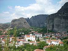
Geography
The town is situated at the foot of the Meteora peaks. It is inhabited by an important community of Aromanians (Vlachs) who are the custodians of the Meteora monasteries where they walk or drive up to the rock mountains to worship their Greek Orthodox faith.
Government
The municipality Kalabaka was formed at the 2011 local government reform by the merger of the following 8 former municipalities, that became municipal units:[4]
The municipality has an area of 1,658.280 km2, the municipal unit 277.087 km2.[5] The municipal unit Kalabaka (which corresponds with the municipality as it existed between 1997 and 2010) consists of the following communities (constituent settlements in brackets):
- Avra (Avra, Nea Zoi)
- Diava (Diava, Koromilia)
- Kalabaka (Kalabaka, Agia Paraskevi, Vitoumas)
- Kastraki
- Krya Vrysi (Krya Vrysi, Trifyllia)
- Megali Kerasea (Megali Kerasea, Mourgkani)
- Orthovouni
- Sarakina
- Vlachava
Twin town
Kalampaka has two twin towns:
- Schwabach, Germany
- Le Haillan, France
Recent recognition
Kalabaka was voted as one of the most beautiful places in Greece by the Skai TV show I LOVE GR.[6]
Notable people
- Kostas Fortounis, professional footballer who was born in nearby Trikala but he and his family are from Kalabaka.
- Christos Almpanis, professional footballer who was born in the town.
References
| Wikimedia Commons has media related to Kalambaka. |
- 1 2 3 "Απογραφή Πληθυσμού - Κατοικιών 2011. ΜΟΝΙΜΟΣ Πληθυσμός" (in Greek). Hellenic Statistical Authority.
- ↑ Kazhdan, Alexander, ed. (1991), Oxford Dictionary of Byzantium, Oxford University Press, p. 1941, ISBN 978-0-19-504652-6
- ↑ "Detailed census results 1991" (PDF). Archived from the original (PDF) on 3 March 2016. (39 MB) (in Greek) (in French)
- ↑ Kallikratis law, Ministry of the Interior (Greece) (in Greek)
- ↑ "Population & housing census 2001 (incl. area and average elevation)" (PDF) (in Greek). National Statistical Service of Greece. Archived from the original (PDF) on 21 September 2015.
- ↑ "Archived copy". Archived from the original on 24 December 2009. Retrieved 23 January 2010.
Sources
- Richard Stillwell, William L. MacDonald, Marian Holland McAllister, Stillwell, Richard, MacDonald, William L., McAlister, Marian Holland, Aiginion, in The Princeton Encyclopedia of Classical Sites.
- A. Avramea, I Vyzantini Thessalia mechri tou 1204 [Byzantine Thessaly up to 1204], doctoral dissertation, Athens 1974, EKPA-Vivliothiki Sofias N. Saripolou 27, Athens 1974, pp. 158–161.
- V. Spanos, Istoria-Prosopographia tis BD. Thessalias to B’ miso tou ID’ aiona. [History-Portrait of NW Thessaly the 2nd half of the 14th c.], Larisa 1995
- I. Vogiatzidis, To chronikon ton Meteoron [The Chronicle of Meteora], Yearbook of Society for Byzantine Studies 2 (1925), pp. 149–162.
- D. Sofianos, Acta Stagorum, Ta yper tis Thessalikis episkopis Stagon palaia vyzantina eggrafa (ton eton 1163, 1336 kai 1393) [Acta Stagorum: the Byzantine documents for the Thessalic diocese of Stagai [from the years 1163, 1336 and 1393)], Trikalina 13 (1993), pp. 7–67.
- St. Aristarchis, "Ekthesis epi ton diagonismaton Thessalias kai Epirou", [Report on the examinations in Epirus and Thessaly] O en Konstantinoupolei Ellinikos Filologikos Syllogos 13-15 (1867), pp. 31–39
- L. Heuzey – H.Daumet, Mission arhéologique de Macédoine, Paris 1876, pp. 452–454,
- L.Heuzey, Odoiporiko stin Tourkokratoumeni Thessalia to 1858 [Excursion dans la Thessalie turque en 1858], transl. Ch. Dimitropoulos, publ. Afoi Kyriakidi, Thessaloniki 1991, pp. 152–157
- F. Dölger, Regesten der kaiserurkunden des oströmischen reiches von 565-1453,Verlag, München-Berlin 1960,pp. 159–160.
- P.Sustal, Hellas und Thessalia, (TIB 1), ed Η. Hunger., Österreichischen Akademie der Wissenschaften, Bonn 1976, p. 262.
- Ch. Astruc, Un document inédit de 1163 sur l’ évêché thessalien, de Stagi, Paris.Suppl. Gr. 1371, BCH, vol. 83(1959),pp. 206–246
External links
- Natural History Museum of Meteora and Mushroom Museum | Kalambaka's Museum
- Holy Metropolis of Stagon and Meteoron
- Official site of the Metéora Monasteries
- News from Kalampaka and the surrounding area
- The Radio of Kalampaka
Administrative division of the Thessaly Region | ||
|---|---|---|
| Regional unit of Karditsa | 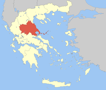 | |
| Regional unit of Larissa | ||
| Regional unit of Magnesia | ||
| Regional unit of the Sporades | ||
| Regional unit of Trikala | ||
| ||