Pella (regional unit)
| Pella Περιφερειακή ενότητα Πέλλας | |
|---|---|
| Regional unit | |
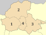 Municipalities of Pella | |
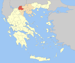 Pella within Greece | |
| Coordinates: 40°55′N 22°05′E / 40.917°N 22.083°ECoordinates: 40°55′N 22°05′E / 40.917°N 22.083°E | |
| Country | Greece |
| Region | Central Macedonia |
| Capital | Edessa |
| Government | |
| • Vice Governor | Theodoros Theodoridis |
| Area | |
| • Total | 2,506 km2 (968 sq mi) |
| Population (2011) | |
| • Total | 139,680 |
| • Density | 56/km2 (140/sq mi) |
| Time zone | UTC+2 |
| • Summer (DST) | UTC+3 (EEST) |
| Postal codes | 58x xx |
| Area codes | 238x0 |
| ISO 3166 code | GR-59 |
| Car plates | ΕΕ |
| Website |
www |
Pella (Greek: Περιφερειακή ενότητα Πέλλας) is one of the regional units of Greece, in the geographic region of Macedonia. It is part of the Region of Central Macedonia. It is named after the ancient city of Pella, the capital of ancient Macedonia and the birthplace of Alexander the Great.[1] The capital of Pella is Edessa with a population of 19,036 inhabitants according to the census of 2011, while the largest city and industrial and commercial center is Giannitsa with 29,789 inhabitants. Other centers are the towns Krya Vrisi, Aridaia and Skydra.
Administration
The regional unit Pella is subdivided into 4 municipalities. These are:[2]
Prefecture
_in_Pella_city_(6914694770).jpg)
The region covers an area of 2.505,8 Km2 the majority of which is covered by arable land, forests and pastures. The mountains that surround the county is Mount Vora (2,524 m), Mount Vermion (2,027 m), mount Paiko (1,458 m), Mount Jenna (2,182 m) and Mount Pinovo (2,154 m). The main plains of the prefecture is plain of Pozar in the north and the vast plain of Giannitsà in the southeastern part of the county. Natural features of the area include the mountains, lakes Vegoritida and Agra, and rivers Loudias and Edessian. The county has surface and groundwater resources. There are a number of archaeological sites in the area.
Administratively, the Pella divided into 4 municipalities (Kallikratis). The population is according to the latest census of the Hellenic Statistical Authority (2011) to 139,680 inhabitants...[2]
| New municipality | Old municipalities | Seat |
|---|---|---|
| Almopia | Aridaia | Aridaia |
| Exaplatanos | ||
| Edessa | Edessa | Edessa |
| Vegoritida | ||
| Pella | Pella | Giannitsa |
| Giannitsa | ||
| Krya Vrysi | ||
| Kyrros | ||
| Megas Alexandros | ||
| Skydra | Skydra | Skydra |
| Meniida |
Provinces
| Provinces of Pella Prefecture | Seat (if different) |
|---|---|
| Province of Almopia | Aridaia |
| Province of Edessa | |
| Province of Giannitsa |
Note: Provinces no longer hold any legal status in Greece.
Geography
The mountains lie to the north and the southwest, including the Vermio mountains, the Voras mountains to the northwest and the Paiko mountains to the northeast. The southernmost portion is flat and in the ancient times, it was a gulf connected with the Aegean Sea, the elevation does not exceed about 5 to 10 m (16 to 33 ft) above sea level. Pella is bounded by the prefectures of Kilkis to the northeast, Thessaloniki to the east, Imathia to the south, Kozani to the southwest, by Lake Vegoritida to the southwest, and by Florina to the west. On the north, it is bounded by the national border between Greece and the Republic of Macedonia.
Tourism and sightseeing
.jpg)

- Ancient Pella and Archaeological Museum of Pella: The capital of ancient Macedonia and birthplace of Alexander the Great and King Phillip II left a number of archaeological findings which are now housed in the Palace and the New Museum.
- Loudias River: A river 7 km from Giannitsa has a canoe, kayak and rowing center
- Waterfalls in the city of Edessa
- Pozar thermal baths: The hot springs are located in a mountainous area (altitude 360–390 m) and occupy an area of 75 acres. Five spa gush along the warm river, which continues to flow in the basin of Almopia. Near the baths is the gorge of Baths, Folk - Paleontological Museum, Caves, The Black forest
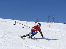
- Kaimaktsalan ski resort: Mount Kaimaktsalan or Vorras is the third largest in height mount in Greece (altitude 2,524 m). There is a ski area with 16 ski slopes. At the foot of the mountain there is the village of Agios Athanasios.
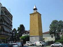
- Giannitsa Ottoman monuments: At the city of Giannitsa there are a lot of buildings from the Ottoman period like the Clock Tower, Mausoleum and baths of Gazi Evrenos, House of Emin Bey, The Baths and the mausoleum of Ahmet Bey, Mosque of Sheikh Ilachi, Mosque of Iskender Bey.
History
In antiquity, the area around the modern Pella regional unit was part of the ancient Greek Kingdom of Macedon. It later became part of the Roman Empire and later the Byzantine and the Ottoman Empires. Following approximately 500 years of Ottoman rule, it rejoined Greece in 1913, following the Balkan Wars.
Agriculture
The southern part of the regional unit has a number of orchards. Agriculture once represented its main industry, today, manufacturing, services and other businesses dominates about 70% of its industry.
Transport
See also
References
- ↑ Law, Gwillim (1999). Administrative subdivisions of countries: a comprehensive world reference, 1900 through 1998. McFarland. p. 152. ISBN 978-0-7864-0729-3.
- 1 2 "Kallikratis reform law text" (PDF).
Administrative division of the Central Macedonia Region | ||
|---|---|---|
| ||
| Regional unit of Chalkidiki |  | |
| Regional unit of Imathia | ||
| Regional unit of Kilkis | ||
| Regional unit of Pella | ||
| Regional unit of Pieria | ||
| Regional unit of Serres | ||
| Regional unit of Thessaloniki | ||
| ||