Corfu (regional unit)
| Corfu Περιφερειακή ενότητα Κερκύρας | |
|---|---|
| Regional unit | |
 Municipalities of Corfu | |
 Corfu within Greece | |
| Coordinates: 39°40′N 19°45′E / 39.667°N 19.750°ECoordinates: 39°40′N 19°45′E / 39.667°N 19.750°E | |
| Country | Greece |
| Region | Ionian Islands |
| Capital | Corfu |
| Government | |
| • Vice Governor | Christos Skourtis |
| Area | |
| • Total | 641.057 km2 (247.513 sq mi) |
| Population (2011) | |
| • Total | 104,371 |
| • Density | 160/km2 (420/sq mi) |
| Time zone | UTC+2 |
| • Summer (DST) | UTC+3 (EEST) |
| Postal codes | 49x xx |
| Area codes | 266x0 |
| ISO 3166 code | GR-22 |
| Car plates | ΚΥ |
| Website |
www |
Corfu (Greek: Περιφερειακή ενότητα Κερκύρας) is one of the regional units of Greece. It is part of the region of Ionian Islands. The capital of the regional unit is the town of Corfu. The regional unit consists of the islands of Corfu, Paxoi, Othonoi, Ereikoussa, Mathraki and several smaller islands, all in the Ionian Sea.
Administration
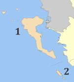
The regional unit Corfu is subdivided into 2 municipalities. These are (number as in the map in the infobox):[1]
Prefecture
As a part of the 2011 Kallikratis government reform, the regional unit Corfu was created out of the former prefecture Corfu (Greek: Νομός Κερκύρας). The prefecture, created in 1864, had the same territory as the present regional unit. At the same time, the municipalities were reorganised, according to the table below.[1]
| New municipality | Old municipalities | Seat |
|---|---|---|
| Corfu | Corfu (city) | Corfu (city) |
| Agios Georgios | ||
| Achilleio | ||
| Ereikoussa | ||
| Esperies | ||
| Thinali | ||
| Kassopaia | ||
| Korissia | ||
| Lefkimmi | ||
| Mathraki | ||
| Meliteieis | ||
| Othonoi | ||
| Palaiokastritsa | ||
| Parelioi | ||
| Faiakes | ||
| Paxoi | Paxoi | Gaios |
Provinces
The provinces were:
Population
| Year | Population |
|---|---|
| 1991 | 105,043 |
| 2001 | 111,975 |
| 2011 | 104,371 |
See also
References
- 1 2 "Kallikratis reform law text" (PDF).
- ↑ "Archived copy" (PDF). Archived from the original (PDF) on 2012-03-25. Retrieved 2012-10-07.
External links
| Regional unit of Corfu |  | |
|---|---|---|
| Regional unit of Cephalonia | ||
| Regional unit of Ithaca | ||
| Regional unit of Lefkada | ||
| Regional unit of Zakynthos | ||
| ||