Pogoni
| Pogoni Πωγώνι | |
|---|---|
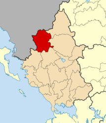 | |
 Pogoni Location within the region | |
| Coordinates: 39°53′N 20°37′E / 39.883°N 20.617°ECoordinates: 39°53′N 20°37′E / 39.883°N 20.617°E | |
| Country | Greece |
| Administrative region | Epirus |
| Regional unit | Ioannina |
| Area | |
| • Municipality | 701.06 km2 (270.68 sq mi) |
| Population (2011)[1] | |
| • Municipality | 8,960 |
| • Municipality density | 13/km2 (33/sq mi) |
| Time zone | UTC+2 (EET) |
| • Summer (DST) | UTC+3 (EEST) |
| Vehicle registration | ΙΝ |
Pogoni (Greek: Πωγώνι) is a municipality in the Ioannina regional unit, Epirus, Greece. The seat of the municipality is the village Kalpaki.[2] The municipality has an area of 701.059 km2.[3] Its population was 8,960 at the 2011 census.[1]
Municipality
The municipality Pogoni was formed at the 2011 local government reform by the merger of the following 6 former municipalities, that became municipal units:[2]
Province
The province of Pogoni (Greek: Επαρχία Πωγωνίου) was one of the provinces of the Ioannina Prefecture. Its territory corresponded with that of the current municipality Pogoni, except the municipal units Ano Kalamas and Kalpaki. Its seat was the village Delvinaki.[4] It was abolished in 2006.
References
- 1 2 "Απογραφή Πληθυσμού - Κατοικιών 2011. ΜΟΝΙΜΟΣ Πληθυσμός" (in Greek). Hellenic Statistical Authority.
- 1 2 Kallikratis law Greece Ministry of Interior (in Greek)
- ↑ "Population & housing census 2001 (incl. area and average elevation)" (PDF) (in Greek). National Statistical Service of Greece.
- ↑ "Detailed census results 1991" (PDF). (39 MB) (in Greek) (in French)
See also
- Pogoni Municipality (Δήμος Πωγωνίου) (in Greek)
| Regional unit of Arta | 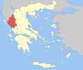 | |
|---|---|---|
| Regional unit of Ioannina | ||
| Regional unit of Preveza | ||
| Regional unit of Thesprotia | ||
| ||
This article is issued from
Wikipedia.
The text is licensed under Creative Commons - Attribution - Sharealike.
Additional terms may apply for the media files.