Karpathos (regional unit)
| Karpathos Περιφερειακή ενότητα Καρπάθου | |
|---|---|
| Regional unit | |
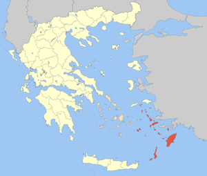
 Municipalities of the Dodecanese | |
 The Dodecanese within Greece | |
| Coordinates: 35°30′N 27°10′E / 35.500°N 27.167°ECoordinates: 35°30′N 27°10′E / 35.500°N 27.167°E | |
| Country | Greece |
| Region | South Aegean |
| Area | |
| • Total | 374.3 km2 (144.5 sq mi) |
| Population (2011) | |
| • Total | 7,310 |
| • Density | 20/km2 (51/sq mi) |
| Time zone | UTC+2 |
| • Summer (DST) | UTC+3 (EEST) |
Karpathos (Greek: Περιφερειακή ενότητα Καρπάθου) is one of the regional units of Greece. It is part of the region of South Aegean. The regional unit covers the islands of Karpathos, Kasos, Saria and several smaller islands in the Aegean Sea.
Administration
As a part of the 2011 Kallikratis government reform, the regional unit Karpathos was created out of part of the former Dodecanese Prefecture. It is subdivided into 2 municipalities. These are (number as in the map in the infobox):[1]
Province
The province of Karpathos (Greek: Επαρχία Καρπάθου) was one of the provinces of the Dodecanese Prefecture. It had the same territory as the present regional unit.[2] It was abolished in 2006.
References
- ↑ "Kallikratis reform law text" (PDF).
- ↑ "Detailed census results 1991" (PDF). Archived from the original (PDF) on 2016-03-03. (39 MB) (in Greek) (in French)
| Regional unit of Andros | 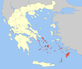 | |
|---|---|---|
| Regional unit of Kalymnos | ||
| Regional unit of Karpathos | ||
| Regional unit of Kea-Kythnos | ||
| Regional unit of Kos | ||
| Regional unit of Milos | ||
| Regional unit of Mykonos | ||
| Regional unit of Naxos | ||
| Regional unit of Paros | ||
| Regional unit of Rhodes | ||
| Regional unit of Syros | ||
| Regional unit of Thira | ||
| Regional unit of Tinos | ||
This article is issued from
Wikipedia.
The text is licensed under Creative Commons - Attribution - Sharealike.
Additional terms may apply for the media files.