Anthousa, Trikala
| Anthousa Ανθούσα | |
|---|---|
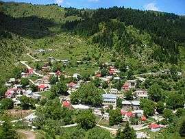 View of Anthousa village | |
 Anthousa | |
| Coordinates: 39°40′N 21°13′E / 39.667°N 21.217°ECoordinates: 39°40′N 21°13′E / 39.667°N 21.217°E | |
| Country | Greece |
| Administrative region | Thessaly |
| Regional unit | Trikala |
| Municipality | Kalampaka |
| Municipal unit | Aspropotamos |
| Community[1] | |
| • Population | 61 (2011) |
| • Area (km2) | 38.723 |
| Time zone | UTC+2 (EET) |
| • Summer (DST) | UTC+3 (EEST) |
| Postal code | 420 36 |
| Area code(s) | +30-2432-xxx-xxx |
| Vehicle registration | ΤΚ |
Anthousa (Greek: Ανθούσα, before 1928: Λεπενίτσα - Lepenitsa[2]) is an Aromanian (Vlach) village in the municipal unit of Aspropotamos in the western part of the Trikala regional unit, Greece. It is located in the southern Pindus mountains, 36 km west of Kalambaka, and 12 km south of Metsovo. The 2011 census recorded 61 residents in Anthousa.[1] The community of Anthousa covers an area of 38.723 km2.[3]
Population
| Year | Population |
|---|---|
| 1981 | 34 |
| 1991 | 37 |
| 2001 | 114 |
| 2011[1] | 61 |
External links
- lipinitsa.gr - Information on Anthoussa in the Trikala prefecture
- Anthoussa on GTP Travel Pages
See also
References
- 1 2 3 "Απογραφή Πληθυσμού - Κατοικιών 2011. ΜΟΝΙΜΟΣ Πληθυσμός" (in Greek). Hellenic Statistical Authority.
- ↑ Name changes of settlements in Greece
- ↑ "Population & housing census 2001 (incl. area and average elevation)" (PDF) (in Greek). National Statistical Service of Greece. Archived from the original (PDF) on 2015-09-21.
This article is issued from
Wikipedia.
The text is licensed under Creative Commons - Attribution - Sharealike.
Additional terms may apply for the media files.