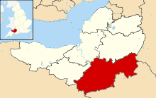
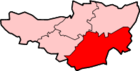
| Image |
Name |
Status |
Population |
Former local authority |
Coordinates |
Refs |
 | Abbas and Templecombe | Civil parish | 1,560 | Wincanton Rural District | 50°59′N 2°25′W / 50.99°N 2.41°W / 50.99; -2.41 (Templecombe) | [3][4] |
 | Alford | Civil parish | 63 | Wincanton Rural District | 51°05′N 2°34′W / 51.08°N 2.57°W / 51.08; -2.57 (Alford, Somerset) | [4] |
 | Aller | Civil parish | 410 | Langport Rural District | 51°03′N 2°51′W / 51.05°N 2.85°W / 51.05; -2.85 (Aller, Somerset) | [3][5] |
 | Ansford | Civil parish | 1,085 | Wincanton Rural District | 51°05′N 2°31′W / 51.09°N 2.51°W / 51.09; -2.51 (Ansford) | [3][4] |
 | Ash | Civil parish | 626 | Yeovil Rural District | 50°59′N 2°45′W / 50.98°N 2.75°W / 50.98; -2.75 (Ash, South Somerset) | [3][6] |
 | Ashill | Civil parish | 529 | Chard Rural District | 50°56′N 2°58′W / 50.94°N 2.96°W / 50.94; -2.96 (Ashill, Somerset) | [3][7] |
 | Babcary | Civil parish | 248 | Langport Rural District | 51°03′N 2°37′W / 51.05°N 2.62°W / 51.05; -2.62 (Babcary) | [3][5] |
 | Barrington | Civil parish | 438 | Langport Rural District | 50°58′N 2°52′W / 50.96°N 2.87°W / 50.96; -2.87 (Barrington, Somerset) | [3][5] |
 | Barton St David | Civil parish | 561 | Langport Rural District | 51°05′N 2°39′W / 51.08°N 2.65°W / 51.08; -2.65 (Barton St David) | [3][5] |
 | Barwick | Civil parish | 1,221 | Yeovil Rural District | 50°55′N 2°37′W / 50.92°N 2.62°W / 50.92; -2.62 (Barwick, Somerset) | [3][6] |
 | Beercrocombe | Civil parish | 134 | Langport Rural District | 50°59′N 2°58′W / 50.98°N 2.97°W / 50.98; -2.97 (Beercrocombe) | [3][5] |
 | Compton Pauncefoot | Civil parish | 130 | Wincanton Rural District | 51°02′N 2°30′W / 51.03°N 2.50°W / 51.03; -2.50 (Compton Pauncefoot) | [4] |
 | Bratton Seymour | Civil parish | 104 | Wincanton Rural District | 51°04′N 2°28′W / 51.07°N 2.47°W / 51.07; -2.47 (Bratton Seymour) | [3][4] |
 | Brewham | Civil parish | 441 | Wincanton Rural District | 51°08′N 2°24′W / 51.13°N 2.40°W / 51.13; -2.40 (Brewham) | [3][4] |
 | Broadway | Civil parish | 740 | Chard Rural District | 50°56′N 2°58′W / 50.93°N 2.97°W / 50.93; -2.97 (Broadway, Somerset) | [3][7] |
 | Bruton | Town | 2,907 | Wincanton Rural District | 51°07′N 2°27′W / 51.11°N 2.45°W / 51.11; -2.45 (Bruton) | [3][4] |
 | Brympton | Civil parish | 7,308 | Yeovil Rural District | 50°56′N 2°41′W / 50.94°N 2.68°W / 50.94; -2.68 (Brympton) | [3][6] |
 | Buckland St Mary | Civil parish | 521 | Chard Rural District | 50°55′N 3°02′W / 50.91°N 3.04°W / 50.91; -3.04 (Buckland St Mary) | [3][7][7] |
 | Castle Cary | Town | 2,276 | Wincanton Rural District | 51°05′N 2°31′W / 51.09°N 2.51°W / 51.09; -2.51 (Castle Cary) | [3][4] |
 | Chaffcombe | Civil parish | 229 | Chard Rural District | 50°53′N 2°55′W / 50.89°N 2.92°W / 50.89; -2.92 (Chaffcombe) | [3][7] |
 | Chard Town | Town | 13,074 | Chard Municipal Borough | 50°52′N 2°58′W / 50.87°N 2.96°W / 50.87; -2.96 (Chard, Somerset) | [3][7] |
 | Charlton Horethorne | Civil parish | 591 | Wincanton Rural District | 51°01′N 2°29′W / 51.01°N 2.48°W / 51.01; -2.48 (Charlton Horethorne) | [3] |
 | Charlton Mackrell | Civil parish | 1,073 | Langport Rural District | 51°03′N 2°41′W / 51.05°N 2.68°W / 51.05; -2.68 (Charlton Mackrell) | [3][5] |
 | Charlton Musgrove | Civil parish | 398 | Wincanton Rural District | 51°05′N 2°23′W / 51.08°N 2.39°W / 51.08; -2.39 (Charlton Musgrove) | [3][4] |
 | Chillington | Civil parish | 164 | Chard Rural District | 50°53′N 2°52′W / 50.89°N 2.87°W / 50.89; -2.87 (Chillington, Somerset) | [3][7] |
 | Chilthorne Domer | Civil parish | 574 | Yeovil Rural District | 50°58′N 2°41′W / 50.97°N 2.68°W / 50.97; -2.68 (Chilthorne Domer) | [3][6] |
 | Chilton Cantelo | Civil parish | 445 | Yeovil Rural District | 51°00′N 2°36′W / 51.00°N 2.60°W / 51.00; -2.60 (Chilton Cantelo) | [3][6] |
 | Chiselborough | Civil parish | 275 | Yeovil Rural District | 50°56′N 2°46′W / 50.93°N 2.76°W / 50.93; -2.76 (Chiselborough) | [3][6] |
 | Closworth | Civil parish | 220 | Yeovil Rural District | 50°53′N 2°37′W / 50.89°N 2.62°W / 50.89; -2.62 (Closworth) | [3][6] |
 | Combe St Nicholas | Civil parish | 1,373 | Chard Rural District | 50°53′N 2°59′W / 50.89°N 2.99°W / 50.89; -2.99 (Combe St Nicholas) | [3][7] |
 | Compton Dundon | Civil parish | 705 | Langport Rural District | 51°05′N 2°44′W / 51.09°N 2.73°W / 51.09; -2.73 (Compton Dundon) | [3][5] |
 | Corton Denham | Civil parish | 189 | Wincanton Rural District | 51°00′N 2°31′W / 51.00°N 2.52°W / 51.00; -2.52 (Corton Denham) | [3][4] |
 | Crewkerne | Town | 7,000 | Crewkerne Urban District | 50°53′N 2°47′W / 50.88°N 2.79°W / 50.88; -2.79 (Crewkerne) | [3][8] |
 | Cricket St Thomas | Civil parish | 50 | Chard Rural District | 50°52′N 2°53′W / 50.87°N 2.89°W / 50.87; -2.89 (Cricket St Thomas) | [7] |
 | Cucklington | Civil parish | 173 | Wincanton Rural District | 51°03′N 2°21′W / 51.05°N 2.35°W / 51.05; -2.35 (Cucklington) | [3][4] |
 | Cudworth | Civil parish | 69 | Chard Rural District | 50°53′N 2°53′W / 50.89°N 2.89°W / 50.89; -2.89 (Cudworth, Somerset) | [7] |
 | Curry Mallet | Civil parish | 306 | Langport Rural District | 50°59′N 2°58′W / 50.99°N 2.96°W / 50.99; -2.96 (Curry Mallet) | [3][5] |
 | Curry Rivel | Civil parish | 2,148 | Langport Rural District | 51°02′N 2°52′W / 51.03°N 2.86°W / 51.03; -2.86 (Curry Rivel) | [3][5] |
 | Dinnington | Civil parish | 65 | Chard Rural District | 50°55′N 2°51′W / 50.91°N 2.85°W / 50.91; -2.85 (Dinnington, Somerse) | [7] |
 | Donyatt | Civil parish | 347 | Chard Rural District | 50°56′N 2°57′W / 50.93°N 2.95°W / 50.93; -2.95 (Donyatt) | [3][7] |
 | Dowlish Wake | Civil parish | 277 | Chard Rural District | 50°55′N 2°53′W / 50.91°N 2.89°W / 50.91; -2.89 (Dowlish Wake) | [3][7] |
 | Drayton | Civil parish | 379 | Langport Rural District | 51°01′08″N 2°51′00″W / 51.019°N 2.85°W / 51.019; -2.85 (Drayton, Somerset) | [3][5] |
 | East Chinnock | Civil parish | 479 | Yeovil Rural District | 50°55′N 2°43′W / 50.92°N 2.72°W / 50.92; -2.72 (The Chinnocks) | [3][6] |
 | East Coker | Civil parish | 1,667 | Yeovil Rural District | 50°55′N 2°39′W / 50.91°N 2.65°W / 50.91; -2.65 (East Coker) | [3][6] |
 | Fivehead | Civil parish | 609 | Langport Rural District | 50°59′N 2°55′W / 50.99°N 2.92°W / 50.99; -2.92 (Fivehead) | [3][5] |
 | Hambridge and Westport | Civil parish | 514 | Langport Rural District | 50°59′N 2°52′W / 50.99°N 2.86°W / 50.99; -2.86 (Hambridge and Westport) | [3][5] |
 | Hardington Mandeville | Civil parish | 585 | Yeovil Rural District | 50°54′N 2°41′W / 50.90°N 2.69°W / 50.90; -2.69 (Hardington Mandeville) | [3][6] |
 | Haselbury Plucknett | Civil parish | 744 | Yeovil Rural District | 50°53′N 2°45′W / 50.89°N 2.75°W / 50.89; -2.75 (Haselbury Plucknett) | [3][6] |
 | Henstridge | Civil parish | 1,814 | Wincanton Rural District | 50°58′N 2°23′W / 50.97°N 2.39°W / 50.97; -2.39 (Henstridge) | [3] |
 | High Ham | Civil parish | 909 | Langport Rural District | 51°05′N 2°49′W / 51.08°N 2.82°W / 51.08; -2.82 (High Ham) | [3][5] |
 | Hinton St George | Civil parish | 442 | Chard Rural District | 50°55′N 2°49′W / 50.91°N 2.82°W / 50.91; -2.82 (Hinton St George) | [3][7] |
 | Holton | Civil parish | 238 | Wincanton Rural District | 51°02′N 2°27′W / 51.04°N 2.45°W / 51.04; -2.45 (Holton, Somerset) | [3][4] |
 | Horsington | Civil parish | 571 | Wincanton Rural District | 51°01′N 2°26′W / 51.01°N 2.43°W / 51.01; -2.43 (Horsington, Somerset) | [3][4] |
 | Horton | Civil parish | 812 | Chard Rural District | 50°56′N 2°58′W / 50.93°N 2.97°W / 50.93; -2.97 (Horton, Somerset) | [3][7] |
 | Huish Episcopi | Civil parish | 2,095 | Langport Rural District | 51°02′N 2°49′W / 51.04°N 2.81°W / 51.04; -2.81 (Huish Episcopi) | [3][5] |
 | Ilchester | Civil parish | 2,153 | Yeovil Rural District | 51°00′N 2°41′W / 51.00°N 2.68°W / 51.00; -2.68 (Ilchester) | [3][6] |
 | Ilminster | Town | 5,808 | Chard Rural District
Ilminster Urban District | 50°56′N 2°55′W / 50.93°N 2.91°W / 50.93; -2.91 (Ilminster) | [3][7] |
 | Ilton | Civil parish | 854 | Chard Rural District | 50°57′N 2°55′W / 50.95°N 2.92°W / 50.95; -2.92 (Ilton) | [3][7] |
 | Isle Abbots | Civil parish | 205 | Langport Rural District | 50°59′N 2°55′W / 50.98°N 2.92°W / 50.98; -2.92 (Isle Abbots) | [3][5] |
 | Isle Brewers | Civil parish | 150 | Langport Rural District | 50°59′N 2°54′W / 50.99°N 2.90°W / 50.99; -2.90 (Isle Brewers) | [3] |
 | Keinton Mandeville | Civil parish | 1,068 | Langport Rural District | 51°04′N 2°39′W / 51.07°N 2.65°W / 51.07; -2.65 (Keinton Mandeville) | [3][5] |
 | Kingsbury Episcopi | Civil parish | 1,307 | Langport Rural District | 50°59′N 2°49′W / 50.99°N 2.81°W / 50.99; -2.81 (Kingsbury Episcopi) | [3][5] |
 | Kingsdon | Civil parish | 303 | Langport Rural District | 51°02′N 2°41′W / 51.04°N 2.69°W / 51.04; -2.69 (Kingsdon, Somerset) | [3][5] |
 | Kingstone | Civil parish | 83 | Chard Rural District | 50°55′N 2°53′W / 50.92°N 2.89°W / 50.92; -2.89 (Kingstone, Somerset) | [7] |
 | Kingweston | Civil parish | 128 | Langport Rural District | 51°05′N 2°41′W / 51.08°N 2.68°W / 51.08; -2.68 (Kingweston) | [5] |
 | Knowle St Giles | Civil parish | 244 | Chard Rural District | 50°54′N 2°56′W / 50.90°N 2.93°W / 50.90; -2.93 (Knowle St Giles) | [3][7] |
 | Langport | Town | 1,081 | Langport Rural District | 51°02′N 2°50′W / 51.04°N 2.83°W / 51.04; -2.83 (Langport) | [3][5] |
 | Limington | Civil parish | 199 | Yeovil Rural District | 50°59′N 2°39′W / 50.99°N 2.65°W / 50.99; -2.65 (Limington) | [6] |
 | Long Load | Civil parish | 332 | Yeovil Rural District | 51°01′N 2°46′W / 51.01°N 2.76°W / 51.01; -2.76 (Long Load) | [3][6] |
| Long Sutton | Civil parish | 833 | Langport Rural District | | [3][5] |
 | Lopen | Civil parish | 260 | Chard Rural District | 50°56′N 2°49′W / 50.93°N 2.82°W / 50.93; -2.82 (Lopen) | [3][7] |
 | Lovington | Civil parish | 141 | Wincanton Rural District | 51°04′N 2°35′W / 51.07°N 2.58°W / 51.07; -2.58 (Lovington, Somerset) | [3][4] |
 | Maperton | Civil parish | 140 | Wincanton Rural District | 51°02′N 2°28′W / 51.04°N 2.46°W / 51.04; -2.46 (Maperton) | [3][4] |
 | Marston Magna | Civil parish | 523 | Yeovil Rural District | 51°00′N 2°35′W / 51.00°N 2.58°W / 51.00; -2.58 (Marston Magna) | [3][6] |
 | Martock | Civil parish | 4,766 | Yeovil Rural District | 50°58′N 2°46′W / 50.97°N 2.77°W / 50.97; -2.77 (Martock) | [3][6] |
 | Merriott | Civil parish | 1,979 | Chard Rural District | 50°55′N 2°47′W / 50.91°N 2.79°W / 50.91; -2.79 (Merriott) | [3][7] |
 | Milborne Port | Civil parish | 2,802 | Wincanton Rural District | 50°58′N 2°28′W / 50.97°N 2.46°W / 50.97; -2.46 (Milborne Port) | [3][4] |
 | Misterton | Civil parish | 826 | Chard Rural District | 50°52′N 2°47′W / 50.87°N 2.78°W / 50.87; -2.78 (Misterton, Somerset) | [3][7] |
 | Montacute | Civil parish | 831 | Yeovil Rural District | 50°57′N 2°43′W / 50.95°N 2.72°W / 50.95; -2.72 (Montacute) | [3][6] |
 | Muchelney | Civil parish | 195 | Langport Rural District | 51°01′16″N 2°49′12″W / 51.021°N 2.82°W / 51.021; -2.82 (Muchelney) | [3][5] |
 | Mudford | Civil parish | 696 | Yeovil Rural District | 50°58′N 2°37′W / 50.97°N 2.61°W / 50.97; -2.61 (Mudford) | [3][6] |
 | North Barrow | Civil parish | 233 | Wincanton Rural District | 51°04′N 2°34′W / 51.06°N 2.57°W / 51.06; -2.57 (North Barrow) | [3][4] |
 | North Cadbury | Civil parish | 950 | Wincanton Rural District | 51°03′N 2°31′W / 51.05°N 2.52°W / 51.05; -2.52 (North Cadbury) | [3][4] |
 | North Cheriton | Civil parish | 208 | Wincanton Rural District | 51°02′N 2°26′W / 51.03°N 2.44°W / 51.03; -2.44 (North Cheriton) | [3][4] |
 | North Perrott | Civil parish | 246 | Yeovil Rural District | 50°53′N 2°45′W / 50.88°N 2.75°W / 50.88; -2.75 (North Perrott) | [3][6] |
 | Norton sub Hamdon | Civil parish | 743 | Yeovil Rural District | 50°56′N 2°46′W / 50.94°N 2.76°W / 50.94; -2.76 (Norton Sub Hamdon) | [3][6] |
 | Odcombe | Civil parish | 759 | Yeovil Rural District | 50°56′N 2°42′W / 50.94°N 2.70°W / 50.94; -2.70 (Odcombe) | [3][6] |
 | Penselwood | Civil parish | 273 | Wincanton Rural District | 51°05′N 2°21′W / 51.08°N 2.35°W / 51.08; -2.35 (Penselwood) | [3][4] |
 | Pitcombe | Civil parish | 532 | Wincanton Rural District | 51°06′N 2°28′W / 51.10°N 2.47°W / 51.10; -2.47 (Pitcombe) | [3][4] |
 | Pitney | Civil parish | 374 | Langport Rural District | 51°03′N 2°47′W / 51.05°N 2.79°W / 51.05; -2.79 (Pitney) | [3][5] |
 | Puckington | Civil parish | 117 | Langport Rural District | 50°58′N 2°53′W / 50.96°N 2.89°W / 50.96; -2.89 (Puckington) | [3][5] |
 | Queen Camel | Civil parish | 908 | Wincanton Rural District | 51°01′N 2°35′W / 51.02°N 2.58°W / 51.02; -2.58 (Queen Camel) | [3][4] |
 | Rimpton | Civil parish | 235 | Yeovil Rural District | 50°59′N 2°34′W / 50.99°N 2.56°W / 50.99; -2.56 (Rimpton) | [3][6] |
 | Seavington St Mary | Civil parish | 384 | Chard Rural District | 50°56′N 2°52′W / 50.93°N 2.86°W / 50.93; -2.86 (Seavington St Mary) | [3][7] |
 | Seavington St Michael | Civil parish | 127 | Chard Rural District | 50°56′N 2°50′W / 50.93°N 2.84°W / 50.93; -2.84 (Seavington St Michael) | [3][7] |
 | Shepton Beauchamp | Civil parish | 728 | Chard Rural District | 50°57′N 2°51′W / 50.95°N 2.85°W / 50.95; -2.85 (Shepton Beauchamp) | [3][7] |
 | Shepton Montague | Civil parish | 208 | Wincanton Rural District | 51°05′N 2°28′W / 51.08°N 2.47°W / 51.08; -2.47 (Shepton Montague) | [3][4] |
 | Somerton | Town | 4,697 | Langport Rural District | 51°03′N 2°44′W / 51.05°N 2.74°W / 51.05; -2.74 (Somerton) | [3][5] |
 | South Barrow | Civil parish | 162 | Wincanton Rural District | 51°03′N 2°34′W / 51.05°N 2.56°W / 51.05; -2.56 (South Barrow) | [3][4] |
 | South Cadbury | Civil parish | 284 | Wincanton Rural District | 51°02′N 2°31′W / 51.03°N 2.52°W / 51.03; -2.52 (South Cadbury) | [3][4] |
 | South Petherton | Civil parish | 3,367 | Yeovil Rural District | 50°57′N 2°49′W / 50.95°N 2.81°W / 50.95; -2.81 (South Petherton) | [3][6] |
 | Sparkford | Civil parish | 617 | Wincanton Rural District | 51°02′N 2°34′W / 51.04°N 2.57°W / 51.04; -2.57 (Sparkford) | [3][4] |
 | Stocklinch | Civil parish | 154 | Chard Rural District | 50°57′N 2°53′W / 50.95°N 2.88°W / 50.95; -2.88 (Stocklinch) | [3][7] |
 | Stoke sub Hamdon | Civil parish | 1,068 | Yeovil Rural District | 50°57′N 2°45′W / 50.95°N 2.75°W / 50.95; -2.75 (Stoke-sub-Hamdon) | [3][6] |
 | Stoke Trister | Civil parish | 313 | Wincanton Rural District | 51°04′N 2°23′W / 51.06°N 2.38°W / 51.06; -2.38 (Stoke Trister) | [3][4] |
 | Tatworth and Forton | Civil parish | 2,660 | Chard Rural District | 50°51′N 2°58′W / 50.85°N 2.96°W / 50.85; -2.96 (Tatworth) | [3][7] |
 | Tintinhull | Civil parish | 902 | Yeovil Rural District | 50°58′N 2°43′W / 50.97°N 2.71°W / 50.97; -2.71 (Tintinhull) | [3][6] |
 | Wambrook | Civil parish | 184 | Chard Rural District | 50°52′N 3°00′W / 50.86°N 3.00°W / 50.86; -3.00 (Wambrook) | [3][7] |
 | Wayford | Civil parish | 114 | Chard Rural District | 50°51′N 2°51′W / 50.85°N 2.85°W / 50.85; -2.85 (Wayford) | [7] |
 | West Camel | Civil parish | 459 | Yeovil Rural District | 51°01′N 2°36′W / 51.02°N 2.60°W / 51.02; -2.60 (West Camel) | [3][6] |
 | West and Middle Chinnock | Civil parish | 592 | Yeovil Rural District | 50°55′N 2°46′W / 50.92°N 2.76°W / 50.92; -2.76 (West Chinnock) | [3][6] |
 | West Coker | Civil parish | 2,018 | Yeovil Rural District | 50°55′N 2°41′W / 50.92°N 2.69°W / 50.92; -2.69 (West Coker) | [3][6] |
| West Crewkerne | Civil parish | 631 | Chard Rural District | 50°53′N 2°47′W / 50.88°N 2.79°W / 50.88; -2.79 (Crewkerne) | [3][7] |
 | Whitelackington | Civil parish | 209 | Chard Rural District | 50°56′N 2°53′W / 50.94°N 2.88°W / 50.94; -2.88 (Whitelackington) | [3][7] |
 | Whitestaunton | Civil parish | 256 | Chard Rural District | 50°53′N 3°01′W / 50.89°N 3.02°W / 50.89; -3.02 (Whitestaunton) | [3][7] |
 | Wincanton | Town | 5,272 | Wincanton Rural District | 51°04′N 2°25′W / 51.06°N 2.41°W / 51.06; -2.41 (Wincanton) | [3][4] |
 | Winsham | Civil parish | 748 | Chard Rural District | 50°51′N 2°53′W / 50.85°N 2.89°W / 50.85; -2.89 (Winsham) | [3][7] |
 | Yarlington | Civil parish | 123 | Wincanton Rural District | 51°04′N 2°29′W / 51.06°N 2.49°W / 51.06; -2.49 (Yarlington) | [3][4] |
 | Yeovil | Town | 30,378 | Yeovil Municipal Borough | 50°57′N 2°38′W / 50.95°N 2.64°W / 50.95; -2.64 (Yeovil) | [3][9] |
 | Yeovil Without | Civil parish | 6,834 | Yeovil Rural District | 50°58′N 2°39′W / 50.96°N 2.65°W / 50.96; -2.65 (Yeovil Without) | [3][6] |
 | Yeovilton | Civil parish | 1,226 | Yeovil Rural District | 51°00′N 2°39′W / 51.00°N 2.65°W / 51.00; -2.65 (Yeovilton) | [3][6] |