River Barle
| River Barle | |
| River | |
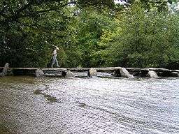 Tarr Steps viewed downstream | |
| Country | England |
|---|---|
| Counties | Devon, Somerset |
| Tributaries | |
| - left | Little River |
| - right | Sherdon Water |
| Cities | Withypool, Simonsbath |
| Landmark | Tarr Steps |
| Source | |
| - location | Near Simonsbath, Exmoor, Somerset |
| - elevation | 400 m (1,312 ft) |
| - coordinates | 51°08′30″N 3°48′38″W / 51.14167°N 3.81056°W |
| Mouth | River Exe |
| - location | Exebridge, Devon |
| - coordinates | 51°00′37″N 3°31′55″W / 51.01028°N 3.53194°WCoordinates: 51°00′37″N 3°31′55″W / 51.01028°N 3.53194°W |
| Length | 39.6[1] km (25 mi) |
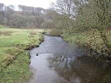
The River Barle runs from the Chains on northern Exmoor, in Somerset, England to join the River Exe at Exebridge, Devon. The river and the Barle Valley are both designated as biological Site of Special Scientific Interest.
On the Chains above Simonsbath is a 3-acre (1.2-hectare) reservoir known as Pinkery Pond. It was formed by damming the River Barle, in the 19th century by John Knight and his son, and was originally intended to be 7 acres (2.8 ha). The purpose is unknown but close to the pond is the remains of a small canal.[2] Wheal Eliza Mine was an unsuccessful copper and iron mine on the river near Simonsbath.
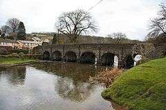
The river passes under a late medieval six-arch stone Landacre Bridge in Withypool,[3] and the Tarr Steps a prehistoric clapper bridge possibly dating from 1000 BC. The stone slabs weigh up to 5 tons apiece. According to local legend, they were placed by the devil to win a bet. The bridge is 180 feet (55 m) long and has 17 spans.[4] It has been designated by English Heritage as a grade I listed building.[5] In Dulverton the river is crossed by the Barle Bridge.
Ecology
The river flows through the Somerset Wildlife Trust's Mounsey Wood Nature Reserve and Knaplock and North Barton SSSI, first notified in 1954, which are within Exmoor National Park. This is notable for the presence of rare plant and bird life and including Kingfisher habitats and one of the only sites of great burnet (Sanguisorba officinalis) on Exmoor. The river itself has been recorded as a habitat for otters.[6]
Recreation
Angling
Walking
For much of its route, the river's banks are the path of the Two Moors Way footpath.[8]
Kayaking and canoeing
The upper reaches of the Barle produced favourable rapids which appeal to whitewater kayakers. The rapids are Graded at 2 (3-) which beginner to intermediate kayakers and canoeists paddle.[9][10]
See also
| Wikimedia Commons has media related to River Barle. |
References
- ↑ Lower Barle Middle Barle Upper Barle - Catchment Data Explorer
- ↑ Warren, Derrick (2005). Curious Somerset. Stroud: Sutton Publishing. pp. 107–108. ISBN 978-0-7509-4057-3.
- ↑ "Landacre Bridge". Images of England. English Heritage. Retrieved 2008-10-18.
- ↑ Leete-Hodge, Lornie (1985). Curiosities of Somerset. Bodmin: Bossiney Books. pp. 63–64. ISBN 0-906456-98-3.
- ↑ "Tarr Steps". Images of England. Archived from the original on 2008-03-06. Retrieved 2007-05-09.
- ↑ "Barle Valley" (PDF). Natural England. Retrieved 2018-06-28.
- ↑ "River Barle". Everything Exmoor. Retrieved 2008-10-18.
- ↑ "Walk 1860 - The River Barle and Withypool from Tarr Steps". Walking Britain. Retrieved 2008-10-18.
- ↑ "Guide to the River Barle". UK Rivers Guidebook. Retrieved 2010-10-05.
- ↑ "River Barle". British Canoe Union South West. Archived from the original on 2008-10-24. Retrieved 2008-10-18.