Silver Line (MBTA)
|
| |
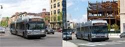 MBTA Neoplan AN460LF CNG (left) and AN460LF dual mode trackless trolley (right) on Silver Line duty. | |
| Parent | Massachusetts Bay Transportation Authority |
|---|---|
| Founded |
2002 (Washington Street) 2004 (Airport/Waterfront) |
| Headquarters | 10 Park Plaza, Boston, MA 02116 |
| Locale | Boston, Massachusetts |
| Service type | Bus rapid transit |
| Routes | 5 |
| Stations |
14 (Washington Street) 20 (Waterfront) |
| Fleet |
24 (Washington Street) 32 (Airport/Waterfront) |
| Daily ridership | 33,386 (2014)[1] |
| Operator | MBTA |
| Website | MBTA Silver Line |
Silver Line route diagram | |||||||||||||||||||||||||||||||||||||||||||||||||||||||||||||||||||||||||||||||||||||||||||||||||||||||||||||||||||||||||||||||||||||||||||||||||||||||||||||||||||||||||||||||||||||||||||||||||||||||||||||||||||||||||||||||||||||||||||||||||||||||||||||||||||||||||||||||||||||||||||||||||||||||||||||||
|---|---|---|---|---|---|---|---|---|---|---|---|---|---|---|---|---|---|---|---|---|---|---|---|---|---|---|---|---|---|---|---|---|---|---|---|---|---|---|---|---|---|---|---|---|---|---|---|---|---|---|---|---|---|---|---|---|---|---|---|---|---|---|---|---|---|---|---|---|---|---|---|---|---|---|---|---|---|---|---|---|---|---|---|---|---|---|---|---|---|---|---|---|---|---|---|---|---|---|---|---|---|---|---|---|---|---|---|---|---|---|---|---|---|---|---|---|---|---|---|---|---|---|---|---|---|---|---|---|---|---|---|---|---|---|---|---|---|---|---|---|---|---|---|---|---|---|---|---|---|---|---|---|---|---|---|---|---|---|---|---|---|---|---|---|---|---|---|---|---|---|---|---|---|---|---|---|---|---|---|---|---|---|---|---|---|---|---|---|---|---|---|---|---|---|---|---|---|---|---|---|---|---|---|---|---|---|---|---|---|---|---|---|---|---|---|---|---|---|---|---|---|---|---|---|---|---|---|---|---|---|---|---|---|---|---|---|---|---|---|---|---|---|---|---|---|---|---|---|---|---|---|---|---|---|---|---|---|---|---|---|---|---|---|---|---|---|---|---|---|---|---|---|---|---|---|---|---|---|---|---|---|---|---|---|---|---|---|---|---|---|---|---|---|---|---|---|---|---|---|---|---|---|---|
| |||||||||||||||||||||||||||||||||||||||||||||||||||||||||||||||||||||||||||||||||||||||||||||||||||||||||||||||||||||||||||||||||||||||||||||||||||||||||||||||||||||||||||||||||||||||||||||||||||||||||||||||||||||||||||||||||||||||||||||||||||||||||||||||||||||||||||||||||||||||||||||||||||||||||||||||
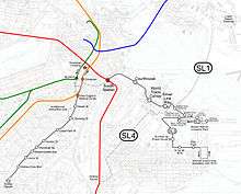
The Silver Line is the bus rapid transit (BRT) system of the Massachusetts Bay Transportation Authority (MBTA). It currently operates five routes in two sections that were built in separate phases.
The first section has two routes from Dudley Square in Roxbury, mostly via Washington Street, to Boston's Downtown Crossing (SL5) and South Station (SL4), using articulated buses operating in reserved lanes. The second section runs from South Station Under to Logan Airport in East Boston (SL1), South Boston (SL2), and to Chelsea via the Chelsea Street Bridge (SL3).[2] The second section runs dual-mode buses, partly in a dedicated bus tunnel and partly on shared roadway, including surface streets, the Ted Williams Tunnel, and airport roads. Riders can transfer between the sections and to other lines at South Station; transfers there between SL1, SL2, SL3, and the Red Line—but not SL4—are within fare control. A transfer between these lines and the SL4 can be made at street level just outside South Station.
Speed and schedule performance have disappointed some transit advocates and the Silver Line routes fall short of the minimum BRT Standard promulgated by the Institute for Transportation and Development Policy (ITDP). Some sections have an exclusive right-of-way, but other sections are often delayed by street running in congested mixed traffic.
Service routes
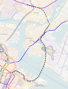
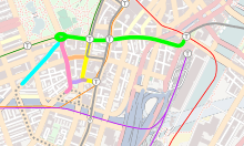
Waterfront: SL1, SL2, SL3
_1297.jpg)
Three Silver Line services operate in a dedicated tunnel from South Station to Boston World Trade Center, then in a reserved surface right-of-way for another two blocks farther east to Silver Line Way station and beyond there in mixed traffic:
- SL1 Logan Airport – South Station
- SL2 Design Center – South Station
- SL3 Chelsea – South Station
During rush hours, additional short turns are run between South Station and Silver Line Way to increase frequency on the busiest section of the line.
SL1 buses operate in a loop at Logan Airport and only serve the terminal buildings (A, B1, B2, C, E), stopping at the arrivals level. SL3 buses bypass the terminals, but service the Blue Line's Airport station. Both the SL1 and SL3's stops allow passengers to transfer to Massport's free shuttle buses that connect the stations with each other and with other airport destinations, including hotels, the rental car center, and the water taxi dock. A system of moving walkways connects Terminals A and E, the Hilton Hotel, and the central parking area.
Fares
Passengers traveling on SL1, SL2, and SL3 pay the standard MBTA subway fare: $2.25 when using a CharlieCard, $2.75 when using CharlieTickets or cash. Ticket vending machines that accept cash and credit cards are installed in the Logan Airport terminals and World Trade Center, Courthouse and South Stations. A faregate-free and cost-free transfer to and from the Red Line is available at South Station for all Waterfront Silver Line riders, but only CharlieCard users get free transfers to other bus lines and reduced fare on Express Bus. CharlieCard and CharlieTicket users but not cash users also get a free transfer to SL4 service at its terminus outside South Station, at street level.
Passengers boarding SL1 at Logan Airport do not have to pay any fare as part of a program to speed up service by allowing passengers to board using all three sets of doors.[1] The fare-free boarding began as a pilot program on June 6, 2012;[3][4] Silver Line ridership both to and from the airport has increased and Blue Line ridership held steady, indicating that the program was increasing transit usage at the airport.[5] Massport reimburses the MBTA for all lost fare revenue, subject to FAA approval, as airport revenue cannot normally be used for outside projects.[1]
Rolling stock
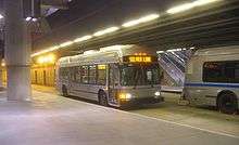
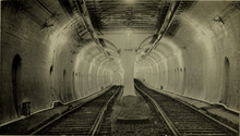
From South Station to Silver Line Way the Neoplan USA AN460LF dual-mode 60 foot articulated buses on these services operate as trolleybuses, powered by overhead electrical wire, to avoid generating internal combustion fumes in the tunnel, and continue on thereafter on diesel power, which is converted to electrical power to run the same electric motors used when running on overhead power. These buses provide higher capacity than standard 40-foot buses. Both the rear and center wheels are powered by electric motors, which permits these buses to continue operation even through snow. These buses are wheelchair ramp–equipped, using kneeling bus technology and a flip-out ramp. (See MBTA accessibility for more information.)
On June 18, 2014, the MBTA approved a $18.5 million contract with Maine Military Authority to overhaul the 32 dual-mode buses. After several buses were delivered, the contract was renegotiated in 2016. The overhauls were completed in August 2018.[6].
Five additional all-electric battery-powered buses will arrive in 2019 for Silver Line use.[6] An option order on a separate bus order with New Flyer allowed the MBTA to order a single diesel-electric hybrid bus with the ability to travel solely on battery power for several miles. If that test bus is deemed successful, the MBTA can purchase 45 additional such buses to fully replace the dual-mode fleet. This bus has arrived for testing.[6]
Station listing
.jpg)
| Neighborhood | Station [7] | Routes | Opened | Transfers and notes |
|---|---|---|---|---|
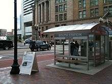
| Downtown Boston | South Station | SL1, SL2,
SL3 |
December 17, 2004 | Red Line, Silver Line SL4, MBTA Commuter Rail, Amtrak, local and intercity buses |
| South Boston | Courthouse | SL1, SL2,
SL3 |
December 17, 2004 | |
| South Boston | World Trade Center | SL1, SL2,
SL3 |
December 17, 2004 | seasonal ferry to Provincetown |
| South Boston | Silver Line Way | SL1, SL2,
SL3 |
December 17, 2004 | Changeover between diesel and overhead electric power takes place here |
| East Boston | Logan Airport Terminal A | SL1 | June 1, 2005 | Massport shuttle buses |
| East Boston | Logan Airport Terminal B west | SL1 | June 1, 2005 | Massport shuttle buses |
| East Boston | Logan Airport Terminal B east | SL1 | June 1, 2005 | Massport shuttle buses |
| East Boston | Logan Airport Terminal C | SL1 | June 1, 2005 | Massport shuttle buses |
| East Boston | Logan Airport Terminal E | SL1 | June 1, 2005 | Massport shuttle buses |
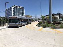
| East Boston | Airport Station | SL3 | April 21, 2018 | Blue Line subway, Massport shuttle buses to Logan International Airport |
| Chelsea | Eastern Avenue | SL3 | April 21, 2018 | 112 bus line, Massport employee shuttle buses |
| Chelsea | Box District | SL3 | April 21, 2018 | 116, 117 bus line |
| Chelsea | Bellingham Square | SL3 | April 21, 2018 | 111, 112, 114, bus lines, Commuter Rail (Newburyport/Rockport Line) |
| Chelsea | Chelsea | SL3 | April 21, 2018 | 112, 114 bus lines, Commuter Rail (Newburyport/Rockport Line, beginning Summer 2019) |
| South Boston | Congress at World Trade Center | SL1, SL3 | June 1, 2005 | Dropoff-only stop on Congress Street served by inbound SL1 and SL3 buses only |
| South Boston | Northern Avenue & Harbor Street | SL2 | December 31, 2004 | Bus Line 4 |
| South Boston | Northern Avenue & Tide Street | SL2 | December 31, 2004 | Bus Line 4 |
| South Boston | 23 Dry Dock Avenue | SL2 | December 31, 2004 | Stop called 21 Drydock Avenue until 2016 |
| South Boston | 27 Dry Dock Avenue | SL2 | December 31, 2004 | Stop called 25 Drydock Avenue until 2016 |
| South Boston | 88 Black Falcon Avenue | SL2 | December 31, 2004 | Cruise ship terminal |
| South Boston | Design Center | SL2 | December 31, 2004 | Bus Line 4 |
Washington Street: SL4 and SL5
Two Silver Line services run between Dudley Square in Roxbury and downtown Boston along Washington Street in reserved bus lanes:
- SL4 Dudley Square – South Station
- SL5 Dudley Square – Downtown Crossing
These two services share most of their route from Dudley Square to Chinatown; SL5 continues northward to Downtown Crossing and Boylston stations, whereas SL4 heads east on Essex Street to South Station.[8] Passengers can transfer to SL1, SL2, and SL3 buses at South Station; however, SL4 buses stop at a surface bus stop across the street from the station complex, whereas SL1, SL2, and SL3 buses stop at an underground stop within the station, so there is no direct transfer or capability for through service.
Fares
Passengers traveling on SL4 and SL5 pay the standard MBTA bus fare: $1.70 when using a CharlieCard, $2.00 when using a CharlieTicket or cash. At select stations, passengers can transfer from the Silver Line to the subway (Red, Green and Orange Lines) for an additional 50 cents when using a CharlieCard. At these same stations, passengers may transfer from the subway to the Silver Line for free.[9]
Rolling stock
Diesel hybrid powered 60-foot articulated buses are used on the SL4 and SL5 services for greater capacity than that provided by standard buses.[6] Standard (40-foot, non-articulated) buses are used during snowstorms. As with SL1, SL2, and SL3, these buses are wheelchair ramp-equipped, using kneeling bus technology and a flip-out ramp. (See MBTA accessibility for more information.)
Station listing
All stops opened for Silver line service on July 20, 2002 unless otherwise noted.[10]
| Neighborhood | Station | Routes | Connections |
|---|---|---|---|
| Roxbury | Dudley Square | SL4 and SL5 | 1, 8, 14, 15, 19, 23, 25, 28, 41, 42, 44, 45, 47, 66, 170, and 171 bus lines |
| Melnea Cass Boulevard | SL4 and SL5 | ||
| South End | Lenox Street | SL4 and SL5 | |
| Massachusetts Avenue | SL4 and SL5 | 1 and CT1 (Not the same as Massachusetts Avenue station on Orange Line, 1/2 mile northwest) | |
| Worcester Square | SL4 and SL5 | Discontinued when the 49 was replaced by the Silver Line; restored in late 2002[10] | |
| Newton Street | SL4 and SL5 | ||
| Union Park Street | SL4 and SL5 | ||
| East Berkeley Street | SL4 and SL5 | 9, 11 (inbound buses only) | |
| Herald Street | SL4 and SL5 | 9 (outbound buses only) | |
| Chinatown | Tufts Medical Center | SL4 and SL5 | 11, 43 and Orange Line |
| Chinatown | SL4 and SL5 | 11 and Orange Line (inbound buses only) | |
| Downtown Boston | Boylston | SL5 | 43, 55 and Green Line (outbound buses only) |
| Downtown Crossing | SL5 | Orange Line and Red Line at Downtown Crossing; Green Line at Park Street | |
| South Station | SL4 | SL1, SL2, SL3, Red Line, MBTA commuter rail, Amtrak, local and intercity buses. Silver Line stop opened on October 13, 2009[10] |
History
Subway and streetcar proposals
In 1948 a state study, Surging Cities, made proposals for transportation in Boston. It had four proposals and the second part proposed that the Washington Street Elevated (operational, 1901–1987) elevated train line be replaced by a subway line for the length of Washington Street through Dudley Square to the line's terminus at Forest Hills. While $19,000,000 was initially budgeted, the subway part of the four proposals was shelved.[11][12] Prior to the Elevated's removal, area residents petitioned to retain the line until a promised light-rail vehicle line could be established.[12] Light-rail proposals generally envisioned extending the Green Line by reopening the southern part of the Tremont Street Tunnel (operational from 1897 to 1961) and extending surface light-rail trackage along Washington Street to Dudley Square.[13] After the elevated line was scrapped in 1987, the MBTA withdrew its streetcar promise.[12]
Silver Line development
The collection of services under the Silver Line umbrella have varying origins. The first section opened, known as Silver Line Phase I, was the line along Washington Street now referred to as SL5; it is the product of community demands for restoration of local service after the Washington Street Elevated portion of the Orange Line was demolished in 1987.[14] Proposals to build a new subway line under Washington Street or a new trolley line along Washington Street were deemed impractical, so the Orange Line was re-routed about 1/2 mile west onto the Southwest Corridor right-of-way, leaving many local residents without a rapid-transit option. BRT was chosen to provide this service. The line started running July 20, 2002, replacing service provided by the 49 bus (which had existed as a feeder route before 1987).
The tunneled section extending east of South Station, known as Silver Line Phase II, was constructed in conjunction with Boston's Big Dig and was originally referred to as the South Boston Piers Transitway. Tunnel sections were fabricated in a nearby, World War II–era dry dock and floated into place. Phase II opened on Friday, December 17, 2004, with the first route (Silver Line Waterfront) running only to Silver Line Way, temporarily using new electric trolley buses borrowed from the trackless trolley routes that have their hub in Cambridge, as not enough dual-mode buses were available initially.
When dual-mode buses were placed in service on December 31, 2004, two routes, dubbed SL2 and SL3, began service. As still not enough dual-mode buses were available, some rush-hour service was provided by CNG buses, with transfers at Silver Line Way. Through service was suspended after January 5, 2005, and was not brought back until March 5, with all buses dual-mode starting on March 14. Beginning on March 26, late night and weekend trips ran combined, running both around the BMIP loop and to City Point. The SL3 service ran to City Point via the Boston Marine Industrial Park;[15] however, its ridership was low due to competition from the parallel 7 bus. The 7 is frequent (with 6-minute headways during rush hour), cost less and runs to Downtown Crossing rather than just to South Station. SL3 service was canceled in March 2009.[10]
SL1 service to Logan Airport began on an interim basis on January 2, 2005. CNG buses ran on a Sunday-only (4 pm–10 pm only) shuttle route between Silver Line Way and the airport terminals. The agreement with the Massachusetts Department of Environmental Protection had called for airport service by January, but the MBTA did not yet have enough dual-mode buses for full service.[16] Full-time SL1 service began on June 1, 2005.[10]
An SL4 route from South Station to Andrew station via the Boston Convention and Exhibition Center and D Street was planned to open in 2005, but was not implemented.[17] The SL4 designation was used for another route in 2009.
For nearly five years after the opening of Silver Line Phase II, the two segments of the Silver Line were disconnected from one another. The MBTA wanted to connect the two via an underground tunnel, however the construction of this section, dubbed Silver Line Phase III, is no longer included in the region's long term plan due to funding concerns. A partial solution that did not require a new tunnel opened on October 13, 2009, after fast-track construction using federal stimulus money. The new route, SL4, covers much of the same ground as the proposed Phase III in a dedicated bus lane on the surface that terminates across Atlantic Avenue from South Station, allowing a somewhat circuitous pedestrian transfer between Phase I and Phase II. When SL4 began operation, the existing Silver Line Washington Street service was rebranded SL5.
Extension to Chelsea
In 2013, MassDOT conducted a study for a new route, called the Silver Line Gateway. Public meetings began in March 2013 and continued for the remainder of the year. The route was previously studied as a preliminary section of the Urban Ring, a more-comprehensive project which was suspended for lack of funding. As part of the extension, there would be no direct service to Logan Airport terminals, which are already served by the SL1 route. Passengers from Chelsea would be able to access the airport via Massport shuttle buses from Airport station. In addition to serving Chelsea, the new line would provide Blue Line riders a direct connection to the Waterfront area and South Station. Three possible alignments were studied. All began at South Station and ran through the Waterfront Tunnel, along with the SL1 and SL2 routes, to Silver Line Way, continuing with the SL1 through the Ted Williams Tunnel. The route would then diverge to meet the Blue Line at Airport Station, and follow the Coughlin Bypass Road (a half-mile road, originally commercial-use-only, which opened in 2012)[18] to the Chelsea Street Bridge. The first alignment option was essentially the version that was chosen for construction. After the Chelsea Street Bridge, it runs up the abandoned section of the Grand Junction Railroad right-of-way, with stops at Eastern Avenue, Box District (at the end of Highland Street), Bellingham Square (at the current Chelsea commuter rail station), and Chelsea (at Mystic Mall), next to a proposed new Chelsea commuter rail station. The second alignment option would have followed the Grand Junction to just short of the commuter rail station, then diverge onto surface roads to Bellingham Square, while the third alignment would have run entirely on surface streets, serving two stops on Central Avenue and four stops along a loop serving Chelsea station and the MGH Chelsea healthcare center.[19]
In September 2013, the MBTA indicated that it would pursue the first alternative despite potential issues with bridge clearances and rebuilding Chelsea station.[20] On October 30, 2013, MassDOT announced $82.5 million in state funding for the new Silver Line route to Chelsea.[21] The MassDOT Board of Directors awarded a $33,752,196 construction contract on September 17, 2014 to McCourt Construction Company for the first phase of the project. The first phase of the project was a 1.3-mile long dedicated BRT bus-way built from just west of the Mystic Mall to Eastern Avenue, with two 12-foot travel lanes and two 3-foot shoulders.
The Washington Avenue Bridge over the Commuter Rail tracks was replaced to address the bridge clearance issues and the Silver Line right-of-way will be paralleled by a $3 million, 0.75-mile (1.21 km) shared use path greenway from Eastern Avenue Station to downtown Chelsea,[22] with possible future connection to the East Boston Greenway.[23] After completion of this first phase, the MBTA expects to solicit bids for a new Chelsea Commuter Rail Station.[24] The $20 million Chelsea commuter rail station and transit hub would be constructed near the Mystic Mall, next to the Chelsea station terminus of the new Silver Line route. One benefit of moving the commuter rail station is that stopped trains would no longer block Sixth Street.[25][26][27]
On March 12, 2018, the MBTA announced that construction of the first phase was completed, and the Silver Line service to Chelsea opened on April 21, 2018.[28] The MBTA purchased five battery-powered buses through a federal grant.[6][29] to serve the Chelsea extension. As of 2018, this is the only proposal from the Urban Ring project that has reached an implementation phase.
Route numbering
The Silver Line's five branches are known by their call numbers: SL1, SL2, SL3, SL4, and SL5. In addition to the public numbering system, the MBTA's rapid transit lines, including the Silver Line, have numbered designators for different services. The use of these designators dates back to the numbered streetcar lines of the early 20th century. Unlike the regular bus routes, however, the numbers for rapid transit services are only used internally for operations purposes. The SL5 is known as the 749 after the 49 bus it replaced, while the other routes have similar numbers:[1]
| Route | # | Notes |
|---|---|---|
| SL1 | 741 | Only Silver line route to get to all of the Logan Airport terminals |
| SL2 | 742 | Serving in some parts of South Boston |
| SL3 | 743 | Discontinued 2009 |
| SL3 | 743 | Began on April 21, 2018 to connect with the Blue Line at Logan Airport, and also for the Commuter Rail's Newburyport/Rockport via Beverly Line at Bellingham Square in Chelsea |
| Shuttle | 746 | South Station—Silver Line Way |
| SL4 | 751 | Departs from South Station only |
| SL5 | 749 | Departs from Boylston & Downtown Crossing Only |
Ridership and service cost
The Silver Line services are among the most high utilized and least costly bus routes in the MBTA system. Three of the services—SL1, SL5, and the South Station to Silver Line Way shuttle—are the only bus routes that show a net profit. The median net cost among the 173 MBTA bus routes in 2012 was $2.13 per passenger.
| SL1 | SL2 | SL4 | SL5 | Shuttle | |
|---|---|---|---|---|---|
| Daily ridership | 8,388 | 5,214 | 5,799 | 15,472 | 2,594 |
| Ridership rank | 10 | 21 | 19 | 1 | 52 |
| Net profit/ passenger | $0.07 | $-0.30 | $-0.58 | $0.03 | $0.17 |
| Profitability rank | 2 | 4 | 6 | 3 | 1 |
Total daily ridership for all Silver Line routes was 37,467 in mid-2012.
Future development
Silver Line Phase III (suspended)
Even before the first sections were opened, the MBTA planned to connect the Washington Street and Waterfront sections with a downtown tunnel. This proposed Phase III would consist of an underground busway running from Washington Street to South Station via Boylston station on the Green Line. The tunnel would allow run-through service and remove buses from downtown traffic, as well as connecting the Green Line to South Station apart from crowded Park Street station.[31] The core tunnel from Boylston to South Station via Chinatown was to run under Essex Street, while four possible routings under downtown streets were considered for the section connecting Boylston to Washington Street.[32] Capital cost was originally estimated at around $780 million, depending on the route chosen for the southern section, with completion in 2013.
Response to the plan was mixed. Some residents were in favor of the tunnel since it would allow a faster one-seat ride from the South End and Roxbury to downtown and the Waterfront, with a direct fare-controlled connection to three of the subway lines. Others objected to the placement of a portal on busy streets, while others were opposed to the plan as it would cement use of the bus-based Silver Line to replace the Washington Street Elevated instead of the subway line that was originally promised.
The Boston Regional Metropolitan Planning Organization rated the project as "high priority" in its May 2003 Program for Mass Transportation, citing its high estimated ridership, low operating cost and service to environmental justice neighborhoods.[33] However, in November 2003, the Phase III project received a "not recommended" rating from the Federal Transit Administration (FTA), which expressed skepticism that the MBTA's operating cost estimates were reliable.[34] In August 2005, the MBTA put the Phase III project "on hold" in order to avoid a second such determination, and to build community consensus on a locally preferred routing.[35]
In February 2006, State Transportation Secretary John Cogliano proposed a $94 million plan that would eliminate most of the tunneling and cost of the original proposal while still connecting the two phases of the service.[36] Under Cogliano's plan, the Silver Line would run on the surface via Kneeland Street and Surface Road to a new tunnel portal on Essex Street near South Station. A fare-controlled shelter would be added at Downtown Crossing. The plan also included expansion of surface Silver Line service, with a new branch running from Copley Square into the Essex Street portal to provide a one-seat ride from the Back Bay area. The southern branch would be extended from Dudley to the Red Line stations at Mattapan via Blue Hill Avenue (replacing the #28 bus) and Ashmont via Washington Street (replacing the #23 bus), with additional connections to the Fairmount commuter rail line at the then-planned Blue Hill Avenue and Four Corners/Geneva stations.[36] The plan was popular with Bay Village residents who had been worried about the full-length tunnel, but attracted criticism because it would not substantially speed travel times to downtown.[36]
A third plan was put forward in March 2006, with support from most transportation leaders including Cogliano. The plan involved a variation of the Charles Street tunnel alignment, with the portal moved south and west onto Tremont Street between Charles Street and Marginal Road.[37][38] This "Charles Street Modified" (CSM) alignment remained the preferred alternative for the remainder of the project. Contra-flow dedicated bus lanes, already in place on Washington Street, were to be extended onto Marginal Road and Herald Street to allow buses to reach the portal from the surface section.[39] By mid-2008, environmental review and preliminary engineering were expected to be completed by the end of the year, with federal funding sought in 2010 and construction lasting from 2011 to a 2016 opening.[31][40]
By May 2009, the estimated price of the tunnel plan, dubbed the "Little Dig," had risen to $2.1 billion.[41] The (FTA) assigned it a Medium Low overall rating, making it ineligible to move into the final design phase for federal New Starts funding. The Boston Region Metropolitan Planning Organization removed Phase III from the list of recommended projects in its long range plan because of funding limitations – a rapid turnaround from its "high priority" rating in 2003. In April 2010, the Massachusetts Department of Transportation (MassDOT), concluding that it could not successfully compete for more than one New Starts grant, informed the FTA that MassDOT was no longer seeking New Starts money for Phase III. All New Starts funds available would instead be directed to the legally mandated Green Line Extension project. In a July 2010 report to the Department of Environmental Protection, the MBTA declared that Phase III was on indefinite hold and no further funds would be spent on the project.[42]
Other future corridors
Several other Bus Rapid Transit and express bus projects have been proposed in Boston, many under the Silver Line banner. The first two phases of the Urban Ring Project were to be BRT, with light or heavy rail for the final phase. The Urban Ring was considered a separate project, although it would have shared the SL1 route between Silver Line Way and Logan Airport.[33] Like the Phase III tunnel, the Urban Ring is on long-term hold for financial reasons.
A number of Silver Line expansion corridors were considered in the 2003 Program for Mass Transportation (PMT); most were given brief consideration but not acted upon. One, a BRT express overlay for the #28 bus route (which runs from Ruggles Station to Mattapan via Dudley), was revived in 2006 as part of Phase III plans. In 2009, the state proposed to replace the 28 bus entirely with a BRT route called 28X, including the installation of dedicated bus lanes, bus signal priority, and on-platform fare collection.[43] However, the application for federal stimulus funding was withdrawn due to local opposition, as the plan would have taken parking along Blue Hill Avenue and reduced the number of bus stops along the route in order to speed up service. This rejection, plus the 2009 failure of the SL3 City Point route (which had been rated a medium-priority and "very cost-effective" project in 2003), tempered remaining enthusiasm for BRT in Boston.[44] (However, in 2012, the Roxbury-Dorcester-Mattapan Transit Needs Study recommended the 28X bus to be implemented with no new infrastructure as an express bus adding additional trips to the corridor.)[45]
Several other corridors were considered in the 2003 PMT. These included a Dudley-Ashmont route replacing the #23 bus (also revived in 2006 in Phase III planning, but not during the 28X proposal), as well as a new BRT tunnel to Kenmore with surface branches to the Longwood Medical Area via Brookline Avenue and Allston via Commonwealth Avenue, the Mass Pike, and Cambridge Street.[33][44] The City of Boston proposed an alternate western Silver Line branch using buses along the Mass Pike without a new tunnel, similar to existing express buses.[44]
The 2003 PMT included the possibility of converting the Washington Street section of the Silver Line to light rail (as had originally been promised) using the abandoned southern section of the Tremont Street Subway. The project was estimated to cost $374 million; ridership was estimated to be 34,000 daily riders almost entirely diverted from the Silver Line service. The project was given low priority, with the Phase III tunnel recommended instead.[44] In 2012, the Roxbury-Dorcester-Mattapan Transit Needs Study recommended the conversion to light rail as a long-term project, with the additional possibility of extending the line down Blue Hill Avenue to Mattapan along the #28 bus route.[45]
Criticism
BRT quality
A comparative rating from the Institute for Transportation and Development Policy (ITDP) determined that the Boston Silver Line was best classified as "Not BRT" after local decision makers decided not to implement most BRT-specific features, such as enforced exclusive bus lanes, high level platforms, off-vehicle fare collection and sheltered, comfortable stations.[46][47] The gradual erosion during the design process of features called for by the ITDP's international BRT Standard has been called "BRT creep".[47]
Community groups in the Roxbury and South End neighborhoods, along with the Sierra Club, have presented findings that supported the criticisms. In addition, some groups have maintained that a light-rail line would be both cheaper and more effective than BRT, and that part of the tunnel required for this already exists.[48][49]
There have been some improvements since the ITDP report. For example, the institution of free service from Logan Airport means that on-board fare collection occurs at only one stop (Silver Line Way) on the SL1 line. A 2017 experiment in all-door boarding decreased the average stop time from 24 seconds to 19 seconds.[50]
Route
The Silver Line's SL1 route from the World Trade Center stop to the Ted Williams Tunnel is considered by critics to be unnecessarily convoluted. Despite the fact that the Silver Line's portal is less than 100 yards (91 m) from the eventual entry ramp to the Williams Tunnel, the line must cross D Street at grade and proceed to the Silver Line Way stop to change over from overhead electric to diesel. This requires a loop back towards downtown on several surface streets before it can enter the tunnel, adding several minutes to the ride. The inbound route makes a stop above ground at the entrance to the World Trade Center stop, then proceeds eastwards to Silver Line Way and then goes underground for a second stop at the World Trade Center.
For some time after the Big Dig ceiling collapse in 2006, the SL1 temporarily used a closer entrance ramp previously reserved for the Massachusetts State Police.[51] However, use of this shortcut was stopped after the affected sections of roadway were repaired and again available for Silver Line use. Transit advocates, such as Transit Matters, have pushed for reopening the ramp, which is mapped as "Silver Line Way" and which could halve the trip time to Logan Airport during rush hour, using the slogan "free the ramp." In 2018, the MBTA said it has hired an engineering firm, McMahon Associates, to study the possibility of allowing the Silver Line to use the ramp within the next five years.[52]
In early 2016, the Boston Transportation Department modified the D Street traffic lights to give more green lights to buses. However, unlike normal transit signal priority systems, the BTD's modifications only detect buses during some parts of the cycle and do not modify the total cycle length, leading to criticism from transportation planners that the solution was inadequate.[53]
The SL3 line, which opened in 2018, is subject to frequent delays of up to 20 minutes due to opening of the Chelsea Street lift bridge - as many as ten times per day - to allow ships to transit to and from the upstream oil terminals. Federal regulations give priority to marine traffic.[54]
See also
References
- 1 2 3 4 "Ridership and Service Statistics" (PDF) (14th ed.). Massachusetts Bay Transportation Authority. 2014.
- ↑ Authority, Massachusetts Bay Transportation (March 12, 2018). "Silver Line 3 Update" (PDF). MBTA.com. Retrieved March 15, 2018.
- ↑ Matthew Brelis; Lisa Langone & Richard Walsh (July 19, 2012). "Free Silver Line from Logan Airport to Continue". Massport. Retrieved January 11, 2013.
- ↑ Matthew Brelis & Richard Walsh (September 20, 2012). "Free Silver Line Service Continues through New Year". MassPort. Retrieved January 11, 2013.
- ↑ Mohl, Bruce (February 14, 2013). "A Silver Lining". Commonwealth Magazine. Retrieved August 18, 2014.
- 1 2 3 4 5 "The MBTA Vehicle Inventory Page". NETransit. July 23, 2018. Retrieved August 22, 2018.
- ↑ Schedules & Maps: Subway: Silver Line. MBTA. Accessed January 26, 2010
- ↑ PATRICK-MURRAY ADMINISTRATION, MAYOR MENINO LAUNCH SILVER LINE DIRECT CONNECT SERVICE TO SOUTH STATION. MBTA. Retrieved April 22, 2011.
- ↑ Charlie Frequently Asked Questions (FAQ). MBTA. Accessed April 22, 2011.
- 1 2 3 4 5 Belcher, Jonathan (November 12, 2012). "Changes to Transit Service in the MBTA district" (PDF). NETransit. Retrieved December 18, 2012.
- ↑ The City Record and Boston News-Letter, May 20, 2009, http://bostonhistory.typepad.com/notes_on_the_urban_condit/boston_maps/
- 1 2 3 Frank Cheney and Anthony Mitchell Sammarco, When Boston Rode the El, p. 9.
- ↑ world.nycsubway.org: MBTA Orange Line http://world.nycsubway.org/us/boston/orange.html
- ↑ "History of the Elevated Orange Line". Heart of the City Project, Center for Urban and Regional Policy, Northeastern University. Retrieved May 12, 2011.
- ↑ Ovenden, Mark (2003). Transit Maps of the World. New York: Penguin Books. p. 049 (Map #6). ISBN 978-0-14-311265-5.
- ↑ RTSPCC (January 2, 2005). "Silver Line Sunday Airport service". Newsgroup: ne.transportation. Usenet: 20050102100818.16116.00003061@mb-m02.aol.com. Retrieved January 13, 2011.
- ↑ "The Silver Line Waterfront Line Opens for Service" (PDF). TRANSreport. Boston Region Metropolitan Planning Organization: 1. January 2005. Retrieved November 25, 2015.
- ↑ Fox, Jeremy C. (November 28, 2012). "Martin A. Coughlin Bypass Road opens to route commercial traffic off East Boston streets". Boston Globe. Retrieved May 6, 2013.
- ↑ "Silver Line Gateway Alternatives Analysis" (PDF). Massachusetts Department of Transportation. June 19, 2013. Retrieved July 14, 2013.
- ↑ Hamwey, Scott (September 18, 2013). "Silver Line Gateway Alternatives Analysis: Public Meeting – September 18, 2013" (PDF). Massachusetts Department of Transportation. Retrieved October 15, 2013.
- ↑ "Governor Patrick Announces MBTA Silver Line Expansion". Commonwealth Conversations: Transportation. Massachusetts Department of Transportation. October 30, 2013. Retrieved November 4, 2013.
- ↑ Hanson, Melissa (October 30, 2013). "State to spend $3 million to create Chelsea Greenway park". Boston Globe. Retrieved November 4, 2013.
- ↑ http://www.bostonnatural.org/PDFs/gwayEB%20Map%20English%20inside.pdf
- ↑ "MassDOT Board Approves Silver Line Extension into Chelsea". Massdot.state.ma.us. September 17, 2014. Retrieved February 10, 2015.
- ↑ State House News Surface (October 30, 2013). "More details announced on Silver Line expansion to Chelsea". Boston Globe. Retrieved November 4, 2013.
- ↑ Guzman, Dan (October 30, 2013). "MBTA To Extend Silver Line To East Boston, Chelsea". 90.9 WBUR. Retrieved November 4, 2013.
- ↑ "Silver Line Gateway Alternatives Analysis Meeting Presentation" (PDF). Massachusetts Department of Transportation. March 13, 2013. Retrieved May 6, 2013.
- ↑ Authority, Massachusetts Bay Transportation. "New Silver Line 3-Chelsea Service between Chelsea and South Station | News | MBTA". www.mbta.com. Retrieved March 15, 2018.
- ↑ "Fiscal Year 2013-14 Low or No Emission Vehicle Deployment Program Project Selections". dot.gov. October 26, 2015. Retrieved April 5, 2018.
- ↑ Office of Transportation Planning staff (2012). "MBTA Route Performance Indicators" (PDF). Massachusetts Bay Transportation Authority. Retrieved May 7, 2013.
- 1 2 "MBTA Transit Projects: Silver Line Phase 3". Massachusetts Bay Transportation Authority. Archived from the original on December 6, 2008. Retrieved June 22, 2012.
- ↑ URS / DMJM Harris. "Alternatives Studied" (PDF). Massachusetts Bay Transportation Authority. Archived from the original (PDF) on January 2, 2010. Retrieved May 6, 2013.
- 1 2 3 "Chapter 5C: System Expansion" (PDF). Program of Mass Transportation. Boston Regional Metropolitan Planning Organization. May 2003. p. 5C-6,8,10,12,16. Archived from the original (PDF) on February 6, 2012. Retrieved May 6, 2013.
- ↑ "Silver Line Phase III: Boston, Massachusetts" (DOC) (Press release). Federal Transit Administration. November 2003. Retrieved October 14, 2008.
The overall project rating of 'Not Recommended' is based on MBTA’s unreasonable operating cost assumptions. In addition, although FTA is reporting MBTA’s ridership forecasts above, FTA has concerns about their validity and is thus not evaluating the project’s justification criteria.
- ↑ Daniel, Mac (August 18, 2005). "MBTA puts hold on 3d, final phase of its Silver Line". The Boston Globe.
- 1 2 3 Daniel, Mac (February 10, 2006). "New Silver Line plan offered, stirring critics". Boston Globe. Retrieved May 6, 2013.
- ↑ Daniel, Mac (March 10, 2010). "Officials endorse Silver Line tunnel". Boston Globe. Retrieved April 22, 2011.
- ↑ URS / DMJM Harris. "Charles Street Modified (CSM) alignment" (PDF). Massachusetts Bay Transportation Authority. Archived from the original (PDF) on December 29, 2009. Retrieved May 6, 2013.
- ↑ URS / DMJM Harris. "Tremont Two-way Portal Contra Flow Alternative" (PDF). Silver Line Phase III: Tunnel and System Wide Elements. Massachusetts Bay Transportation Authority. Archived from the original (PDF) on January 2, 2010. Retrieved May 6, 2013.
- ↑ Kearnan, Scott (August 7, 2008). "Silver Line Phase III moving forward". My South End. Retrieved April 22, 2011.
- ↑ "Little Dig in Danger". Boston Globe. May 10, 2009. Retrieved April 22, 2011.
- ↑ Mohler, David J. (July 9, 2010). "Annual Status Report" (PDF). Massachusetts Bay Transportation Authority. Retrieved May 6, 2013.
- ↑ "Mattapan Bus Rapid Transit and South Station Direct Connect Project" (PDF). Massachusetts Executive Office of Transportation. May 2009. Retrieved May 7, 2013.
- 1 2 3 4 "Chapter 5C: System Expansion" (PDF). Program of Mass Transportation. Boston Regional Metropolitan Planning Organization. May 2003 [revised January 2004]. p. 5C-40,42,76. Archived from the original (PDF) on February 6, 2012. Retrieved May 6, 2013. Check date values in:
|date=(help) - 1 2 "Roxbury-Dorchester-Mattapan Transit Needs Study" (PDF). Massachusetts Department of Transportation. September 2012. Retrieved May 7, 2013.
- ↑ Weinstock, Annie; et al. "Recapturing Global Leadership in Bus Rapid Transit" (PDF). Institute for Transportation and Development Policy. Archived from the original (PDF) on May 3, 2012. Retrieved September 22, 2014.
The majority of the [Boston] system lacks basic BRT features.
- 1 2 Malouff, Dan (May 17, 2013). "The US has only 5 true BRT systems, and none are "gold"". Greater Greater Washington. Retrieved November 25, 2015.
- ↑ "Transit archeology: Tour of abandoned subway network offers a glimpse of how the T was built". The Boston Globe. December 26, 2009.
- ↑ "Graphic: Abandoned tunnels". The Boston Globe. December 26, 2009.
- ↑ Vaccaro, Adam (October 7, 2017). "All-door boarding made Silver Line buses move a little quicker". Boston Globe. Retrieved February 7, 2018.
- ↑ "MBTA to the Rescue". Boston Globe (Editorial). July 19, 2006.
- ↑ Adam Vaccaro (July 31, 2018). "Silver Line commutes could get quicker, with the opening of a small highway on-ramp". Boston Globe. Retrieved August 8, 2018.
- ↑ Dungca, Nicole (February 20, 2016). "What's going on with the Silver Line traffic signal on D Street?". Boston Globe. Retrieved February 22, 2016.
- ↑ Vaccaro, Adam (June 29, 2018). "New Chelsea Silver Line hits bridge delays". Retrieved June 29, 2018.
External links
| Wikimedia Commons has media related to MBTA Silver Line. |
- Silver Line—MBTA
- MassDOT Silver Line Gateway Project page
- Boston Transit: The Silver Line—nycsubway.org