Dudley Square station
DUDLEY SQUARE | |||||||||||||||||||||||||
|---|---|---|---|---|---|---|---|---|---|---|---|---|---|---|---|---|---|---|---|---|---|---|---|---|---|
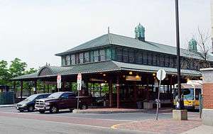 Dudley Square station in 2011 | |||||||||||||||||||||||||
| Location |
Washington Street at Dudley Street Roxbury, Boston, Massachusetts | ||||||||||||||||||||||||
| Coordinates | 42°19′45″N 71°05′03″W / 42.3292°N 71.0842°WCoordinates: 42°19′45″N 71°05′03″W / 42.3292°N 71.0842°W | ||||||||||||||||||||||||
| Owned by | Massachusetts Bay Transportation Authority | ||||||||||||||||||||||||
| Line(s) |
| ||||||||||||||||||||||||
| Construction | |||||||||||||||||||||||||
| Bicycle facilities | "Pedal and Park" bicycle cage | ||||||||||||||||||||||||
| Disabled access | Yes | ||||||||||||||||||||||||
| History | |||||||||||||||||||||||||
| Opened |
June 10, 1901 (Washington Street Elevated) July 20, 2002 (Silver Line)[1] | ||||||||||||||||||||||||
| Closed | April 30, 1987 (Washington Street Elevated)[1] | ||||||||||||||||||||||||
| Traffic | |||||||||||||||||||||||||
| Passengers (2013 daily) | 3,128 (Silver Line weekday boardings[2]) | ||||||||||||||||||||||||
| Passengers (2012 daily) | 30,000 (MBTA Bus weekday[3]) | ||||||||||||||||||||||||
| Services | |||||||||||||||||||||||||
| |||||||||||||||||||||||||
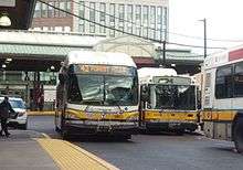
Dudley Square (variously known as Dudley Station, Dudley Street Terminal, or simply Dudley) is a ground-level bus station located in Dudley Square, Roxbury, Boston, Massachusetts, United States. It is a transfer point between 17 Massachusetts Bay Transportation Authority bus routes, including two Silver Line bus rapid transit lines and 15 local MBTA Bus routes. Like all MBTA bus stops, Dudley is fully handicapped-accessible.
Dudley was originally opened in 1901 as a BERy Main Line Elevated station. The last segment of the original Main Line Elevated, the Washington Street Elevated (including Dudley station), closed in 1987; six years later, Dudley was converted into its modern configuration. Silver Line service began in 2002.
Dudley is a contributing property in the Dudley Station Historic District, which was added to the National Register of Historic Places in 1985.
History
Original station
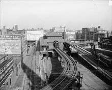
The Boston Elevated Railway opened its Main Line Elevated on June 10, 1901.[1] The line ran from Sullivan Square on the Charlestown Elevated, through the Tremont Street Subway, and on the Washington Street Elevated to a southern terminal located at Dudley Square. Along with the rest of the Washington Street Elevated, Dudley Street Terminal was designed by Alexander Wadsworth Longfellow, Jr.. It featured a Beaux Arts-style waiting area, clad in copper with an internal arched structure.[4]
Like many BERy stations, Dudley Street Terminal was designed for efficient transfers between streetcars and subway trains. Many streetcar routes that had operated to downtown (some into the Tremont Street Subway) were curtailed to Dudley, where two elevated loops offered cross-platform transfers to Main Line trains, using platforms on both sides of the northbound track. Other streetcars - largely on crosstown routes that did not terminate at Dudley - stopped at street-level platforms underneath the elevated station.
Modifications and decline
The Washington Street Elevated was extended south to Forest Hills on November 22, 1909.[1] The loop allowing trains to return downtown from Dudley was kept (as some trains were short-turned at Dudley), and a new southbound platform was added. In 1910, the elevated streetcar loops were expanded and roofed to handle larger-than-expected crowds. Dudley quickly became overcrowded; in 1917, a streetcar transfer area was built at Egleston to the south and some streetcar routes diverted there.[5]
As streetcar routes were bustituted during the 1940s and 1950s, the streetcar platforms were modified for use by buses and trackless trolleys. The east loop was completely rebuilt over a six-month period for trolleybus operations, reopening on December 25, 1948.[5] The Main Line Elevated was renamed the Orange Line in 1967.[1]
From 1979 to 1987, the Southwest Corridor was rebuilt, with 2 Orange Line and 3 commuter rail tracks in a trench replacing a 4-track embankment. Trains last ran on the Elevated on April 30, 1987, and the relocated Orange Line opened on May 4, 1987.[1]
Modern reuse
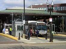
Even without the Elevated, Dudley Square remained a major bus transfer location. After several years, the former Elevated station was converted into a new bus station. The 784,000-pound (356,000 kg) station building was lowered 12 feet (3.7 m) to the ground and rolled 180 feet (55 m) to the south. The original station building covers north-south oriented bus platforms A, B, and C; new shelters in a similar style were built for east-west platforms D, E, and F. When completed in late 1993, the new Dudley Square bus station served over 10,000 daily passengers, with over 100 buses per hour stopping at peak times.[4]
When the Washington Street Elevated was removed, the MBTA originally promised to run light rail service over its former route. After 15 years of debate and changing plans, the Washington Street section of the Silver Line bus rapid transit system opened on July 20, 2002. It ran between Dudley and Downtown Crossing, replacing the #49 bus (albeit with increased frequency and other rapid-transit-like features).[1] On October 13, 2009, this service was re-designated the SL5; a new SL4 service was added between Dudley and South Station, sharing most of the route of the SL4.[1]
Future plans
Dudley Square was also a proposed stop on the MBTA's planned Urban Ring Project.[6] The Urban Ring was to be a Bus Rapid Transit (BRT) Line designed to connect the current MBTA Lines to reduce strain on the downtown stations. The project is currently shelved due to financial difficulties and questions about spending priorities.
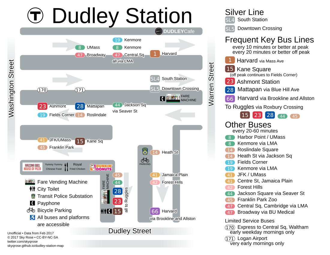
Service
- SL4 Dudley Station - South Station at Essex Street
- SL5 Dudley Station - Downtown Crossing at Temple Place
- 1* Harvard/Holyoke Gate - Dudley Station via Massachusetts Avenue (Boston)
- 8 Harbor Point/UMass - Kenmore Station via B.U. Medical Center & Dudley Station
- 14 Roslindale Square - Heath Street via Dudley Station, Grove Hall & Jackson Square Station
- 15* Kane Square or Fields Corner Station - Ruggles Station via Uphams Corner
- 19 Fields Corner Station - Kenmore or Ruggles Station via Grove Hall & Dudley Station
- 23* Ashmont Station - Ruggles Station via Washington Street
- 28* Mattapan Station - Ruggles Station via Dudley Station
- 41 Centre & Eliot Street - JFK/UMass Station via Dudley Station, Centre Street & Jackson Square Station
- 42 Forest Hills Station - Dudley or Ruggles Station via Washington Street
- 45 Franklin Park Zoo - Ruggles Station via Blue Hill Avenue
- 47 Central Square, Cambridge - Broadway Station via B.U. Medical Center, Dudley Station & Longwood Medical Area
- 66* Harvard Square - Dudley Station via Allston & Brookline Village
- 170 Central Square, Waltham - Dudley Square
- 171 Dudley Station - Logan Airport via Andrew Station
* designates one of the key MBTA bus routes, defined as the 15 busiest routes in the MBTA system.
References
- 1 2 3 4 5 6 7 8 Belcher, Jonathan (22 March 2014). "Changes to Transit Service in the MBTA district" (PDF). NETransit. Retrieved 24 October 2014.
- ↑ "Ridership and Service Statistics" (PDF) (14th ed.). Massachusetts Bay Transportation Authority. 2014.
- ↑ Ross, Casey (3 March 2012). "Dudley done right: City starts work on major rehab of a long-struggling Boston square". Boston Globe. Retrieved 23 October 2014.
- 1 2 Hopkinson, Peter; Parkinson, Kenneth (August 1995). "Intermodalism brings new life to old rail stations". The American City & Country. 110 (9): 20. Retrieved 23 October 2014 – via Proquest Historical Newspapers. (Subscription required (help)).
- 1 2 Cheney, Frank; Sammarco, Anthony M. (2000). When Boston Rode The El. Arcadia Publishing. pp. 109–118. ISBN 9780738504629.
- ↑ "Urban Ring Phase 2 FACT SHEET" (PDF). January 2009. Archived from the original (PDF) on 8 July 2011.
External links
| Wikimedia Commons has media related to Dudley Street Terminal. |