World Trade Center station (MBTA)
WORLD TRADE CTR | |||||||||||||||||||||||||||||
|---|---|---|---|---|---|---|---|---|---|---|---|---|---|---|---|---|---|---|---|---|---|---|---|---|---|---|---|---|---|
 World Trade Center Station platforms | |||||||||||||||||||||||||||||
| Location | Congress Street at C Street / World Trade Center Avenue, South Boston Waterfront | ||||||||||||||||||||||||||||
| Owned by | Massachusetts Bay Transportation Authority | ||||||||||||||||||||||||||||
| Line(s) | |||||||||||||||||||||||||||||
| Connections |
| ||||||||||||||||||||||||||||
| Construction | |||||||||||||||||||||||||||||
| Disabled access | Yes | ||||||||||||||||||||||||||||
| History | |||||||||||||||||||||||||||||
| Opened | December 17, 2004[1] | ||||||||||||||||||||||||||||
| Traffic | |||||||||||||||||||||||||||||
| Passengers (2009) | 2,338 (weekday average)[2] | ||||||||||||||||||||||||||||
| Services | |||||||||||||||||||||||||||||
| |||||||||||||||||||||||||||||
World Trade Center is a transportation station in Boston, Massachusetts, on the MBTA's bus rapid transit (BRT) Silver Line. The station is located on Congress Street at C Street/World Trade Center Avenue on the South Boston Waterfront. It is located between Boston's World Trade Center and Boston Convention and Exhibition Center (BCEC), near the Commonwealth Pier and a seasonal ferry to Provincetown, Massachusetts.
Station layout
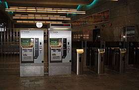
The station was designed by G plus G Architects. Its mezzanine level is intended to represent an underwater environment, with blue lighting, an undulating ceiling and sandy, mica-flecked stone tiles. Lenticular art designed by Marybeth Mungovan and Jason Asselin is installed on the lobby level of the station.
| G | Street level | Exit/entrance, connection to MBTA Route 4 |
| M | Mezzanine | Fare control |
| P Platform level |
Side platform, doors will open on the right | |
| Inbound | ← SL1, SL2, SL3 toward South Station (Courthouse) | |
| Outbound | SL1 toward Logan Airport (Silver Line Way) → SL2 toward Design Center (Silver Line Way) → SL3 toward Chelsea (Silver Line Way) → | |
| Side platform, doors will open on the right | ||
Nearby destinations

- Boston Convention and Exhibition Center (BCEC)
- Boston Harborwalk
- Commonwealth Pier and charter boats
- Institute of Contemporary Art, Boston (ICA)
- Restaurants
- Seaport Hotel and Seaport World Trade Center
- Seasonal ferry to Provincetown, Massachusetts
Future plans
World Trade Center Station is a stop on the MBTA's Silver Line Gateway service to Chelsea, Massachusetts, which opened April 2018.[3] In the future this route might be extended to the proposed Urban Ring Project, a Bus Rapid Transit (BRT) Line designed to connect the current MBTA Lines to reduce strain on the downtown stations.[4]
References
- ↑ Belcher, Jonathan (23 March 2013). "Changes to Transit Service in the MBTA district" (PDF). NETransit. Retrieved 12 August 2013.
- ↑ "Ridership and Service Statistics" (PDF). Massachusetts Bay Transportation Authority. 2010. Retrieved 12 August 2013.
- ↑ "Silver Line Gateway". Massachusetts Department of Transportation. Retrieved 30 October 2014.
- ↑ "Archived copy" (PDF). Archived from the original (PDF) on July 8, 2011. Retrieved March 18, 2012.
External links
Coordinates: 42°20′53.84″N 71°2′33.23″W / 42.3482889°N 71.0425639°W