Green Line "E" Branch
The "E" Branch (also referred to as the Huntington Avenue Branch, or formerly as the Arborway Branch) is a streetcar line in the Boston, Massachusetts area, operating as a branch of the Massachusetts Bay Transportation Authority Green Line. From 1985 to 2011, service beyond Heath Street (from VA Medical Center to the original outbound terminus at Arborway) was "temporarily" suspended, with the 39 bus providing service beyond; service restoration was officially canceled in 2011 after the defeat of a lawsuit. The segment of the line between Brigham Circle and Heath Street is the only remaining section of street-running tracks in regular use by the MBTA; all other trackage is in tunnels and bridges, on private rights-of-way, or in reserved medians.
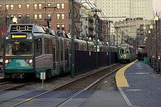
Northeast of the street-running section, the tracks run in the median of Huntington Avenue before descending via the Northeastern Incline into the Huntington Avenue Subway. Just west of Copley station, an underground flat junction connects the line into the other Green Line branches in the Boylston Street Subway, where they all run together to downtown. As of 2015, the "E" Branch is the only Green Line branch that regularly runs through to Lechmere Station.
History
Surface streetcar lines
The first street railway line to serve the area of the "E" Branch was built by the West Roxbury Railroad and immediately leased by the Metropolitan Railroad in 1857. The horse car line ran along Tremont Street from downtown, then continued south on Columbus Avenue, Centre Street and South Street to end at the Jamaica Plain Carhouse in Jamaica Plain. Paralleling this to the east was a Metropolitan Railroad line along Washington Street from Dudley out to Forest Hills.
Those tracks were electrified in 1891 and in 1902 they were extended the last bit to the Arborway Carhouse, connecting the line to the tracks along Washington Street and establishing Arborway as a transfer point. In 1903 Arborway trains began running into the subway.
Tracks that later became part of the "E" Branch were built in 1859 along Huntington Avenue from Brigham Circle west into Brookline, as part of a branch from the original Jamaica Plain route, later used by the 66 route. A new cutoff was built from this route via Huntington Avenue ca. 1883, allowing cars to run to Park Square via existing tracks on Boylston Street. In 1906 the connection along South Huntington Avenue was built to connect this newer route on Huntington to the older route on Centre. Additionally, between 1888 and 1897, the "Dudley Street Crossover" was built along Centre Street (moved to Roxbury Street by 1925) to connect the line to an existing loop west from Dudley to Eliot Square. This allowed Jamaica Plain cars to run to Dudley and towards downtown from there.

The Huntington Avenue line was electrified in 1894. The Boylston Street Incline to the Tremont Street Subway opened on September 1, 1897 as part of the first section of subway, and Huntington Avenue cars were rerouted into it (though those cars didn't use the Jamaica Plain line until 1903 – see above). Tremont Street cars were likely moved to the subway on October 1, 1897, when the next section of subway to the Pleasant Street Incline opened, though from June 10, 1901 to November 29, 1908 that portal was closed to all but Washington Street Elevated trains.
The Washington Street Elevated opened June 10, 1901 to Dudley and many streetcar routes that had operated via Dudley were truncated there with a transfer to the El. This included the Jamaica Plain route via Dudley. The extension of the Elevated to Forest Hills (adjacent to Arborway) on November 22, 1909 provided a faster route downtown from Arborway (above the Washington Street streetcar lines), but the Jamaica Plain cars used a completely different route to get there.
The tracks on Huntington Avenue from Brookline to South Huntington Avenue were last used on September 9, 1938 by cars from Brookline Village into the subway, as well as what became the 66 Allston – Dudley bus (this was also the last use of the tracks on Tremont Street west of Columbus Avenue). The cars from Brookline Village had been truncated from earlier lines running further into Brookline (later the 58 and 60 buses) and on September 10 they started running as short-turn trips on Huntington Avenue to Brigham Circle.
Huntington Avenue Subway

The Huntington Avenue Subway opened on February 16, 1941, taking Huntington Avenue cars (the last to use the Boylston Street Portal) underground for a larger part of their route.
The final pattern of streetcars serving the line was:
- 39 from Arborway into the subway via Huntington Avenue, with short-turn cars to Northeastern University and Brigham Circle
- 41 from the Jamaica Plain Carhouse to Dudley via Columbus Avenue
- 57 from a short-turn loop at Heath Street into the subway via Huntington Avenue
Service straight through to downtown on Columbus Avenue and Tremont Street was only provided by 43 cars, which began at Egleston Square (also the location of a Washington Street Elevated station) and continued into the subway at the Pleasant Street Incline, using the same tracks as the 41 for a section.
The 41 last ran streetcars on June 7, 1949, and the 43 cars last ran to Egleston June 14, 1956, leaving only the 39 and 57. In 1967 these lines were redesignated as the "E" Branch of the Green Line, with short-turn Heath Street service on rollsigns with a slash through the E.
Over the years, due to shortages in cars[2] (especially caused by the opening and popularity of the Green Line "D" Branch), sections of the line were replaced by bus service; the bus was always referred to as the 39 and ran to Copley with free transfers. The final day of streetcars to Arborway was December 27, 1985. In December 1989 the 39 route was extended to Back Bay (with free transfers to the Orange Line), the southern end was renamed Forest Hills and the fare structure was changed from Green Line fares to normal bus fares. (As of January 1, 2007, all Green Line fares are the same as for the other subway lines, as part of a system-wide streamlining and simplification of fare structure. System wide, bus-to-subway and subway-to-bus transfers are free with paid subway fare, for users of the plastic CharlieCard only.)
Service changes

The following service changes have been made since 1961:
- Before September 11, 1961: Arborway cars and short-turn Northeastern University cars ran to Park Street, short-turn Heath Street cars ran to North Station
- September 11, 1961: Heath Street short-turn cars discontinued, with all cars looping at Park Street
- December 26, 1964: Heath Street short-turn cars readded weekdays and Saturdays from 06:30 to 09:00 and 13:30 to 17:30, turning at Government Center
- January 1965: Heath Street short-turn cars cut back to Park Street
- March 25, 1967: Heath Street short-turn cars extended to Government Center
- June 24, 1967: Heath Street short-turn Saturday cars discontinued
- March 19, 1977: Heath Street short-turn cars extended to North Station
- June 18, 1977: Heath Street short-turn cars cut back to Government Center
- March 22 1980: E line shut down from Northeastern to Arborway. There was shuttle provided from North Station to Symphony
- June 21, 1980: Service restored to Northeastern, using all LRV trains
- September 20, 1980: Service extended to Brigham Circle
- June 26, 1982: after closures for rebuilding, full service reopens, with Arborway and Heath Street (rush hours only) cars running to Park Street, and no more Northeastern University short-turn cars
- January 2, 1983: Heath Street short-turn service extended to middays and extended to Lechmere
- February 11, 1983: Heath Street short-turn cars cut back to Park Street
- December 28, 1985: Service from Heath Street to Arborway "temporarily" replaced by 39 bus, and short-turn cars also replaced for track reconstruction leaving entire "E" line closed
- July 26, 1986: Service restored to Brigham Circle, running to Lechmere weekdays and Government Center nights and weekends
- June 20, 1987: Extended to Lechmere all times
- November 4, 1989: Service restored to Heath Street with completion of reconstruction
- June 28, 2004: Cut back to new North Station station during construction of new tunnel towards Lechmere; went only to Haymarket on June 26 and June 27
- November 12, 2005: Extended to Lechmere all times
- September 2, 2006: Cut back from Heath Street to Brigham Circle due to a track improvement project
- December 30, 2006: Service restored to Heath Street with completion of reconstruction
- 2008: Tracks from Heath Street to Arborway now fully paved over
- July 1, 2012: Weekend service cut back from Heath Street to Brigham Circle
- October 2012: Weekend service restored to Heath Street[3]
Arborway restoration controversy


To settle a lawsuit with the Conservation Law Foundation the Massachusetts Executive Office of Transportation and Construction (EOTC) agreed to environmental mitigation for increased automobile emissions due to the Central Artery/Tunnel Project (CA/T). In 2000, an Administrative Consent Order (ACO) affirmed specific project commitments, including restoration of streetcar service beyond Heath Street to Arborway. Restoration was also included in the State Implementation Plan for the Clean Air Act (SIP) which is required by the Environmental Protection Agency due to non-attainment of National Ambient Air Quality Standards.[4][5]
After some MBTA and community opposition, a revised settlement resulted in the substitution of other projects with similar regional air quality benefits, though no longer localized along the "E" branch corridor. EOTC promised to consider other transit enhancements in the Arborway corridor.[6] Community activists continued lobbying for streetcar restoration; however, trackage south of Heath Street was paved over in 2008. The Arborway Committee filed suit in 2007, but an appeals court ruled in January 2011 that the lawsuit was a decade too late to be considered – effectively ending any attempt for the restoration of streetcar service for the foreseeable future.[7] The City of Boston has proposed extending the E Branch southward to Hyde Square in Jamaica Plain.[8]
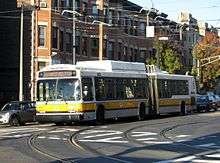
The 39 Forest Hills Station – Back Bay Station via Huntington Avenue bus provides all service beyond Heath Street. The route overlaps with the remaining streetcar service and is used as a backup during service disruptions.
Station listing
| Station | Location | Transfers and notes |
|---|---|---|
| Huntington Avenue near Belvidere Street | MBTA Bus: 39, 55 | |
| Symphony | Huntington Avenue at Massachusetts Avenue | MBTA Bus: 1, 39, CT1 |
| Huntington Avenue at Opera Place | MBTA Bus: 39 | |
| Huntington Avenue at Ruggles Street | MBTA Bus: 8, 19, 39, 47, CT2, CT3 | |
| Huntington Avenue at Longwood Avenue | MBTA Bus: 39, CT2 | |
| Huntington Avenue at Francis Street | MBTA Bus: 39, 66, MIS Last outbound stop in reserved median - street running further outbound | |
| Fenwood Road | Huntington Avenue at Fenwood Road | MBTA Bus: 39, 66 |
| Mission Park | Huntington Avenue at Mission Park | MBTA Bus: 39, 66 |
| Riverway | South Huntington Avenue at Huntington Avenue | MBTA Bus: 39, 66 |
| Back of the Hill | South Huntington Avenue near Heath Street | MBTA Bus: 39 |
| South Huntington Avenue at Heath Street | MBTA Bus: 14, 39 |
References
- ↑ Belcher, Jonathan (23 March 2013). "Changes to Transit Service in the MBTA district" (PDF). NETransit. Retrieved 6 August 2013.
- ↑ Scott Moore (2007-02-22). "Boston's Green Line Crisis". members.aol.com/netransit. Archived from the original on 2007-02-22. Retrieved 2012-06-24.
- ↑ Rocheleau, Matt (28 December 2012). "MBTA reinstates weekend trolley service for entire E branch of the Green Line". Boston Globe. Retrieved 28 December 2012.
- ↑ (PDF) https://web.archive.org/web/20050412083019/http://www.ctps.org/bostonmpo/pmt/PMT-ES.pdf. Archived from the original (PDF) on April 12, 2005. Retrieved May 23, 2005. Missing or empty
|title=(help) - ↑ https://web.archive.org/web/20050605023535/http://www.mass.gov/dep/bwp/daqc/files/regs/7c.htm. Archived from the original on June 5, 2005. Retrieved May 23, 2005. Missing or empty
|title=(help) - ↑ Ruch, John (March 7, 2008). "State suggests Route 39 changes". Jamaica Plain Gazette. Retrieved April 1, 2015.
- ↑ Ruch, John (26 August 2011). "Trolley comeback killed by court". Jamaica Plain Gazette. Retrieved 19 February 2013.
- ↑ "Go Boston 2030 Vision and Action Plan" (PDF). 7 March 2017. Retrieved 14 March 2017.
External links
| Wikimedia Commons has media related to Green Line "E" Branch. |
- MBTA – Green Line "E" Branch
- MBTA – Arborway Restoration Project
- Arborway Rail Restoration Project Advisory Committee (ARRPAC), empaneled by the MBTA in early 2002 to review and guide restoration project
- The Arborway Committee, seeking enforcement of restoration requirement