HealthLine
|
| ||||||||||||||||||||||||||||||||||||||||||||||||||||||||||||||||||||||||||||||||||||||||||||||||||||||||||||||||||||||||||||||||||||||||||||||||||||||||||||||||||||||||||||||||||||||||||||||||||||||||||||||||||||||||||||||||||||||||||||||||||||||||||||||||||||||||||||||||||||||||||||||||||||||||||||||||||||||||||||||||||||||
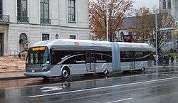 A HealthLine rapid transit vehicle drives through University Circle. | ||||||||||||||||||||||||||||||||||||||||||||||||||||||||||||||||||||||||||||||||||||||||||||||||||||||||||||||||||||||||||||||||||||||||||||||||||||||||||||||||||||||||||||||||||||||||||||||||||||||||||||||||||||||||||||||||||||||||||||||||||||||||||||||||||||||||||||||||||||||||||||||||||||||||||||||||||||||||||||||||||||||
| Overview | ||||||||||||||||||||||||||||||||||||||||||||||||||||||||||||||||||||||||||||||||||||||||||||||||||||||||||||||||||||||||||||||||||||||||||||||||||||||||||||||||||||||||||||||||||||||||||||||||||||||||||||||||||||||||||||||||||||||||||||||||||||||||||||||||||||||||||||||||||||||||||||||||||||||||||||||||||||||||||||||||||||||
| System | Greater Cleveland Regional Transit Authority | |||||||||||||||||||||||||||||||||||||||||||||||||||||||||||||||||||||||||||||||||||||||||||||||||||||||||||||||||||||||||||||||||||||||||||||||||||||||||||||||||||||||||||||||||||||||||||||||||||||||||||||||||||||||||||||||||||||||||||||||||||||||||||||||||||||||||||||||||||||||||||||||||||||||||||||||||||||||||||||||||||||
| Status | Operating | |||||||||||||||||||||||||||||||||||||||||||||||||||||||||||||||||||||||||||||||||||||||||||||||||||||||||||||||||||||||||||||||||||||||||||||||||||||||||||||||||||||||||||||||||||||||||||||||||||||||||||||||||||||||||||||||||||||||||||||||||||||||||||||||||||||||||||||||||||||||||||||||||||||||||||||||||||||||||||||||||||||
| Began service | October 24, 2008 | |||||||||||||||||||||||||||||||||||||||||||||||||||||||||||||||||||||||||||||||||||||||||||||||||||||||||||||||||||||||||||||||||||||||||||||||||||||||||||||||||||||||||||||||||||||||||||||||||||||||||||||||||||||||||||||||||||||||||||||||||||||||||||||||||||||||||||||||||||||||||||||||||||||||||||||||||||||||||||||||||||||
| Routes | ||||||||||||||||||||||||||||||||||||||||||||||||||||||||||||||||||||||||||||||||||||||||||||||||||||||||||||||||||||||||||||||||||||||||||||||||||||||||||||||||||||||||||||||||||||||||||||||||||||||||||||||||||||||||||||||||||||||||||||||||||||||||||||||||||||||||||||||||||||||||||||||||||||||||||||||||||||||||||||||||||||||
| Routes | 1 | |||||||||||||||||||||||||||||||||||||||||||||||||||||||||||||||||||||||||||||||||||||||||||||||||||||||||||||||||||||||||||||||||||||||||||||||||||||||||||||||||||||||||||||||||||||||||||||||||||||||||||||||||||||||||||||||||||||||||||||||||||||||||||||||||||||||||||||||||||||||||||||||||||||||||||||||||||||||||||||||||||||
| Locale | Cleveland, Ohio | |||||||||||||||||||||||||||||||||||||||||||||||||||||||||||||||||||||||||||||||||||||||||||||||||||||||||||||||||||||||||||||||||||||||||||||||||||||||||||||||||||||||||||||||||||||||||||||||||||||||||||||||||||||||||||||||||||||||||||||||||||||||||||||||||||||||||||||||||||||||||||||||||||||||||||||||||||||||||||||||||||||
| Start | Public Square | |||||||||||||||||||||||||||||||||||||||||||||||||||||||||||||||||||||||||||||||||||||||||||||||||||||||||||||||||||||||||||||||||||||||||||||||||||||||||||||||||||||||||||||||||||||||||||||||||||||||||||||||||||||||||||||||||||||||||||||||||||||||||||||||||||||||||||||||||||||||||||||||||||||||||||||||||||||||||||||||||||||
| End | Louis Stokes Station at Windermere | |||||||||||||||||||||||||||||||||||||||||||||||||||||||||||||||||||||||||||||||||||||||||||||||||||||||||||||||||||||||||||||||||||||||||||||||||||||||||||||||||||||||||||||||||||||||||||||||||||||||||||||||||||||||||||||||||||||||||||||||||||||||||||||||||||||||||||||||||||||||||||||||||||||||||||||||||||||||||||||||||||||
| Length | 6.8 mi (11 km) | |||||||||||||||||||||||||||||||||||||||||||||||||||||||||||||||||||||||||||||||||||||||||||||||||||||||||||||||||||||||||||||||||||||||||||||||||||||||||||||||||||||||||||||||||||||||||||||||||||||||||||||||||||||||||||||||||||||||||||||||||||||||||||||||||||||||||||||||||||||||||||||||||||||||||||||||||||||||||||||||||||||
| Stations | 59 | |||||||||||||||||||||||||||||||||||||||||||||||||||||||||||||||||||||||||||||||||||||||||||||||||||||||||||||||||||||||||||||||||||||||||||||||||||||||||||||||||||||||||||||||||||||||||||||||||||||||||||||||||||||||||||||||||||||||||||||||||||||||||||||||||||||||||||||||||||||||||||||||||||||||||||||||||||||||||||||||||||||
| Service | ||||||||||||||||||||||||||||||||||||||||||||||||||||||||||||||||||||||||||||||||||||||||||||||||||||||||||||||||||||||||||||||||||||||||||||||||||||||||||||||||||||||||||||||||||||||||||||||||||||||||||||||||||||||||||||||||||||||||||||||||||||||||||||||||||||||||||||||||||||||||||||||||||||||||||||||||||||||||||||||||||||||
| Daily ridership | 14,367 [1] | |||||||||||||||||||||||||||||||||||||||||||||||||||||||||||||||||||||||||||||||||||||||||||||||||||||||||||||||||||||||||||||||||||||||||||||||||||||||||||||||||||||||||||||||||||||||||||||||||||||||||||||||||||||||||||||||||||||||||||||||||||||||||||||||||||||||||||||||||||||||||||||||||||||||||||||||||||||||||||||||||||||
| ||||||||||||||||||||||||||||||||||||||||||||||||||||||||||||||||||||||||||||||||||||||||||||||||||||||||||||||||||||||||||||||||||||||||||||||||||||||||||||||||||||||||||||||||||||||||||||||||||||||||||||||||||||||||||||||||||||||||||||||||||||||||||||||||||||||||||||||||||||||||||||||||||||||||||||||||||||||||||||||||||||||
The HealthLine (formerly known as the Silver Line[2] and as the Euclid Corridor Transportation Project) is a bus rapid transit (BRT) line run by the Greater Cleveland Regional Transit Authority in Cleveland, Ohio, United States. The line runs along Euclid Avenue from Public Square in downtown Cleveland to the Louis Stokes Station at Windermere in East Cleveland. It began operation on October 24, 2008.[3] Its current name was the result of a naming rights deal with the Cleveland Clinic and University Hospitals of Cleveland.[4] The HealthLine is denoted with a silver color and abbreviated simply as HL on most RTA publications.
By late 2009, ridership had expanded 47 percent compared to the former line running along the same route prior to the completion of the Euclid Corridor project and the creation of the HealthLine.[5]
The Healthline is the top rated BRT system in the United States with a Silver rating according to the BRT Standard.[6]
Route description
The HealthLine route travels 6.8 miles (11 km) along Euclid Avenue from Public Square in Downtown Cleveland to Louis Stokes Station at Windermere in East Cleveland. It passes through the neighborhoods of Downtown, Midtown, Fairfax, University Circle and the suburb of East Cleveland.[3]
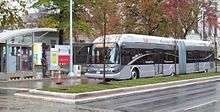
There are 59 stations along Euclid Avenue that serve the HealthLine. All stations are equipped with a fare card vending machine, 24-hour lighting and an emergency phone. An illuminated text display informs passengers of expected arrival times. Between Public Square and East 107th Street, all stations have raised platforms that align with the floor of the rapid transit vehicle, easing boarding and alighting.[7]
Between Public Square and East 105th Street, Euclid Avenue has two "bus only" lanes close to the inner median which only allow HealthLine vehicles passage, reducing delays due to conflicts with general traffic during busy times. Complementing the HealthLine is a set of bike lanes on the outer edges of the stretch Euclid Avenue that connects Cleveland State University with Case Western Reserve University.[8]
As late as July 2010, the trip from East Cleveland to downtown during rush hour was more than 40 minutes – longer than the planned 33 minutes. This was due to traffic light timing and the 25 mph speed limit along most of the route. The speed limit was raised to 35 mph for buses and traffic light timing was adjusted further to combat this issue.[9][10]
The decision to turn off signal priority along portions of the line has been referred to as a form of BRT creep.[11]
Bus fleet
The HealthLine runs a fleet of 21 articulated DE63LFA-BRT vehicles, manufactured by New Flyer Industries, each with a seating capacity of 47 and able to accommodate 53 more standing up. The vehicles have two doors on each side and run on a diesel-electric hybrid motor system that produce 90% less emissions than regular buses.[12][13] A low sulfur diesel engine (Caterpillar C-9) generates electrical power to run smaller electric motors mounted on each of the wheels.[14] Each vehicle also has a GPS locator on board, which allows automated traffic signals to give the HealthLine buses priority at busy intersections.
Bus stops
The RTA classifies its bus rapid transit stops as "curb stations" and "median stations". The term "station" is used because RTA considers the route to be part of the rapid transit system.
Schedule
| Weekdays (Monday–Friday) | |||
|---|---|---|---|
| Eastbound | Westbound | ||
| 3:10 AM–5:10 AM | Every 30 minutes | 2:58 AM– 4:28 AM | Every 30 minutes |
| 5:10 AM–6:10 AM | Every 15 minutes | 4:28 AM–5:27 AM | Every 15 minutes |
| 6:10 AM–7:10 AM | Every 10 minutes | 5:27 AM–6:23 AM | Every 10 minutes |
| 7:10 AM–6:10 PM | Every 7–8 minutes | 6:23 AM–5:32 PM | Every 7–9 minutes |
| 6:10 PM–7:10 PM | Every 10 minutes | 5:32 PM–6:22 PM | Every 10 minutes |
| 7:10 PM–11:40 PM | Every 15 minutes | 6:22 PM–10:55 PM | Every 15 minutes |
| 11:40 PM–2:40 AM | Every 30 minutes | 10:55 PM– 2:28 AM | Every 30 minutes |
| Saturdays / Sundays / Holidays | |||
| Eastbound | Westbound | ||
| 3:10 AM–4:40 AM | Every 30 minutes | 2:58 AM–3:58 AM | Every 30 minutes |
| 4:40 AM–11:40 PM | Every 15 minutes | 3:58 AM–10:54 PM | Every 15 minutes |
| 11:40 PM–2:40 AM | Every 30 minutes | 10:54 PM–2:28 AM | Every 30 minutes |
Stations
| Station | Platform (doors open) | Notes | Coordinates | |
|---|---|---|---|---|
| Downtown Cleveland | ||||
| Public Square/West Roadway (eastbound) | curb (left) | West side of Public Square | ||
| Public Square/Tower City (eastbound) | curb (left) | Official western terminus of HealthLine. South end of Public Square (South Roadway & Ontario intersection). Connections: RTA Rapid Transit lines at Tower City station, most RTA bus lines serving downtown (including trolley bus lines) and Public Square. | ||
| East 2nd Street | median (left) | East of Public Square. Westernmost station on Euclid Avenue and on exclusive BRT right of way. Serves The Arcade. | ||
| East 6th Street | median (left) | East of intersection with East 6th Street. | 41°30′0″N 81°41′20″W / 41.50000°N 81.68889°W | |
| East 9th Street | median (left) | East of intersection with East 9th Street. Serves Playhouse Square | 41°30′01″N 81°41′10″W / 41.50028°N 81.68611°W | |
| East 14th Street | median (left) | Between East 13th and 14th intersections. Serves Playhouse Square and TV station WVIZ Ideastream. | ||
| East 19th Street | 2 median (right) | At intersection with East 19th ( campus walkway) Serves Cleveland State University. | ||
| East 24th Street | 2 median (right) | At intersection with East 24th Serves Cleveland State University. Walking distance of Stephanie Tubbs Transit Center | ||
| Midtown district | ||||
| East 30th Street | 2 median (right) | At intersection with East 30th | ||
| East 36th Street | 2 median (right) | At intersection with East 36th | ||
| East 40th Street | 2 median (right) | At intersection with East 40th Serves Children's Museum of Cleveland. | ||
| East 51st Street | 2 median (right) | Between East 45th and East 55th intersections Serves The Agora | ||
| East 59th Street | 2 median (right) | At intersection with East 59th Connections: RTA bus route 16 | ||
| East 66th Street | 2 median (right) | At intersection with East 66th Bordering the Hough and Central neighborhoods | ||
| East 71st Street | 2 median (right) | At intersection with East 71st | ||
| Fairfax district | ||||
| East 79th Street | 2 median (right) | At intersection with East 79th Connections: RTA bus route 2 | ||
| East 83rd Street | 2 median (right) | At intersection with East 83rd | ||
| East 89th Street | 2 median (right) | At intersection with East 89th | ||
| East 93rd Street | 2 median (right) | At intersection with East 93rd Serves Cleveland Clinic Connections: RTA bus routes 7, 9, 32, 48, 48A | ||
| East 100th Street | 2 median (right) | At intersection with East 100th Sunday service only No station canopy | ||
| University Circle | ||||
| East 105th Street | 2 median (right)) | At intersection with East 105th Connections: RTA bus route 10 Serves Cleveland Public Library MLK branch, Ronald McDonald House Easternmost stop on exclusive BRT right-of-way | ||
| Stokes/Stearns | 2 curb (right) | Westbound stop at Stokes Boulevard; eastbound stop at Stearns Road Connections: RTA bus routes 7, 9, 32, 48, 48A | ||
| Adelbert Road | 2 curb (right) | Located east of Adelbert Road Serves Case Western Reserve University | 41°30′24″N 81°36′29″W / 41.50667°N 81.60806°W | |
| Cornell Road | 2 curb (right) | Located west of Cornell Road Serves University Hospitals Connections: RTA bus route 9 | 41°30′29″N 81°36′23″W / 41.50806°N 81.60639°W | |
| East 115th Street | 2 curb (right) | At intersection with East 115th Serves Cleveland Institute of Art Connections: RTA bus route 38 | ||
| East 118th Street | 2 curb (right) | At intersection with East 118th | ||
| East 123rd Street | 2 curb (right) | East of East 123rd intersection | Connections: RTA bus route 38. Formerly connected with the RTA Red Line at Euclid–East 120th station (closed 2015) | |
| East Cleveland | ||||
| Lakeview Road | 2 curb (right) | At Lakeview Road intersection Connections: RTA bus route 38 | ||
| Delmont Avenue (westbound) | curb (right) | West of Delmont Avenue intersection | ||
| Roxbury Road (eastbound) | curb (right) | West of Roxbury Road intersection | ||
| Emily Street (westbound) | curb (right) | West of Emily/Rosalind intersection | ||
| Garfield Road (eastbound) | curb (right) | At Garfield Road intersection | ||
| Superior Avenue | 2 curb (right) | East of Superior Avenue intersection Adjacent to the Superior Avenue station Connections: RTA Red Line, bus routes 3 and 40 | ||
| Eddy Road (westbound) | curb (right) | At Eddy/Wellesley intersection | ||
| Wellesley Avenue (eastbound) | curb (right) | At Eddy/Wellesley intersection | ||
| Lakefront Road (westbound) | curb (right) | At Lakefront intersection | ||
| Belmore Avenue (eastbound) | curb (right) | At Belmore intersection Last eastbound station on Euclid Avenue | ||
| Debra Ann Lane (westbound) | curb (right) | At Debra Ann Lane intersection First westbound station on Euclid Avenue | ||
| Louis Stokes Station at Windermere (or Stokes–Windermere) | curb (right) | Eastern terminus of HealthLine Connections: RTA Red Line (eastern terminus), bus lines 3, 28, 28A, 30, 37, 41, 41F | 41°31′50″N 81°35′6″W / 41.53056°N 81.58500°W | |
 Public Square/West Roadway
 Public Square/Tower City
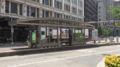 East 2nd Street
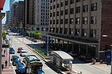 East 6th Street
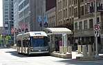 East 9th Street
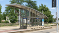 East 66th Street
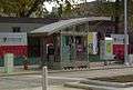 Adelbert Road
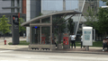 Cornell Road
 Louis Stokes Station at Windermere
See also
References
- ↑ http://www.metroplanning.org/news-events/blog-post/6203; Accessed: February 28, 2012
- ↑ Clinic, UH pay to name Euclid Corridor buses. The Plain Dealer. Retrieved on March 4, 2008.
- 1 2 "Where it goes" - http://www.gcrta.org/healthline/healthline-flash.html
- ↑ "Greater Cleveland Regional Transit Authority". www.riderta.com. Retrieved 2015-04-12.
- ↑ Litt, Steven (2009-11-29). "RTA's Euclid Avenue HealthLine is faring well in ridership, innovation". The Plain Dealer. Retrieved 2009-11-30.
- ↑ Malouff, Dan (2013-01-17). "The US has only 5 true BRT corridors, and none are "gold"". Greater Greater Washington. Retrieved 2013-04-19.
- ↑ "What it is - Station" - http://www.gcrta.org/healthline/healthline-flash.html
- ↑ Rapid Transit Vehicles - http://euclidtransit.org/rapid_transit_system/euclid_corridor_vehicles.asp
- ↑ McIntyre, Michael (17 July 2010). "Cleveland allows RTA buses to drive faster on Euclid Avenue". Cleveland Plain Dealer. Retrieved 1 August 2010.
- ↑ Farkas, Karen (6 July 2010). "HealthLine buses moving slower than expected on Euclid Avenue". Cleveland Plain Dealer Blog. Retrieved 1 August 2010.
- ↑ Ross, Benjamin. "Big Philanthropy Takes the Bus". Dissent Magazine. Dissent Magazine. Retrieved 5 October 2016.
- ↑ RTA HealthLine - http://www.gcrta.org/healthline/healthline-flash.html
- ↑ "What it is - Vehicle" - http://www.gcrta.org/healthline/healthline-flash.html
- ↑ Euclid Corridor Transportation Project - http://euclidtransit.org/rapid_transit_system/euclid_corridor_vehicles.asp
- ↑ "Schedule Effective April 21, 2013" - http://www.riderta.com/sites/default/files/schedule-pdfs/HealthLine.pdf
External links
| Wikimedia Commons has media related to HealthLine. |