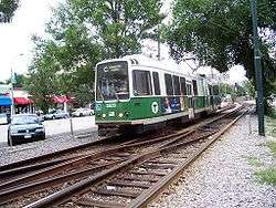
Green Line "C" Branch

The "C" Branch, also called the Beacon Street Line or Cleveland Circle Line, is one of four branches of the Massachusetts Bay Transportation Authority's Green Line light rail system in the Boston, Massachusetts metropolitan area. The line begins at Cleveland Circle in the Brighton neighborhood of Boston and runs on the surface through Brookline along the median of Beacon Street. Reentering Boston, the line goes underground through the St. Marys Street Incline and joins the "B" and "D" Branches at Kenmore. Trains run through the Boylston Street Subway to Copley where the "E" Branch joins, then continue through the Tremont Street Subway to downtown Boston. As of 2017, the "C" Branch terminates at North Station; further service to Lechmere is provided by the "E" Branch.
Traffic signals

The "C" branch runs on a dedicated median on Beacon Street in Brookline, with a total of 18 grade crossings at major cross streets.[2] Like on its sister "B" branch, "C" branch streetcars must stop on traffic signals at street crossings. The signals on Beacon Street in Brookline could in theory be prioritized to make the Green Line run faster. However, the MBTA, which would be expected to pay for the streetcar sensors, does not consider the project to be cost-effective.[3] In 2007, the Boston Globe published letters from riders who are in favor of these sensors,[4] a letter from the MBTA spokesperson arguing that a major study is needed before the MBTA spends money,[5] and a letter arguing that the T's spokesperson is giving too many excuses.[6]
In January 2008, the MBTA hired a consultant to study the issue.[7] As of 2011, the Town of Brookline was considering formally asking the MBTA to cooperate in setting up traffic signal prioritization to speed up Green Line trains on Beacon Street.[8]
In Mayor Marty Walsh's "Go Boston 2030" plan, prioritizing traffic signals on Beacon Street was a proposed idea. The plan indicated that the project is planned to be completed within five years.[9]
History


The first tracks on Beacon Street were laid in 1888, running from Massachusetts Avenue west to Coolidge Corner. The next year the rest of the line to Cleveland Circle opened, with access to the Reservoir Carhouse. In 1889, the first electric streetcar route (see Green Line "A" Branch) used Beacon Street from Coolidge Corner east to Massachusetts Avenue, then ran south on Massachusetts Avenue and east on Boylston Street to Park Square. That same year the line on Beacon Street to Cleveland Circle was electrified.
Another connection to the Beacon Street line was provided at Washington Square; streetcars came from Brookline Village along Washington Street and turned west on Beacon Street. This line was later extended north on Chestnut Hill Avenue and west on Commonwealth Avenue to Boston College and was the predecessor of the 65 bus route.
On September 1, 1897, the Tremont Street Subway opened and then or soon after Beacon Street service began to run into it via the Boylston Street Portal at the Public Garden, turning around at Park Street. On October 3, 1914, the Boylston Street Subway extended the underground portion to the Kenmore Incline just east of Kenmore Square, and the underground Kenmore and the St. Marys Street Incline extended it west on October 23, 1932.
Until 1967, when it was named the "C" Branch, the Beacon Street route had the map number 61.
Beacon Street service was extended from Park Street to Lechmere on February 7, 1931. Since then, Beacon Street service has had the following east terminals:[10]
- November 20, 1961: cut back from Lechmere to North Station all but Sundays
- March 25, 1967: extended to Lechmere all times
- June–September 1968: cut back to Government Center Sundays, restored to Lechmere afterwards
- March 21, 1980: cut back to Government Center all but rush hours
- June 21, 1980: extended to Lechmere all times
- April 4, 1981: cut back to Park Street
- June 26, 1982: extended to Government Center
- July 30, 1983: extended to North Station
- March 28, 1997: cut back to Government Center
- January 1, 2005: extended to North Station
As of 2017, regular C service terminates at North Station.
Station listing

.JPG)
| Station | Location | Time to Park Street[11] | Transfers and notes |
|---|---|---|---|
| North Station to Kenmore segment shared by other Green Line branches | |||
| Beacon Street at St. Marys Street | 19 minutes | CT2 bus to Sullivan or Ruggles | |
| Hawes Street | Beacon Street at Hawes Street | 20 minutes | |
| Kent Street | Beacon Street at Powell Street | 21 minutes | |
| St. Paul Street | Beacon Street at St. Paul Street | 22 minutes | |
| Beacon Street at Harvard Street | 24 minutes | 66 Bus to Harvard Square or Dudley | |
| Summit Avenue | Beacon Street at Summit Avenue | 25 minutes | Used to be named Winchester Street. |
| Brandon Hall | Beacon Street across from Brandon Hall | 26 minutes | |
| Fairbanks | Beacon Street at Fairbanks Avenue | 27 minutes | |
| Beacon Street at Washington Street | 28 minutes | 65 Bus to Kenmore Square or Brighton Center | |
| Tappan Street | Beacon Street at Tappan Street | 29 minutes | |
| Dean Road | Beacon Street at Dean Road | 30 minutes | |
| Englewood Avenue | Beacon Street at Englewood Avenue | 31 minutes | |
| Beacon Street at Chestnut Hill Avenue | 32 minutes | Nearby to Reservoir and Chestnut Hill Avenue stations | |
No stations on the "C" Branch have MBTA parking, although some have a small number of locally controlled parking spots. The only stations with MBTA parking served by "C" streetcars are North Station and Haymarket, which also serve "E" Branch streetcars.[12]
All of the street-level "C" branch stations from St. Marys Street to Englewood Avenue are in Brookline; all the underground subway stops and the Cleveland Circle terminus in the Brighton neighborhood are in Boston.
References
- ↑ "Ridership and Service Statistics" (PDF) (13th ed.). Massachusetts Bay Transportation Authority. 2010. Retrieved 31 July 2011.
- ↑ "Google Maps". Google Inc. 2011. Retrieved 27 September 2011.
- ↑ Masis, Julie (2 December 2007). "Beacon gets smart lights, but T isn't along for the ride". The Boston Globe. Retrieved 31 July 2011.
- ↑ "Letters". The Boston Globe. 9 December 2007. Retrieved 31 July 2011.
- ↑ "Letters". The Boston Globe. 16 December 2007. Retrieved 31 July 2011.
- ↑ "Letters". The Boston Globe. 30 December 2007. Retrieved 31 July 2011.
- ↑ Masis, Julie (27 January 2008). "T may get edge on Beacon St". The Boston Globe. Retrieved 31 July 2011.
- ↑ Parker, Brock (January 11, 2011). "Brookline mulling how to speed up C Line along Beacon Street". boston.com (The Boston Globe). Retrieved 2011-08-02.
- ↑ "Go Boston 2030 Full Plan" (PDF). 7 March 2017. p. 168. Retrieved 7 August 2017.
- ↑ Belcher, Jonathan (20 July 2011). "Changes to Transit Service in the MBTA district" (PDF). Retrieved 31 July 2011.
- ↑ Association for Public Transportation, Car-Free in Boston, A Guide for Locals and Visitors, 10th ed. (2003), p. 117.
- ↑ "Green Line: Cleveland Circle (C)". Massachusetts Bay Transportation Authority. Retrieved 27 September 2011.
External links
| Wikimedia Commons has media related to Green Line "C" Branch. |