Mount Akita-Komagatake
| Mount Akita-Komagatake | |
|---|---|
|
秋田駒ヶ岳 | |
 Akita-Komaga-take volcano | |
| Highest point | |
| Elevation | 1,637 m (5,371 ft) [1] |
| Coordinates | 39°45′40″N 140°47′56″E / 39.761°N 140.799°ECoordinates: 39°45′40″N 140°47′56″E / 39.761°N 140.799°E [1] |
| Geography | |
 Mount Akita-Komagatake Tōhoku region, Honshu, Japan | |
| Geology | |
| Mountain type | Stratovolcano |
| Last eruption | 1970 to 1971 |
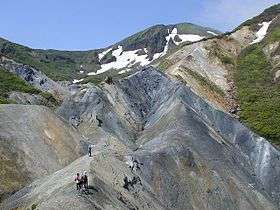
Akita-Komagatake (秋田駒ヶ岳) is an active stratovolcano located 10 km east of Tazawa Lake, near the border between Akita and Iwate prefectures on Honshu Island.[2] The volcano last erupted from 18 September 1970 to 25 January 1971.[3] It is the highest mountain in Akita Prefecture [4] and the second highest in Towada-Hachimantai National Park.[5]
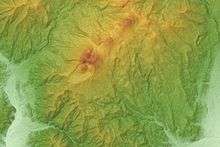
Relief Map
References
- 1 2 "Akita-Komagatake". Global Volcanism Program. Smithsonian Institution. Retrieved 11 August 2014.
- ↑ "Akita-Komaga-take volcano". Volcano Discovery. Retrieved 11 August 2014.
- ↑ "Akita-Komaga-take Volcano — John Seach". Volcano Live. Retrieved 11 August 2014.
- ↑ "Akita Komagatake". Sightseeing spots. Semboku City. Retrieved 11 August 2014.
- ↑ "Mount Akita-Komagatake". Japan Guide. Retrieved 11 August 2014.
External links

- Akita-Komagatake - Japan Meteorological Agency (in Japanese)
- "Akita-Komagatake: National catalogue of the active volcanoes in Japan" (PDF). - Japan Meteorological Agency
- Akita Komagatake - Geological Survey of Japan
- Akita-Komagatake: Global Volcanism Program - Smithsonian Institution
This article is issued from
Wikipedia.
The text is licensed under Creative Commons - Attribution - Sharealike.
Additional terms may apply for the media files.