Causeway Lake, Queensland
| Causeway Lake Queensland | |||||||||||||||
|---|---|---|---|---|---|---|---|---|---|---|---|---|---|---|---|
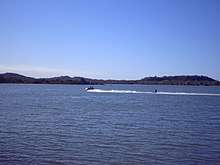
 Looking along Mulambin Beach with Causeway Lake in the background, 2009 | |||||||||||||||
 Causeway Lake | |||||||||||||||
| Coordinates | 23°11′58″S 150°47′46″E / 23.1994°S 150.7961°ECoordinates: 23°11′58″S 150°47′46″E / 23.1994°S 150.7961°E | ||||||||||||||
| Postcode(s) | 4703 | ||||||||||||||
| LGA(s) | Shire of Livingstone | ||||||||||||||
| State electorate(s) | Keppel | ||||||||||||||
| Federal Division(s) | Capricornia | ||||||||||||||
| |||||||||||||||
Causeway Lake is a locality on the Capricorn Coast in the Shire of Livingstone, Queensland, Australia.[1]
Geography
The locality takes its name from the lake of the same name which lies within the locality, both of which take their name from the causeway (and smallbridge) which allows the Scenic Highway to cross the lake's narrow entrance to the Coral Sea.[2]
There is very little development within the locality except for a small residential area on the north-eastern shore of the lake where there is also public parkland access to the lake for recreation. Apart from that, most of the locality is undeveloped being taken up with the lakes and the associated palustrine wetland surrounding the numerous creeks which flow into the lake.[2]
The northern mouth of the lake is part of the Capricorn Coast National Park. The southern part of the locality is within the Causeway Lake Conservation Park.[2]
References
- ↑ "Causeway Lake - locality in Shire of Livingstone (entry 48566)". Queensland Place Names. Queensland Government. Retrieved 9 July 2017.
- 1 2 3 "Queensland Globe". State of Queensland. Retrieved 9 July 2017.
External links
![]()