Salatiga
| Salatiga | ||
|---|---|---|
| City | ||
| Javanese transcription(s) | ||
| • Hanacaraka | ꦯꦭꦠꦶꦒ | |
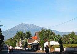 Mount Merbabu viewed from Salatiga. | ||
| ||
| Motto(s): Çrir Astu Swasti Prajabhyah (Be happy, all the People) | ||
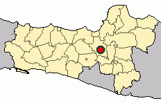 Location within Central Java | ||
| Coordinates: 7°19′29″S 110°32′39.79″E / 7.32472°S 110.5443861°ECoordinates: 7°19′29″S 110°32′39.79″E / 7.32472°S 110.5443861°E | ||
| Country |
| |
| Province |
| |
| Founded | 24 July 750 | |
| Incorporated | 1 July 1917 | |
| Government | ||
| • Mayor | Yulianto | |
| • Vice Mayor | Muh Haris | |
| Area | ||
| • Total | 56.781 km2 (21.923 sq mi) | |
| Elevation[1] | 571 m (1,873 ft) | |
| Population (2015)[2] | ||
| • Total | 183.815 | |
| • Density | 3.2/km2 (8.4/sq mi) | |
| Demographics | ||
| • Ethnic groups |
Javanese | |
| Time zone | UTC+7 (Indonesia Western Standard Time) | |
| Area code | (+62) 298 | |
| Vehicle registration | H | |
| Languages |
Indonesian | |
| Website | www.salatiga.go.id | |


Salatiga (Javanese: ꦯꦭꦠꦶꦒ) is a city in Central Java province, Indonesia. Located between the cities of Semarang and Surakarta, it sits at the foot of Mount Merbabu (3,142 m) and Mount Telomoyo, and has a relatively cool climate due to its elevated position.
Etymology

Salatiga is thought to be named either after the goddess of Trisala, or after the three wrongs done to the first king of Semarang.
In the first explanation, the people of the village celebrate the goddess of Siddhadewi, who is mentioned in the Monolith of Plumpungan. Siddhadewi was also called Trisala, so the village was called Trisala and in the years to come became Salatri and eventually Salatiga.[3]
The second explanation is based on the story of Ki Ageng Pandanaran, the first regent of Semarang, who was robbed by three muggers, and he thus named the location Salah Telu. Salah means wrong in both Indonesian and Javanese. Telu is Low Javanese for three, spelled is tiga in both the more refined Middle/High Javanese (but pronounced /tigo/ in Javanese respectively /tiga/ in Indonesian). Hence the name Salatiga from Salah Tiga.[4]
History
The official birth date of Salatiga is 24 July 750 A.D. (the 31st date and 4th year of the Saka calendar). The scroll Monolith of Plumpungan (Prasasti Plumpungan in Sanskrit) by King Bhanu, declares May you be happy! All the people ("Srir = astu swasti prajabhyah") and designated village of Hampran (Desa Hampran) a Perdikan village (Desa Perdikan, meaning a tax-free village).[5] "Çrirastuswasti Prajabyah" is the official motto of Salatiga as written in the government seal.
In 1746, the Dutch East India Company (Vereenigde Oost-Indische Compagnie, VOC) built De Hersteller fort in Salatiga because Salatiga was strategically located at the intersection between Semarang, Surakarta and Magelang.[6]
On 1 July 1917 the village of Salatiga was designated as a stads gemeente or small town, by the Dutch East Indies government.[7] In the colonial era, Salatiga was stratified by race. The Europeans live near the city centre, at the Toentangscheweg (Toentang Road) because it leads to Semarang and also near to Dutch plantations in the Salatiga Afdeling.[8] The Chinese live near the trading centre, the Kalicacing Market, at the Soloscheweg (Solo Road).[9] The native people live outside the European and Chinese communities.[10] The education system was divided by race, with different schools for the Europeans, the Chinese and the natives.[11] Salatiga was led by a burgermeester (mayor), assisted by College van Burgermeester en Wethouders. There was a legislative body, the Stadsgemeenteraad; however, its membership was not proportional, with 8 seats for the Europeans, 1 seat for the Chinese, and only 2 seats for the natives who form the majority of the people.[12] The birth of Salatiga was accompanied by the world economic depression of the 1930s, so the development of the city was halted, and to solve the increase of the city's spending, the salaries of government officials were cut by up to 15%.[13] Salatiga had an important economic role as a hinterland to Semarang, providing products from coffee, rubber, cacao, cotton, spices, tobacco, wheat and vegetable plantations to Semarang to be processed.[14]
Supported by geographical factors, its cool climate, and its luxurious buildings with Indic architecture,[15] Salatiga's beauty was well-known during the Dutch colonisation, even it was called De Schoonste Stad van Midden-Java (The Most Beautiful City in Central Java).[16]
Administration
Salatiga is divided into four subdistricts (kecamatan): Argomulyo, Tingkir, Sidomukti, and Sidorejo.
| Subdistrict | Area (km2) | Population | Population density (persons/km2) |
|---|---|---|---|
| Argomulyo | 18.526 | 43,424 | 2,344 |
| Tingkir | 10.549 | 42,888 | 4,066 |
| Sidomukti | 11.459 | 41,871 | 3,654 |
| Sidorejo | 16.247 | 55,632 | 3,424 |
| Total | 56.781 | 183,815 | 3,237 |
Bordering Salatiga are the following subdistricts:
- To the North: Pabelan (Pabelan and Pejaten villages) and Tuntang (Kesongo and Watu Agung villages)
- To the South: Getasan (Sumogawe, Samirono and Jetak villages) and Tengaran (Patemon and Karang Duren villages)
- To the East: Pabelan (Ujung-ujung, Sukoharjo and Glawan villages) and Tengaran (Bener, Tegalwaton and Nyamat villages)
- To the West: Tuntang (Candirejo, Jombor, Sraten and Gedangan villages) and Getasan (Polobogo village)
All these districts are located in Semarang Regency, making Salatiga an enclave within Semarang Regency.
Geography
Salatiga is located about 47 km south of Semarang and about 100 km north of Yogyakarta. Its elevation is between 450–800 metres.[18] Salatiga has a tropical monsoon climate (Am) in the Köppen climate classification with the average rainfall of 2,668 mm per year, the highest temperature in October (24.1°C) and the lowest in January (22.4°C).[1]
| Climate data for Salatiga | |||||||||||||
|---|---|---|---|---|---|---|---|---|---|---|---|---|---|
| Month | Jan | Feb | Mar | Apr | May | Jun | Jul | Aug | Sep | Oct | Nov | Dec | Year |
| Average high °C (°F) | 26.4 (79.5) |
26.6 (79.9) |
27.1 (80.8) |
27.7 (81.9) |
27.8 (82) |
28.0 (82.4) |
28.0 (82.4) |
28.7 (83.7) |
29.1 (84.4) |
29.3 (84.7) |
28.0 (82.4) |
27.0 (80.6) |
27.8 (82.1) |
| Daily mean °C (°F) | 22.4 (72.3) |
22.6 (72.7) |
22.9 (73.2) |
23.3 (73.9) |
23.3 (73.9) |
23.0 (73.4) |
22.6 (72.7) |
23.0 (73.4) |
23.5 (74.3) |
24.1 (75.4) |
23.4 (74.1) |
22.7 (72.9) |
23.1 (73.5) |
| Average low °C (°F) | 18.5 (65.3) |
18.6 (65.5) |
18.8 (65.8) |
18.9 (66) |
18.8 (65.8) |
18.0 (64.4) |
17.2 (63) |
17.3 (63.1) |
18.0 (64.4) |
18.9 (66) |
18.8 (65.8) |
18.5 (65.3) |
18.4 (65) |
| Average precipitation mm (inches) | 390 (15.35) |
344 (13.54) |
389 (15.31) |
279 (10.98) |
204 (8.03) |
117 (4.61) |
77 (3.03) |
52 (2.05) |
69 (2.72) |
138 (5.43) |
264 (10.39) |
345 (13.58) |
2,668 (105.02) |
| Source: ClimateData.org[1] | |||||||||||||
Demographics
| Historical population | ||
|---|---|---|
| Year | Pop. | ±% p.a. |
| 1900 | 10,000 | — |
| 1905 | 12,000 | +3.71% |
| 1920 | 18,895 | +3.07% |
| 1929 | 19,192 | +0.17% |
| 1930 | 24,397 | +27.12% |
| 1961 | 58,135 | +2.84% |
| 1971 | 69,184 | +1.76% |
| 2000 | 153,036 | +2.78% |
| 2010 | 171,067 | +1.12% |
| 2015 | 183,815 | +1.45% |
| Source: 1900–1930,[19] 1961–1971,[20] 2000–2010,[21] 2015[2] | ||
As of 2015, Salatiga has a population of 183,815, 89,928 of them are males and 93,887 are females.[2]
Religion
As of 2015, Islam was the most practised religion in Salatiga (78%), followed by Protestantism (16%) and Catholicism (5%). Other religions (Buddhism, Hinduism, Monotheism, Confucianism and aliran kepercayaan) make up less than 1% of the population.[22] Salatiga is repeatedly called "one of the most tolerant cities in Indonesia"[23] and is one of the few cities in Java to hold outdoor Christian festivals during Christmas.[24]
Ethnicity
Salatiga is mainly inhabited by the Javanese, with a sizeable minority of Chinese Indonesians and some Bataks from North Sumatra. As a university town, it also hosts an assembly of other ethnicities from as far as Borneo and New Guinea. In total, there are about 30 ethnicities in Salatiga.[25]
Economy
There is an emerging processing industry that includes textile, tires and animal slaughter in Salatiga. In 2000, this industry contributes 119.76 billion rupiahs to the economy of Salatiga. Salatiga is located at the intersection to and from Semarang, Surakarta and Yogyakarta, benefiting its trade sector. In 2000, the trade sector contributes 109 billion rupiahs to the economy of Salatiga.[18]
Infrastructure
Transport
.jpg)
Salatiga is traversed by provincial road that connects Semarang and Surakarta.[26] Tingkir Terminal is the main bus station in Salatiga, serving intercity buses.[27] The Tamansari Terminal serves angkot (share taxis), even though most of the angkot did not stop at the terminal.[28] The Semarang–Solo Toll Road section Bawen-Salatiga was inaugurated on 25 September 2017.[29] There is a plan to build a junction at Pattimura Street, closer to the city centre than the current junction, to prevent Salatiga from becoming a dead city.[30][31]
Water supply
Clean water is supplied by PDAM Salatiga. The water comes from Kaliombo, Senjoyo, Kali Golek Senjoyo, and Kaligetak water springs.[32]
Education
Tertiary Education
Salatiga has several universities and colleges:[33]
- Satya Wacana Christian University (UKSW), the largest university in Salatiga with 14 Faculties and 3 Doctoral studies, and 14,000 students and 300 faculty members. It was founded in 1956.[34]
- Institut Agama Islam Negeri Salatiga (IAIN Salatiga), an Islamic college specialising in Education[35]
- Sekolah Tinggi Ilmu Ekonomi (STIE AMA), a private college specialising in Economics
Schools
There are 96 elementary schools,[36] 27 junior high schools,[37] 33 senior high schools,[38] and 19 vocational schools[38] in Salatiga. Schools in Salatiga are normally affiliated with the government, universities, or religious institutions. In the past, state-run schools are generally sought after for their quality and subsidised cost however this had changed significantly. Students also generally compete by using final examination grades and written examinations to enter the more popular schools.
Salatiga has one international English-speaking school at elementary and secondary level (Mountainview International Christian School).
Gallery
 Church in Salatiga
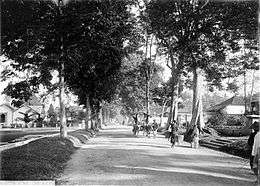
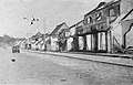 Salatiga during the National Revolution Era.
References
- 1 2 3 "Climate: Salatiga". ClimateData.org. Archived from the original on 18 January 2018. Retrieved 31 January 2017.
- 1 2 3 "Salatiga Municipality Population by Age Group and Sex, 2015". Badan Pusat Statistik Kota Salatiga. Archived from the original on 30 March 2017. Retrieved 30 March 2017.
- ↑ Maharani 2009, p. 37.
- ↑ Maharani 2009, p. 38.
- ↑ Mubarok, Imam (30 August 2014). "Menengok Prasasti Plumpungan, cikal bakal Salatiga". Merdeka.com. Archived from the original on 28 December 2016. Retrieved 28 December 2016.
- ↑ Maharani 2009, p. 63.
- ↑ Maharani 2009, p. 42.
- ↑ Maharani 2009, pp. 48–49.
- ↑ Maharani 2009, p. 52.
- ↑ Maharani 2009, p. 54.
- ↑ Maharani 2009, p. 49.
- ↑ Maharani 2009, p. 56.
- ↑ Maharani 2009, p. 59.
- ↑ Maharani 2009, p. 64.
- ↑ Maharani 2009, p. 57.
- ↑ "Sejarah Kota Salatiga" [History of the City of Salatiga] (in Indonesian). Government of the City of Salatiga. Archived from the original on 19 August 2006.
- ↑ Statistics of Salatiga Municipality 2016, p. 49.
- 1 2 "Kota Salatiga". Kompas (in Indonesian). 13 February 2002. Archived from the original on 14 February 2002.
- ↑ Maharani 2009, p. 45.
- ↑ Laporan Hasil Sementara Sensus Penduduk 1971 Djawa Tengah (PDF). Badan Pusat Statistik. 1971. p. 15. Archived from the original (PDF) on 4 April 2017. Retrieved 3 April 2017.
- ↑ "Salatiga Harus Tekan Pertumbuhan Penduduk" [Salatiga Must Suppress Population Growth]. Kompas (in Indonesian). 1 December 2010. Archived from the original on 4 April 2017. Retrieved 3 April 2017.
- ↑ Statistics of Salatiga Municipality 2016, pp. 110–111.
- ↑ Munir, Syahrul (20 November 2017). "Salatiga Kembali Raih Predikat Kota Paling Toleran di Indonesia". KOMPAS.com (in Indonesian). Archived from the original on 1 December 2017. Retrieved 28 November 2017.
- ↑ Seo, Myengkyo (2013). State Management of Religion in Indonesia. Routledge. p. 107. ISBN 978-0-415-51716-4. Archived from the original on 16 September 2017.
- ↑ Munir, Syahrul (24 February 2018). "Indonesia Mini di "Kampus Toleransi" Salatiga". Kompas. Retrieved 13 September 2018.
- ↑ Surtiani 2006, p. 88.
- ↑ Kundori, Moch (26 May 2016). "Dishub Razia Kelaikan Bus Jelang Angkutan Lebaran". Suara Merdeka (in Indonesian). Archived from the original on 26 March 2017. Retrieved 26 March 2017.
- ↑ Surya Yuli P (2 February 2017). "Pembangunan Terminal Tamansari Sudah Mendesak". Suara Merdeka (in Indonesian). Archived from the original on 2 February 2017. Retrieved 26 March 2017.
- ↑ Wisnu Adhi N (25 September 2017). "Jalan tol Bawen-Salatiga diresmikan, hujan mengguyur" (in Indonesian). Antara. Archived from the original on 7 November 2017. Retrieved 1 November 2017.
- ↑ Munir, Syahrul (8 June 2017). "Soal Keindahan "View" Gerbang Tol Salatiga, Ketua DPRD Sebut Tak Penting". Kompas (in Indonesian). Archived from the original on 8 July 2017. Retrieved 1 November 2017.
- ↑ Setiawan, Deni (22 September 2017). "Usulan Penambahan Exit Tol di Jalan Pattimura Salatiga Disetujui". Tribun Jateng (in Indonesian). Retrieved 1 November 2017.
- ↑ Surtiani 2006, p. 89.
- ↑ Statistics of Salatiga Municipality 2016, pp. 88–90.
- ↑ Michaella, Sonya (28 December 2015). "Toleransi Agama, Tirulah Salatiga". telusur.metrotvnews.com. Archived from the original on 13 April 2017. Retrieved 13 April 2017.
- ↑ "IAIN Salatiga – Institut Agama Islam Negeri Salatiga". Institut Agama Islam Negeri Salatiga. Retrieved 6 November 2017.
- ↑ Statistics of Salatiga Municipality 2016, p. 81.
- ↑ Statistics of Salatiga Municipality 2016, p. 83.
- 1 2 Statistics of Salatiga Municipality 2016, p. 86.
Works cited
- Maharani, Lutvia (2009). Pengambilalihan Kota Salatiga dari Kekuasaan Belanda ke Pemerintah Republik Indonesia Tahun 1945-1950 [Takeover of Salatiga City from the Dutch to the Government of the Republic of Indonesia in 1945-1950] (PDF) (Thesis) (in Indonesian). State University of Semarang. Archived (PDF) from the original on 28 December 2016. Retrieved 28 December 2016.
- Statistics of Salatiga Municipality (2016). Kota Salatiga dalam Angka 2016 [Salatiga Municipality in Figures 2016] (PDF) (in Indonesian). Statistics of Salatiga Municipality. ISSN 2355-3065. Archived from the original (PDF) on 4 April 2017. Retrieved 3 April 2017.
- Surtiani, Eny Endang (2006). Faktor-Faktor yang Mempengaruhi Terciptanya Kawasan Permukiman Kumuh di Kawasan Pusat Kota (Studi Kasus: Kawasan Pancuran, Salatiga) [Factors that Influence the Formation of Slum in the City Centre (Case Study: Pancuran Region, Salatiga)] (PDF) (Thesis) (in Indonesian). Diponegoro University. Archived (PDF) from the original on 15 February 2017. Retrieved 9 November 2017.
External links


- (in Indonesian) Official website

- Salatiga historical photo archives
Regencies and cities of Central Java | ||
|---|---|---|
Capital: Semarang | ||
| Regencies |  | |
| Cities | ||