Tobago
| Tobago | |||
|---|---|---|---|
| Autonomous Island | |||
| |||
|
Motto(s): "Pulchrior Evenit" (Latin) "She becomes more beautiful" | |||
| Anthem: Forged From The Love of Liberty | |||
 Map of Tobago (large island), Little Tobago (far right) Goat Island (between Tobago and Little Tobago) & St. Giles Island (top right). | |||
| Coordinates: 11°15′00″N 60°40′01″W / 11.250°N 60.667°WCoordinates: 11°15′00″N 60°40′01″W / 11.250°N 60.667°W | |||
| Country |
| ||
| Capital and largest city | Scarborough | ||
| Government | |||
| • President of Trinidad and Tobago | Paula-Mae Weekes | ||
| • Prime Minister of Trinidad and Tobago | Keith Rowley | ||
| • Chief Secretary of Tobago | Kelvin Charles | ||
| • Legislature | Tobago House of Assembly (Unicameral) | ||
| Area[1] | |||
| • Total | 300 km2 (116 sq mi) | ||
| Population (2011)[1] | |||
| • Total | 60,874 | ||
| • Density | 203/km2 (530/sq mi) | ||
| Time zone | UTC-4 (AST) | ||
| Postal Code | 90xxxx - 98xxxx [2] | ||
| Calling code | +1 (868) | ||
| Official language(s) | English | ||
| Currency | Trinidad and Tobago dollar (TTD) | ||
| TLD | .tt | ||
Tobago (/təˈbeɪɡoʊ/) is an autonomous island within the Republic of Trinidad and Tobago. It is located 35 kilometres (22 mi) northeast of the mainland of Trinidad and southeast of Grenada, about 160 kilometres (99 mi) off the coast of northeast Venezuela. According to the earliest English-language source cited in the Oxford English Dictionary, Tobago bore a name that has become the English word tobacco. The national bird of Tobago is the cocrico.
History
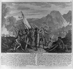
Christopher Columbus first sighted Tobago in 1498. Subsequently, several powers fought over possession of the island.[3]
The original Island Carib population had to defend the island against other Amerindian tribes. Then, during the late 1500s and early 1600s, the natives defended it from European colonists, including 1654, including an attempt by the Courlanders, who colonised the island intermittently between 1637-1690. Over the ensuing years, the Curonians (Duchy of Courland), Dutch, English, French, Spanish and Swedish had caused Tobago to become a focal point in repeated attempts of colonisation, which led to the island having changed hands 33 times, the most in Caribbean history, before the Treaty of Paris ceded it to the British in 1814. In 1662, the Dutch brothers Adrian and Cornelius Lampsins were granted the title of Barons of Tobago, and ruled until the English captured the island in 1666. Adrian briefly recaptured Tobago in 1673, but was killed in battle when the English, under Sir Tobias Bridge yet again took control of the island.[4]
From about 1672, during the temporary British rule of 1672-1674,[5] Tobago had a period of stability during which plantation culture began. Sugar, cotton and indigo factories sprang up and Africans were imported by the British to work as slaves. The economy flourished. France had abandoned the island to Britain in 1763,[6] and by 1777 Tobago was exporting great quantities of cotton, indigo, rum and sugar. But in 1781, the French re-invaded Tobago, and destroyed the plantations, and forced the British governor to surrender. The island's buoyant economy fell into decline.
In 1814, when the island again came under British control, another phase of successful sugar-production began. But a severe hurricane in 1847, combined with the collapse of plantation underwriters, marked the end of the sugar trade. In 1889 the island became a ward of Trinidad. Without sugar, the islanders had to grow other crops, planting acres of limes, coconuts and cocoa and exporting their produce to Trinidad. In 1963 Hurricane Flora ravaged Tobago, destroying the villages and crops. A restructuring programme followed and attempts were made to diversify the economy. The development of a tourist industry began.
Trinidad and Tobago obtained its independence from the British Empire in 1962 and became a republic in 1976.
Demographics
The population was 60,874 at the 2011 census.[1] The capital, Scarborough, has a population of 17,537. While Trinidad is multiethnic, Tobago's population is primarily of African descent, although with a growing proportion of Trinidadians of East Indian descent and Europeans. Between 2000 and 2011, the population of Tobago grew by 12.55 percent, making it one of the fastest-growing areas of Trinidad and Tobago.
Ancestry
| Racial composition | 2011[7] |
|---|---|
| Dark Skin (Afro-Trinidadian/Tobagonian) | 85.2% |
| Dougla (South Asian and Black) | 4.2% |
| Multiracial | 4.2% |
| South Asian (Indo-Trinidadian) | 2.5% |
| White Trinidadian/Tobagonian | 0.7% |
| Native American (Amerindian) | 0.1% |
| East Asian (Chinese) | 0.08% |
| Arab (Syrian/Lebanese) | 0.02% |
| Other | 0.1% |
| Not stated | 2.6% |
Government
Local Government and Central Government functions in Tobago are handled by the Tobago House of Assembly. The current Chief Secretary of the THA is Kelvin Charles. The People's National Movement controls 10 of the 12 seats in the Assembly, with the Progressive Democratic Patriots led by union leader Watson Duke controlling two seats since the 23 January 2017 election.[8]
Tobago has two parliamentary seats, Tobago East and Tobago West, which are controlled by the People's National Movement, which won them in the general elections of Trinidad and Tobago on 7 September 2015. The island was most recently featured in the international press in early 2007, for its establishment of a Minister of Mental Health. Minister Ellen Tang was appointed on the first anniversary of the launch of the Happiness Project. Her aide, Melody Williams, has been allocated a major proportion of the annual housing funding to revamp government housing projects all over the island.
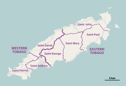
Parishes
Tobago is divided into seven parishes – three in the Western Region and four in the Eastern Region:
| Region | Parish name | Land area (km2)[1] | Population[1] |
|---|---|---|---|
| Western | Saint Andrew | 21 | 17,536 |
| Western | Saint Patrick | 38 | 15,560 |
| Western | Saint David | 38 | 8,733 |
| Eastern | Saint George | 43 | 6,875 |
| Eastern | Saint Mary | 56 | 3,297 |
| Eastern | Saint Paul | 49 | 6,048 |
| Eastern | Saint John | 55 | 2,825 |
Geography
.jpg)
Tobago has a land area of 300 km²[1] and is approximately 40 kilometres (25 miles) long and 10 kilometres (6.2 miles) wide. It is located at latitude 11° 15' N, longitude 60° 40' W, slightly north of Trinidad.
Tobago is primarily hilly, mountainous and of volcanic origin.[9] The southwest of the island is flat and consists largely of coralline limestone. The hilly spine of the island is called the Main Ridge. The highest point in Tobago is the 550-metre (1804 ft) Pigeon Peak near Speyside.[10]
Climate
The climate is tropical, and the island lies just south of the Atlantic hurricane belt, making it vulnerable to occasional southward-travelling tropical storms. Average rainfall varies between 3,800 mm (150 inches) on the Main Ridge to less than 1,250 mm (49 inches) in the southwest. There are two seasons: a wet season between June and December, and a dry season between January and May.[11]
Hurricanes
Due to its close proximity to the hurricane belt, the island was struck by Hurricane Flora on September 30, 1963. The effects were so severe that they changed the face of Tobago's economy. The hurricane laid waste to the banana, coconut, and cacao plantations that largely sustained the economy, and wreaked considerable damage on the largely pristine tropical rainforest that makes up a large proportion of the interior of the island's northern half. Many of the plantations were subsequently abandoned, and the economy changed direction away from cash crop agriculture and toward tourism. In 2004 Hurricane Ivan, while less severe than Flora, also caused significant damage.
Ecology
The Tobago Forest Reserve (Main Ridge Reserve) is the oldest protected rain forest in the Western hemisphere and is biodiverse. It was designated a protected Crown reserve on 17 April 1776 after representations by Soame Jenyns, a Member of Parliament in Britain responsible for Tobago's development. It has remained a protected area since.
This forested area has great biodiversity, including many species of birds (such as the dancing blue-backed manakin), mammals, frogs, (non-venomous) snakes, butterflies and other invertebrates. It is one of the most approachable areas of rainforest, since it is relatively small and there are government-appointed guides who provide an authoritative guiding service through the forest at a reasonable cost. The guides are knowledgeable about the plants and the animals, and can call down rare and exotic birds from the canopy by imitating their calls. Tobago also has nesting beaches for the leatherback turtle, which come to shore between April and July.
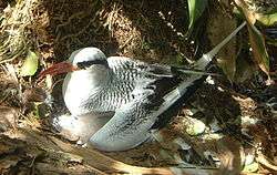
Little Tobago, the small neighbouring island, supports some of the best dry forest remaining in Tobago. Little Tobago and St. Giles Island are important seabird nesting colonies, with red-billed tropicbirds, magnificent frigatebirds and Audubon's shearwaters, among others.
Environmental problems
Coral reefs have been damaged recently by silt and mud runoff during construction of a road along the northeast coast. There has also been damage to the reef in Charlotteville village caused by sealing the road at Flagstaff Hill and diverting more silty water down the stream from Flagstaff down to Charlotteville.
Economy and tourism
.JPG)
.JPG)
.JPG)
.JPG)
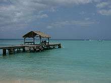
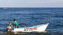
Tobago's main economy is based on tourism, fishing, and government spending, government spending being the largest. Tourism is still a fledgling industry and needs to be developed. The local governing body, The Tobago House of Assembly (THA), employs 62% of the labor force.
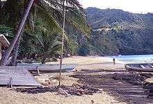
Tobago's economy is tightly linked with Trinidad which is based on liquefied natural gas (LNG), petrochemicals, and steel. The principal economic forces specific to Tobago are tourism and government spending. Conventional beach and water-sports tourism is largely in the southwest around the airport and the coastal strip. Meanwhile, ecotourism is growing in significance, much of it focused on the large area of protected forest in the centre and north of the main island and on Little Tobago, a small island off the main island's northeast tip.
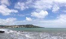
The southwestern tourist area around Crown Point, Store Bay, Buccoo Reef, and Pigeon Point has large expanses of sand and is dominated by resort-type developments. Tobago has many idyllic beaches along its coastline, especially those at Castara, Bloody Bay, and Englishman's Bay. Tobago is linked to the world through the Arthur Napoleon Raymond Robinson International Airport (formerly Crown Point Airport) and Scarborough harbour. Domestic flights connect Tobago with Trinidad, and international flights connect with the Caribbean and Europe. There is a daily fast ferry service between Port of Spain and Scarborough.
Tobago was thought by some to have been the island that inspired Robinson Crusoe,[12][13] but the book is probably based on some of the experiences of Alexander Selkirk, who was marooned in the Pacific's Juan Fernández Islands. Adding to the confusion, Tobago was the filming location for the Walt Disney movie Swiss Family Robinson in 1959.
Swiss Family Robinson
In 1958, Tobago was chosen by the Walt Disney Company as the setting for a film based upon the Johann Wyss novel, Swiss Family Robinson. When producers saw the island for the first time, they "fell instantly in love".[14] [15] The script required animals, who arrived from all around the world, including 8 dogs, 2 giant tortoises, 40 monkeys, 2 elephants, 6 ostriches, 4 zebras, 100 flamingos, 6 hyenas, 2 anacondas, and a tiger.[14]
Filming locations include; Richmond Bay (the Robinsons beach), Mount Irvine Bay (the Pirates beach), and the Craig Hall Waterfalls. The infamous treehouse was constructed in a 200-foot tall saman in the Goldsborough Bay area. After filming, locals convinced Disney, who had intended to remove all evidence of filmmaking, to let the treehouse remain, sans interior furnishing. In 1960, the treehouse was listed for sale for $9,000, a fraction of its original cost, and became a popular attraction before the structure was destroyed by Hurricane Flora in 1963.[16] The tree still remains, however, and is located on the property of the Roberts Auto Service and Tyre Shop, located in Goldsborough, just off of Windward Road. A local Tobago resident says, "The tree has fallen into obscurity; only a few of the older people knew of its significance. As a matter of fact, not many people know of the film Swiss Family Robinson, much less that it was filmed here in Tobago."[17]
Diving
Tobago is also a popular diving location, since it is the southernmost of the Caribbean islands that have coral communities. Trinidad, which is further south, has no significant coral because of low salinity and high silt content, the result of its position close to the mouth of Venezuela's Orinoco River. Scuba diving on Tobago tends to be centred at Speyside, almost diametrically across the island from the airport.
The island has some of the best diving sites in the Caribbean. There are three wrecks located around its shores, but the one usually considered the best is the Maverick Ferry, which used to travel between Trinidad and Tobago. The ferry is 350 feet (110 metres) long and has been sunk in 30 metres (98 feet) just off Rocky Point, Mt. Irvine. The top of the wreck is at 15 metres (49 feet). The wreck has an abundance of marine life, including a 4-foot (1.2-metre) jewfish, a member of the grouper family. The wreck was purposely sunk for divers, and so all the doors and windows were removed. The waters around the island are home to many species of tropical fish, rays, sharks, and turtles.[18]
Golf
Tobago is home to two golf courses, both of which are open to visitors. The older of the two is Mount Irvine Hotel Golf Course, built in 1968. It was seen throughout the world after hosting the popular golf show "Shell's Wonderful World of Golf". The course is built amongst coconut palms and has a view of the Caribbean Sea from almost every hole. Formerly known as Tobago Plantations Golf Course, the recently renamed Magdalena Grand Hotel & Golf Club was opened in 2001 and has hosted the European Seniors Tour on three occasions.
Notable Tobagonians
- Calypso Rose, singer
- Winston Duke, actor
- Lalonde Gordon, Olympic athlete
- Mighty Shadow, singer
- Keith Rowley, politician
- A. N. R. Robinson, politician
- Dwight Yorke, footballer
See also
References
- 1 2 3 4 5 6 Trinidad and Tobago 2011 Population and Housing Census Demographic Report (PDF) (Report). Trinidad and Tobago Central Statistical Office. p. 26. Retrieved 27 May 2016.
- ↑ "List of Postal Districts". TTPOST. TTPOST. July 29, 2018. Retrieved July 29, 2018.
- ↑ "Railroad Map of Trinidad". World Digital Library. 1925. Retrieved 2013-10-25.
- ↑ Riddell (Author), Henri de Bourbon (comte de Chambord.) , John. “The Patent of Baron to C Van Lampsins.” The Pedigree of the Duchess of Mantua, Montferrat and Ferrara, Oxford University, 1885, pp. 8–10.
- ↑
Nimblett, Lennie M. (2012). Tobago: The Union with Trinidad 1889-1899. AuthorHouse. pp. 11–12. ISBN 9781477234501. Retrieved 2015-02-05.
1672: England declared war against the Netherlands and captured Tobago.
1673: The Dutch defeated the English in the third Anglo/Dutch war and occupied Tobago in May 1674 after the Peace of Westminster. - ↑
Nimblett, Lennie M. (2012). Tobago: The Union with Trinidad 1889-1899. AuthorHouse. p. 12. ISBN 9781477234501. Retrieved 2015-02-05.
The island remained in dispute between Britain and France and was essentially a neutral island between 1679 and 1763. [...] Tobago [was] formally ceded by France to Britain at the Treaty of Paris 1763 after the Seven Years War.
- ↑ Central Statistical Office. "NON-INSTITUTIONAL POPULATION BY SEX, AGE GROUP, ETHNIC GROUP AND MUNICIPALITY" (PDF).
- ↑ Staff (2009-01-22). "TOP gains ground, but unhappy with illegal advertising". Trinidad and Tobago Guardian. Retrieved 2009-04-10.
- ↑ "Tobago (Great Tobago) [1551]". United Nations Earthwatch. Retrieved 2011-10-19.
- ↑ Anthony, Michael (2001). Historical Dictionary of Trinidad and Tobago. Scarecrow Press, Inc. Lanham, Maryland, and London, UK. ISBN 0-8108-3173-2.
- ↑ "Climate | Trinidad & Tobago Meteorological Service". www.metoffice.gov.tt. Retrieved 2017-02-02.
- ↑ Rhead, Louis. LETTER TO THE EDITOR: "Tobago Robinson Crusoe's Island", The New York Times, 5 August 1899.
- ↑ "Robinson Crusoe and Tobago", Island Guide
- 1 2 Passafiume, Andrea. "SWISS FAMILY ROBINSON (1960)". Turner Classic Movies. Retrieved 9 April 2013.
- ↑ Maltin 1995, p. 176.
- ↑ "Some Really, Really Big Roots". Kevin Kidney. Retrieved 6 January 2015.
- ↑ "Swiss Family Tree Found". Kevin Kidney. Retrieved 2015-01-06.
- ↑ https://www.theguardian.com/discover-tobago/2016/apr/15/tobagos-spectacular-dive-sites
External links
| Wikimedia Commons has media related to Tobago. |
| Look up tobago in Wiktionary, the free dictionary. |
| Wikivoyage has a travel guide for Tobago. |
- Tobago Hotel & Tourism Association
- Tobago House of Assembly
- Tobago at worldstatesmen.org.
- Government of the Republic of Trinidad and Tobago
- Parishes of Tobago (map)
- Definitive Tourist Guide to Tobago

| Major Islands | ||
|---|---|---|
| Bocas Islands | ||
| The Five Islands | ||
| San Diego Islands | ||
| Islands off Tobago |
| |
| Other Islands | ||