Demerara
| Colony of Demerara Kolonie Demerary | |||||||||
|---|---|---|---|---|---|---|---|---|---|
| 1745–1815 | |||||||||
 Flag
 Coat of arms
| |||||||||
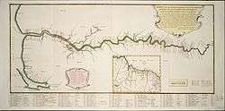 The Demerara colony in 1759 (Note this map has East at its top.) See here for its exact location (6° 48' N 58° 10' W). | |||||||||
| Status | Dutch colony | ||||||||
| Capital | Stabroek | ||||||||
| Common languages | Dutch | ||||||||
| History | |||||||||
• Established | 1745 | ||||||||
• Ceded to the United Kingdom | November 20 1815 | ||||||||
| |||||||||
Part of a series on the |
||||||||||||||
|---|---|---|---|---|---|---|---|---|---|---|---|---|---|---|
| History of Guyana | ||||||||||||||
 | ||||||||||||||
|
||||||||||||||
|
| ||||||||||||||
(1830s).jpg)
Demerara (Dutch: Demerary) is a historical region in the Guianas on the north coast of South America which is now part of the country of Guyana. It was a Dutch colony until 1815 and a county of British Guiana from 1838 to 1966. It was located about the lower courses of the Demerara River, and its main town was Georgetown.
The name "Demerara" comes from a variant of the Arawak word "Immenary" or "Dumaruni" which means "river of the letter wood".[1] Demerara sugar is so named because originally it came from sugar cane fields in the colony of Demerara.
History
In 1745, Demerara was separated from Essequibo.
In 1781, the American revolution induced the Dutch Republic to join with the Bourbon side against the British, a large fleet under Admiral Lord Rodney's command was sent to the West Indies, and after having made some seizures in the Caribbean Islands, a squadron was detached to take possession of the colonies of Essequebo and Demerara, which was accomplished without much difficulty.[2] In 1782 the French took possession of the whole of the Dutch settlements, compelling Gov. Robert Kingston to surrender.[3] The peace of Paris, which occurred in 1783, restored these territories to the Dutch.
The British recaptured Demerara, Essequibo, and Berbice in 1796. They returned the colony to the Dutch in 1802 under the terms of the Peace of Amiens, but re-took control of it a year later.
On 13 August 1814, the British combined the colonies of Demerara and Essequibo into the colony of Demerara-Essequibo. On 20 November 1815, the Netherlands formally ceded the colony to Britain.
Large slave rebellions broke out in West Demerara in 1795 and on the East Coast of Demerara in 1823.[4] Although these rebellions were easily and bloodily crushed, according to Winston McGowan, they may have had a long-term impact in ending slavery:
The 1823 revolt had a special significance not matched by the earlier Berbice uprising. It attracted attention in Britain inside and outside Parliament to the terrible evil slavery and the need to abolish it. This played a part, along with other humanitarian, political and economic factors, in causing the British parliament ten years later in 1833 to take the momentous decision to abolish slavery in British Guiana and elsewhere in the British Empire with effect from 1 August 1834. After serving four years of a modified form of slavery euphemistically called apprenticeship, the slaves were finally freed on 1 August 1838.
— [5]
On 21 July 1831, Demerara-Essequibo united with Berbice as British Guiana, now Guyana. In 1838, Demerara was made one of the three counties of Guiana, the other two being Berbice and Essequibo.[6] In 1958, the county was abolished when Guiana was subdivided into districts. Currently, historical Demerara is part of (and the name is used in) the Guyanese administrative regions of Demerara-Mahaica, Essequibo Islands-West Demerara, and Upper Demerara-Berbice.[6]
Notable Demerarans
- Sir James Douglas, Governor of the Colony of Vancouver Island (1851–64) and the Colony of British Columbia (1858–64).
- Rev. Joseph Ketley, Congregational missionary, mid 19th century.
- John Edmonstone, a freed slave who taught Charles Darwin taxidermy.
Commanders of Demerara
- Jonathan Samuel Storm van 's Gravesende (†1761) (1752–1761)
- Laurens Lodewijk van Bercheijk (†1765) (1761–1765)
- Jan Cornelis van den Heuvel (1765–1770)
- Paulus van Schuylenburgh (1772–1781)
- Antony Beaujon (22 April 1796 – 27 March 1802)
Governors of Demerara
- Robert Kingston (27 February 1781 – 1782)
- Louis Antoine Dazemard de Lusignan (1782)
- Armand Guy Simon de Coëtnempren, comte de Kersaint (*1742 – †1793) (1782)
- Georges Manganon de la Perrière (1783–1784)
Directors-general
- Joseph Bourda (acting) (6 March 1784 – February 1785)
- Jan L'Éspinasse (February 1785 – 18 August 1789)
- Albertus Backer (18 August 1789 – 31 March 1793)
- Willem August van Sirtema, baron van Grovestins (31 March 1793 – May 1795)
- Antony Beaujon (*17... – †1805) (1795 – 22 April 1796)
- Antony Meertens (27 March 1802 – September 1803)
Lieutenant governors
- Robert Nicholson (September 1803 – 18 August 1804)
- Antony Beaujon (18 August 1804 – 19 October 1805)
- James Montgomery (acting) (19 October 1805 – 8 May 1806)
- Count Henri Guillaume (Henry William) Bentinck (*1765 – †1821) (8 May 1806 – February 1812)
- Hugh Lyle Carmichael (*1764 – †1813) (February 1812 – 11 May 1813)
- E. Codd (acting) (11 May 1813 – 23 May 1813)
- John Murray (23 May 1813 – 26 April 1824)
- Sir Benjamin d'Urban (26 April 1824 – 21 July 1831)
Sportspeople
- Clive Lloyd – Most successful Captain West Indies cricket team
- Shivnarine Chanderpaul – Member of the West Indies cricket team and former captain
- Roger Harper – Former member of the West Indies cricket team
- Carl Hooper – Former member of the West Indies cricket team
- Lance Gibbs – Former member of the West Indies cricket team
- Colin Croft – Former member of the West Indies cricket team
- Andrew Watson – Footballer
- Julian Austin – Represented Canada in World Cup of Hockey 1978, Pan American Games 79&83 Silver&Gold Medal Also a member of the 1984 Olympic Team (Retired)
Leaders of rebellions
- 1823: Jack Gladstone of Plantation Success
- 1823: Quamina of Plantation Success
See also
References
- ↑ Benn, Brindley H. (1962-06-30). "Guyana the Name". Thunder. Georgetown, Guyana. Archived from the original on May 1, 2008.
- ↑ Hadden p.64
- ↑ Dalton p.239
- ↑ McGowan, Winston (2000). "The distinctive features of the 1823 Demerara slave rebellion". Starbroeck News. Retrieved 2017-08-15.
- ↑ McGowan, Winston (2006). "The 1763 and 1823 slave rebellions (Part 2)". Stabroek News. Archived from the original on 2007-09-27. Retrieved 2006-12-07.
- 1 2 Regions of Guyana at Statoids.com. Updated 20 June 2011. Retrieved 20 March 2013.
Further reading
- da Costa, Emilia Viotti. Crowns of Glory, Tears of Blood (1994). scholarly study of the Demerara slave rebellion of 1823.
- Oostindie, Gert. "‘British Capital, Industry and Perseverance’ versus Dutch ‘Old School’? The Dutch Atlantic and the Takeover of Berbice, Demerara and Essequibo, 1750-1815" BMGN: Low Countries Historical Review (2012) 127#4 pp 28-55.
- St Pierre, Maurice. "The 1823 Guyana Slave Rebellion: A Collective Action Reconsideration." Journal of Caribbean History 41#1/2 (2007): 142.
- Sheridan, Richard B. "The condition of the slaves on the sugar plantations of Sir John Gladstone in the colony of Demerara, 1812-49." New West Indian Guide/Nieuwe West-Indische Gids 76#3-4 (2002): 243-269.