Manistique, Michigan
| City of Manistique, Michigan | |
|---|---|
| City | |
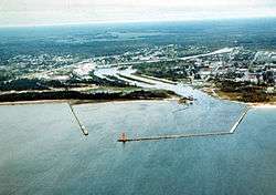 Aerial view of Manistique. The Manistique River flows into Lake Michigan through the center of the city | |
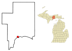 Location of Manistique, Michigan | |
| Coordinates: 45°57′28″N 86°14′59″W / 45.95778°N 86.24972°WCoordinates: 45°57′28″N 86°14′59″W / 45.95778°N 86.24972°W | |
| Country | United States |
| State | Michigan |
| County | Schoolcraft |
| Area[1] | |
| • Total | 3.51 sq mi (9.09 km2) |
| • Land | 3.19 sq mi (8.26 km2) |
| • Water | 0.32 sq mi (0.83 km2) |
| Elevation | 600 ft (183 m) |
| Population (2010)[2] | |
| • Total | 3,097 |
| • Estimate (2016)[3] | 2,918 |
| • Density | 880/sq mi (340/km2) |
| Time zone | UTC-5 (Eastern (EST)) |
| • Summer (DST) | UTC-4 (EDT) |
| ZIP code | 49854 |
| Area code(s) | 906 |
| FIPS code | 26-50760[4] |
| GNIS feature ID | 1620685[5] |
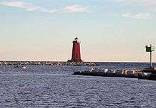
Manistique, formerly Monistique,[6] is the only incorporated city in and the county seat of Schoolcraft County[7] of the U.S. state of Michigan's Upper Peninsula. As of the 2010 census, the city population was 3,097. The city lies on the north shore of Lake Michigan, adjacent the southwest corner of Manistique Township. Manistique was founded where the Manistique River flows into Lake Michigan, forming a kind of natural harbor, which has since been improved with breakwaters, dredging, and a lighthouse. The city takes its name from the Manistique River.[8] The economy also depends heavily on tourism.
History
.jpg)
Originally named Eastport, Manistique replaced Onota as the county seat.[9] Eppsport was the name of the post office, but was not used for the community.[6] Manistique was incorporated as a village in 1883[6] and as a city in 1901 by the state legislature. With the river originally spelled Monistique, a spelling error in the city charter led to its current spelling.[8]
Nickname
Manistique is nicknamed "The Emerald City." It is believed to be named for the emerald green waters of the nearby Kitch-iti-kipi spring, the largest spring in the state of Michigan. The Manistique Area Schools athletic teams are referred to as the "Emeralds." Several local businesses include "Emerald City" in their names.
Geography
According to the United States Census Bureau, the city has a total area of 3.51 square miles (9.09 km2), of which 3.19 square miles (8.26 km2) is land and 0.32 square miles (0.83 km2) is water.[1]
Climate
This climatic region is typified by large seasonal temperature differences, with warm to hot (and often humid) summers and cold (sometimes severely cold) winters. According to the Köppen Climate Classification system, Manistique has a humid continental climate, abbreviated "Dfb" on climate maps.[10]
Demographics
| Historical population | |||
|---|---|---|---|
| Census | Pop. | %± | |
| 1880 | 693 | — | |
| 1890 | 2,940 | 324.2% | |
| 1900 | 4,126 | 40.3% | |
| 1910 | 4,722 | 14.4% | |
| 1920 | 6,380 | 35.1% | |
| 1930 | 5,198 | −18.5% | |
| 1940 | 5,399 | 3.9% | |
| 1950 | 5,086 | −5.8% | |
| 1960 | 4,875 | −4.1% | |
| 1970 | 4,324 | −11.3% | |
| 1980 | 3,962 | −8.4% | |
| 1990 | 3,456 | −12.8% | |
| 2000 | 3,583 | 3.7% | |
| 2010 | 3,097 | −13.6% | |
| Est. 2016 | 2,918 | [3] | −5.8% |
| Source: Census Bureau. Census 1880, 1970, 1980, 1990, 2000, 2010. | |||
2010 census
As of the census[2] of 2010, there were 3,097 people, 1,383 households, and 765 families residing in the city. The population density was 970.8 inhabitants per square mile (374.8/km2). There were 1,617 housing units at an average density of 506.9 per square mile (195.7/km2). The racial makeup of the city was 86.0% White, 0.2% African American, 9.7% Native American, 0.2% Asian, 0.1% from other races, and 3.9% from two or more races. Hispanic or Latino of any race were 1.0% of the population.
There were 1,383 households of which 27.9% had children under the age of 18 living with them, 37.5% were married couples living together, 12.6% had a female householder with no husband present, 5.3% had a male householder with no wife present, and 44.7% were non-families. 40.3% of all households were made up of individuals and 20.3% had someone living alone who was 65 years of age or older. The average household size was 2.15 and the average family size was 2.87.
The median age in the city was 43 years. 23% of residents were under the age of 18; 7.3% were between the ages of 18 and 24; 22.4% were from 25 to 44; 26.6% were from 45 to 64; and 20.6% were 65 years of age or older. The gender makeup of the city was 46.3% male and 53.7% female.
Intrastructure
Transportation


- Indian Trails provides daily intercity bus service between St. Ignace and Ironwood, Michigan.[11]
- Manistique is serviced by the Schoolcraft County Airport (KISQ)
References
- 1 2 "US Gazetteer files 2010". United States Census Bureau. Archived from the original on 2012-01-24. Retrieved 2012-11-25.
- 1 2 "American FactFinder". United States Census Bureau. Retrieved 2012-11-25.
- 1 2 "Population and Housing Unit Estimates". Retrieved June 9, 2017.
- ↑ "American FactFinder". United States Census Bureau. Retrieved 2008-01-31.
- ↑ U.S. Geological Survey Geographic Names Information System: Manistique, Michigan
- 1 2 3 "Mrs. Mutart Longest Manistique Resident; Here 60 Yrs. Monday". The Escanaba Daily Press. September 6, 1930. p. 11. Retrieved February 16, 2015 – via Newspapers.com.

- ↑ "Find a County". National Association of Counties. Retrieved 2011-06-07.
- 1 2 Sawyer, Alvah L. (2005) [1911]. "Chapter XX: Schoolcraft and Delta Counties". A history of the northern peninsula of Michigan and its people. Ann Arbor, Mich.: University of Michigan Library. pp. 351–353. Retrieved 2006-09-12.
- ↑ "Schoolcraft County". History of the Upper Peninsula of Michigan. Ann Arbor, Mich.: University of Michigan Library. 2005 [1883]. p. 547. Retrieved 2006-09-12.
- ↑ "Manistique, Michigan Köppen Climate Classification (Weatherbase)". Weatherbase.
- ↑ "ST. IGNACE-SAULT STE. MARIE-IRONWOOD" (PDF). Indian Trails. January 15, 2013. Archived from the original (PDF) on July 4, 2014. Retrieved 2013-02-28.
Municipalities and communities of Schoolcraft County, Michigan, United States | ||
|---|---|---|
| City | 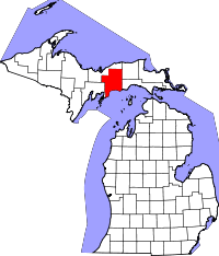 | |
| Townships | ||
| Unincorporated communities | ||