Paul, Cape Verde
| Paul | |
|---|---|
| Municipality | |
 | |
| Coordinates: 17°07′N 25°01′W / 17.12°N 25.01°WCoordinates: 17°07′N 25°01′W / 17.12°N 25.01°W | |
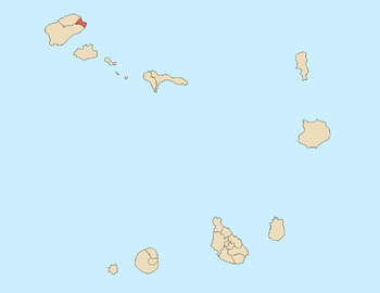
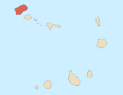
| Country | Cape Verde |
| Island | Santo Antão |
| Area | |
| • Total | 54.26 km2 (20.95 sq mi) |
| Population (2010)[1] | |
| • Total | 6,997 |
| • Density | 130/km2 (330/sq mi) |
| Postal code | 11xx |
Paul is a concelho (municipality) of Cape Verde. Situated in the northeastern part of the island of Santo Antão, it covers 7% of the island area, and is home to 16% of its population. Its seat is the town Pombas.
The municipality and parish
The municipality consists of one freguesia (civil parish), Santo António das Pombas. The freguesia is subdivided into the following settlements (population at the 2010 census):
- Cabo da Ribeira (pop: 912)
- Campo de Cão (pop: 787)
- Eito (pop: 979)
- Figueiral (pop: 591)
- Janela (pop: 1,658)
- Pico da Cruz (pop: 138)
- Pombas (pop: 1,295, city)[2]
- Ribeira das Pombas (pop: 411)
- Ribeirãozinho (pop: 27)
- Santa Isabel (pop: 186)
Demography
| Population of Paul, Cape Verde (1940—2010) | |||||||
|---|---|---|---|---|---|---|---|
| 1940[3] | 1950[3] | 1960[3] | 1970[3] | 1980[3] | 1990[3] | 2000[4] | 2010[5] |
| 5845 | 5370 | 6024 | 8000 | 7983 | 8121 | 8385 | 6997 |
Geography
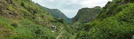
The municipality has a rugged landscape, defined by the mountain valleys of the rivers Ribeira do Paul, Ribeira das Pombas, Ribeira de Gil, Ribeira da Janela, Ribeira do Penedo and Ribeira da Aguada. Its southwesternmost point is formed by the Cova Caldera. Its highest point is Pico da Cruz, at 1585 m elevation. The Cova-Paul-Ribeira da Torre Natural Park lies partly in the municipality of Paul. The national roads EN1-SA02 and EN1-SA03 connect Pombas with Ribeira Grande and Porto Novo, respectively.
History
In 1867 the municipalities of Paul (covering the area of current Paul and Porto Novo) and Ribeira Grande were created from the previous municipality that covered the whole island of Santo Antão. These were merged in 1895 into one municipality, and recreated in 1917. In 1962 the municipality of Paul received its current borders, when the new municipality of Porto Novo was created.[6]
Notable people
- Antoninho Travadinha, commonly known as Travadinha, an autodidactic musician
Politics
Since 2012, the Movement for Democracy (MpD) is the ruling party of the municipality. The results of the latest elections, in 2016:[7]
| Party | Municipal Council | Municipal Assembly | ||
|---|---|---|---|---|
| Votes% | Seats | Votes% | Seats | |
| MpD | 55.29 | 5 | 54.95 | 8 |
| PAICV | 38.03 | 0 | 37.23 | 5 |
| UCID | 3.77 | 0 | 4.33 | 0 |
Sister cities
Paul has five sister municipalities, all of them are in Portugal: Almodôvar, Benavente, Gavião, Odivelas and Sernancelhe.[8]
References
- ↑ "2010 Census results". Instituto Nacional de Estatística Cabo Verde (in Portuguese). 24 November 2016.
- ↑ Cabo Verde, Statistical Yearbook 2015, Instituto Nacional de Estatística, p. 32-33
- 1 2 3 4 5 6 Source: Statoids
- ↑ Source: Instituto Nacional de Estatísticas Archived 2008-11-18 at the Wayback Machine..
- ↑ "2010 Census results Santo Antão". Instituto Nacional de Estatística Cabo Verde (in Portuguese). 23 March 2014.
- ↑ Inventário dos recursos turísticos do município do Paúl, Direcção Geral do Turismo, p. 16
- ↑ Official results local elections 2016, Boletim Oficial I Série, Número 53, 23 September 2016
- ↑ Geminações de Cidades e Vilas
External links
| Wikimedia Commons has media related to Paul (Cape Verde). |
- ANMCV (Associação Nacional dos Municípios Cabo-Verdianos - National Association of the Capeverdean Municipalities)
- Official Paul Tourism Website by Municipal Council of Paul
Subdivisions of the island of Santo Antão | |||||||||
|---|---|---|---|---|---|---|---|---|---|
| Paul |
|  | |||||||
| Porto Novo |
| ||||||||
| Ribeira Grande |
| ||||||||
| Authority control |
|---|