Straumen, Nordland
| Straumen | |
|---|---|
| Village | |
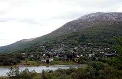 View of the village | |
 Straumen Location in Nordland  Straumen Straumen (Norway) | |
| Coordinates: 67°20′53″N 15°35′49″E / 67.34806°N 15.59694°ECoordinates: 67°20′53″N 15°35′49″E / 67.34806°N 15.59694°E | |
| Country | Norway |
| Region | Northern Norway |
| County | Nordland |
| District | Salten |
| Municipality | Sørfold |
| Area[1] | |
| • Total | 0.73 km2 (0.28 sq mi) |
| Elevation[2] | 9 m (30 ft) |
| Population (2013)[1] | |
| • Total | 797 |
| • Density | 1,092/km2 (2,830/sq mi) |
| Time zone | UTC+01:00 (CET) |
| • Summer (DST) | UTC+02:00 (CEST) |
| Post Code | 8226 Straumen |
Straumen is a village and the administrative centre of the municipality of Sørfold in Nordland county, Norway. It is located at the end of the Sørfolda fjord, along the European route E06 highway. The lake Straumvatnet lies on the southeastern side of the village.[3]
The 0.73-square-kilometre (180-acre) village has a population (2013) of 797, making it the largest settlement in Sørfold. The population density for the village is 1,092 inhabitants per square kilometre (2,830/sq mi).[1]
References
- 1 2 3 Statistisk sentralbyrå (1 January 2013). "Urban settlements. Population and area, by municipality".
- ↑ "Straumen" (in Norwegian). yr.no. Retrieved 2012-04-16.
- ↑ Store norske leksikon. "Straumen – Sørfold" (in Norwegian). Retrieved 2012-04-16.
This article is issued from
Wikipedia.
The text is licensed under Creative Commons - Attribution - Sharealike.
Additional terms may apply for the media files.