Royan
| Royan | ||
|---|---|---|
| Commune | ||
 | ||
| ||
 Royan Location within Nouvelle-Aquitaine region  Royan | ||
| Coordinates: 45°37′N 1°02′W / 45.62°N 1.03°WCoordinates: 45°37′N 1°02′W / 45.62°N 1.03°W | ||
| Country | France | |
| Region | Nouvelle-Aquitaine | |
| Department | Charente-Maritime | |
| Arrondissement | Rochefort | |
| Canton | Royan | |
| Intercommunality | Communauté d'agglomération Royan Atlantique | |
| Government | ||
| • Mayor (2017–2020) | Patrick Marengo | |
| Area1 | 19.30 km2 (7.45 sq mi) | |
| Population (2015)2 | 18,393 | |
| • Density | 950/km2 (2,500/sq mi) | |
| Time zone | UTC+1 (CET) | |
| • Summer (DST) | UTC+2 (CEST) | |
| INSEE/Postal code | 17306 /17200 | |
| Elevation |
0–35 m (0–115 ft) (avg. 20 m or 66 ft) | |
|
1 French Land Register data, which excludes lakes, ponds, glaciers > 1 km2 (0.386 sq mi or 247 acres) and river estuaries. 2 Population without double counting: residents of multiple communes (e.g., students and military personnel) only counted once. | ||
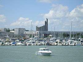
Royan (French pronunciation: [ʁwa.jɑ̃]; locally [ʁwe.jɑ̃] in Saintongeais dialect) is a commune in the south-west of France, located in the Department of Charente-Maritime in the region of Nouvelle-Aquitaine. Its inhabitants are known as Royannais and Royannaises.[1] With five beaches, a marina for over 1,000 boats, and an active fishing port, Royan is one of the main French Atlantic coastal resorts, and is the capital of the Côte de Beauté. As of 2013, the population of the greater urban area was 48,982. The town had 18,393 inhabitants in 2015.
Royan is located on the peninsula of Arvert, at the mouth of the Gironde estuary on its eastern shore. Royan was once of strategic importance, coveted in particular by the Visigoths and the Vikings. The city became a Protestant stronghold during the Hundred Years' War under English rule, and was besieged and destroyed by Louis XIII. During the Restoration, and especially during the Second Empire, Royan was celebrated for its sea baths. It attracted many artists during the Roaring Twenties.
Allied bombing between September 1944 and April 1945 destroyed the town. Known then as the "martyred city", it was declared a "Laboratory of research on urbanism", and it is now a showcase of the Modernist architecture of the 1950s. It was classified as a Town of Art and History (Ville d'Art et d'Histoire) in 2010.[2] Royan today is a tourist and cultural hub, with some 90,000 visitors each summer season.[3]
Geography
Royan is a seaside resort town situated in the west of the department of Charente-Maritime, in the former province of Saintonge. It lies near the Atlantic coast on the eastern side of the mouth of the Gironde estuary, the largest in Europe. Limestone cliffs alternate along its coastline with the five beaches known locally as conches.
Geology
The city of Royan is built on a calcareous rock plateau dating from the Cretaceous Period (about 150 million years ago). It is bounded by the Pousseau marshes to the north and the Pontaillac marshes to the west. The estuary, the cliffs and the conches were shaped approximately 66 million years ago by the folding of limestone layers as the Alps and the Pyrenees formed.
Transport
Road
Royan is approximately 65 kilometres (40 mi) from the administrative capital (or prefecture) of the department, La Rochelle, by departmental road D 733 and national road (Route nationale, RN) 137. It is 98 km (61 mi) from Bordeaux by departmental road D 730 and the A10 freeway, and 507 km (315 mi) from Paris. Travel time on RN 150 is just under half an hour from Royan to the city of Saintes, the historic capital of Saintonge and an important centre of art and history.
Train
Royan SNCF railway station is the terminus of a line connecting the city to Saintes, Angoulême, and Niort (for the high-speed TGV rail link to Bordeaux and Paris).
Across the Gironde estuary, the station of La Pointe-de-Grave at Le Verdon-sur-Mer connects through the Médoc region to Bordeaux-Saint-Jean station.[4][5]
Airports
The conurbation of Royan does not have its own airport, but Rochefort-Saint-Agnant Airport some 30 km (19 mi) away offers flights to several European destinations, including the British Isles. Also accessible is La Rochelle – Île de Ré Airport, 70 km (43 mi) away. International connections are within reach 100 km (62 mi) to the south, from Bordeaux–Mérignac Airport.
Ferry
The TransGironde car-ferry provides bicycle, car and lorry transport across the Gironde estuary to the Medoc region.[6] The crossing from Royan to Le Verdon-sur-mer takes almost 20 minutes).[7] [8]
Climate
The climate is oceanic: rainfall is relatively moderate in autumn and in winter and the winters are mild. Sea breezes keep summers temperatures moderate. Two winds, the north-westerly noroît and the south-westerly suroît, blow in from the ocean and along the coast of the department. The very high average insolation of 2250 hours a year is comparable to the French Riviera.
Charente-Maritime was the department most affected by Cyclone Martin on December 27, 1999. Winds speeds were recorded of up to 198 kilometres per hour (123 mph) on the island of Oléron and 194 kilometres per hour (121 mph) in Royan, with severe damage to local buildings, woodland, and harbour facilities.
| Climate data for Royan | |||||||||||||
|---|---|---|---|---|---|---|---|---|---|---|---|---|---|
| Month | Jan | Feb | Mar | Apr | May | Jun | Jul | Aug | Sep | Oct | Nov | Dec | Year |
| Average high °C (°F) | 8.5 (47.3) |
9.9 (49.8) |
12.1 (53.8) |
14.7 (58.5) |
17.9 (64.2) |
21.3 (70.3) |
23.8 (74.8) |
23.5 (74.3) |
21.8 (71.2) |
18.0 (64.4) |
12.6 (54.7) |
9.2 (48.6) |
16.1 (61) |
| Daily mean °C (°F) | 5.9 (42.6) |
6.9 (44.4) |
8.7 (47.7) |
11.1 (52) |
14.3 (57.7) |
17.5 (63.5) |
19.8 (67.6) |
19.6 (67.3) |
17.8 (64) |
14.2 (57.6) |
9.4 (48.9) |
6.6 (43.9) |
12.7 (54.9) |
| Average low °C (°F) | 3.4 (38.1) |
4.0 (39.2) |
5.4 (41.7) |
7.4 (45.3) |
10.7 (51.3) |
13.7 (56.7) |
15.8 (60.4) |
15.7 (60.3) |
13.7 (56.7) |
10.5 (50.9) |
6.3 (43.3) |
3.9 (39) |
9.2 (48.6) |
| Average precipitation mm (inches) | 82.5 (3.248) |
66.1 (2.602) |
57.0 (2.244) |
52.7 (2.075) |
61.1 (2.406) |
42.9 (1.689) |
35.1 (1.382) |
46.4 (1.827) |
56.5 (2.224) |
81.6 (3.213) |
91.8 (3.614) |
81.8 (3.22) |
755.3 (29.736) |
| Mean monthly sunshine hours | 84 | 111 | 174 | 212 | 239 | 272 | 305 | 277 | 218 | 167 | 107 | 85 | 2,250 |
| Source: | |||||||||||||
History
Prehistory and antiquity
The site of Royan has been occupied since prehistoric times: cut flints brought to light by archeological excavations give evidence of this. The '‘Santones’', a Celtic people, began to populate the peninsula of Arvert. When the Romans began to arrive, they developed the cultivation of vineyards, the breeding of oysters and the saltern technique. Tibullus celebrates the coast after the victory of Messala, and Ausonius built a residence there. In 418, the Visigoths arrived at Saintes. To protect itself, Royan surrounded itself with walls in 419, the date on which this city is mentioned for the first time in an old collection. Gregory of Tours mentions a usurpation of the church of Royan by the Arian Visigoths. In summer 844, the Vikings came up the Gironde, plundering everything along their path.
Middle Ages

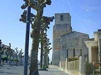
Right image: Saint-Pierre church in 2010
At the beginning of the 11th century, a precarious peace returned, and the peninsula was slowly reborn at the instigation of small seigneuries and abbeys. Between 1050 and 1075, the prieuré of Saint-Vivien de Saintes built Saint Pierre priory on the plateau Saint-Pierre, two kilometres from the village. This fixed a small hamlet. In 1092, the abbey of the Grande-Sauve established another priory, Saint Nicolas, not far from the village. This one is on the rock of Foncillon, by the sea. Attached to the village, a small castle protected the bottom of the beach of Grande Conche which served as a harbour. Already at the end of the 11th century, harbour activity was important. Numerous lighters made the Gironde a stopover waiting for winds or favorable currents. The Lord of Didonne took advantage of this to impose a tax on any boat stopping at the foot of the castle.
In 1137, Eleanor of Aquitaine married the king of France, Louis VII. Royan became an integral part of the duchy of Aquitaine and passed under the direct control of the king of France. But in 1152, the marriage was annulled and Eleanor was married again, to Henri Plantagenet, who became King of England in 1154. Royan then passed under English control.
The King of England strengthened the defences of the village, protecting it with robust bulwarks and a solid donjon. The various taxes paid by ships in the 13th century were codified by the Lords of Royan in 1232, under the name of Coutume (Custom) of Royan. On May 20, 1242, Henry III, king of England, at war against Louis IX (saint Louis), landed at Royan with 300 knights. Beaten at Taillebourg, the English kingdom kept, by the treaty of Paris, control of the South of Saintonge, with the city of Royan. In 1355, during the Hundred Years War, the Black Prince, heir to the throne of England, occupied Saintonge. He strengthened the defences of Royan, which became a large village administered by twelve Echevins and twelve councillors. At the end of the Hundred Years War, in 1451, the region of Royan was definitively part of French kingdom, but the city was totally ruined.
In 1458, Marie de Valois (1444–1473), natural daughter of Charles VII and his mistress Agnès Sorel married Olivier de Coëtivy, Count of Taillebourg. She brought a dowry of 12 000 ecus and the châtellenies of Royan and Mornac. In 1501 Charles de la Trémoille, by his marriage with Louise de Coëtivy, became baron of Royan. Business developed there. But walled up in its ramparts, access to the town was difficult. From the beginning of the 16th century, a suburb developed bordering the beach.
However, in the 16th century, the religious wars raged, and almost all the great captains of the time, such as Henri de Navarre, the future King Henry IV, and the Sire of Brantôme (who would become a prior of Saint-Pierre-de-Royan), fought under the walls of the citadel. In 1592, Henry IV established the city as marquisate to the advantage of Gilbert de la Trémoille. At the beginning of the 17th century, the Duke of Épernon considered that, "it is one of better places of its size in France". After the Edict of Nantes, Royan was a Protestant fortified town under King Henry III.
The strengthened city underwent a first siege in 1622, directed by Louis XIII, but resisted. The second siege in 1623 was terrible for Royannais, who had to abandon the city, with a ban against returning. The garrison had to surrender. In 1631, the fortified town was leveled on the orders of Cardinal Richelieu; the citadel was dismantled, and the ditches were filled in. The city, which no longer had a church, was connected with the rural parish of Saint Pierre.
After the revocation of the Edict of Nantes, the major part of the population emigrated, especially to the Dutch Republic, and the persecution continued under Louis XV. The storm of 1735 destroyed the embankment of its harbour, and navigation was not restored until the 19th century.
French Revolution
When in December 1789, the National Assembly voted for the division of France into departments, instead of the former provinces, they created the département of Charente-Inférieure, and Royan became an administrative centre of the canton from February 4, 1790.
At the same time, they elected a city council, chaired by the Protestant Daniel Renaud, and the mayor Nicolas-Thérese Vallet of Salignac. On July 12, 1790, the National Assembly voted for the civil constitution of the clergy, in the canton of Royan. The priests of the parishes of Royan, Vaux and Saint-Sulpice refused to take the constitutional oath and become prêtres réfractaires, condemned to deportation.
Throughout the country, church properties were seized. In Royan the convent of the Récollets, built in 1622, was put on sale with its 33 hectares (82 acres) and was acquired on February 25, 1791, by Jean Boisseau, a shipowner, who demolished it.
Dissatisfaction due to the economic crisis built in Royan as elsewhere. To address this, clubs celebrating patriotic events were formed. On July 14, 1790, the feast of the federation took place, and a ceremony was organized in Saint Pierre church, on the occasion of the "federative oath". At the end of November, Nicolas-Thérese Vallet of Salignac was removed from office and was replaced by François d' Aulnis de Puiraveaux.
In 1791, Daniel Renaud was elected as mayor of the commune. In May 1791, the club of "the friends of the constitution" was opened in Royan. In general, however, the Terror was hardly noticeable, and few notables were worried.
Seaside resort

Paving of the streets began in 1816 and was finished only in 1826. In July 1819, the mayor, Raymond Labarthe, signed the first prescription regulating sea bathing; this forbade nude bathing from beaches bordering houses and reserved the Foncillon beach for women. In 1820, it was forbidden "to wash pigs, horses and other cattle in the sea as we have baths". In 1836, a staircase was cut out of the rock to facilitate the landing of passengers from boats. By 1845, the engineer Botton wrapped (surrounded) the cliff of Foncillon inside the port. In 1847, the engineer Lessore built the sketch of the first casino. Under the Second Empire, the city underwent much development. In 1854, the first street lights were installed. Between 1850 and 1870, the number of tourists increased from 9000 to 10,000, and the population from 3329 to 4500.
Destruction
During World War II, two German fortresses defended the Gironde Estuary: Gironde Mündung Nord (north, at Royan) and Gironde Mündung Süd (south, at La Pointe de Grave). These constituted one of the Atlantic "pockets" which the Germans held on to, well after the liberation of the rest of France. In the early hours of January 5, 1945, a force of about 350 RAF heavy bombers, at the request of SHAEF[9] (which had been told that nobody was left in Royan but Germans and collaborators) bombed Royan out of existence in two raids. The blame for this raid is usually attributed to Free French General de Larminat.[10]
The Allied operation against the German forces on Île d'Oléron and at the mouth of the Gironde River, began with a general naval bombardment on April 15, 1945, some 10 months after D-Day. For five days, the American naval task force assisted the French ground forces with naval bombardment and aerial reconnaissance in the assault on Royan and the Pointe de Grave area at the mouth of the Gironde. American B-17 Flying Fortress and B-24 Liberator aircraft carried out aerial bombing missions, including extensive and pioneering use of napalm, finishing the destruction of January 5.
The first bombing raids killed over 1,000 civilians and only 23 German soldiers. When the Americans returned later and used napalm, they destroyed the entire city and killed another 1,700 civilians.[11]
Blandford writes, "There was a Free French commander with the U.S. Seventh Army outside Royan, who was not informed until too late. The message was in French and the American signalman could not understand it. It took four hours to get it translated".
Howard Zinn, author of A People's History of the United States, was one of the many bombardiers who attacked Royan during World War II. He later wrote of the bombardment.
Royan today
The town was rebuilt as part of an urban development programme in the 1950s, and is very representative of the Modernist architecture of the period.
Population
Inhabitants of Royan are known as Royannais (for the men) and Royannaises (for the women).
| Historical population | ||
|---|---|---|
| Year | Pop. | ±% |
| 1806 | 2,202 | — |
| 1820 | 2,339 | +6.2% |
| 1876 | 5,155 | +120.4% |
| 1906 | 8,843 | +71.5% |
| 1911 | 9,330 | +5.5% |
| 1921 | 10,242 | +9.8% |
| 1936 | 12,192 | +19.0% |
| 1946 | 6,649 | −45.5% |
| 1954 | 12,289 | +84.8% |
| 1962 | 16,521 | +34.4% |
| 1968 | 17,292 | +4.7% |
| 1975 | 18,062 | +4.5% |
| 1982 | 17,540 | −2.9% |
| 1990 | 16,837 | −4.0% |
| 1999 | 17,102 | +1.6% |
| 2008 | 18,541 | +8.4% |
International relations
Royan is twinned with:


Sights
Church of Notre-Dame (église Notre-Dame)
Built in three years by the architects Guillaume Gillet and Marc Hébrard, in association with the engineers Bernard Lafaille, René Sarger and Ou Tseng, the church Notre-Dame of Royan is considered as one of the leaders of work of the contemporary architecture. The bombardments of January 5, 1945, had destroyed the former neo-Gothic church which dated back to 1877, located at the current Square Charles de Gaulle. It was decided to rebuild as a building of bigger size and with an architecture both ambitious and spectacular, inspired by the aesthetics of other large Gothic cathedrals. Finished in 1958, it is built completely of concrete. The dimensions are: a nave in ellipse, 45 metres long by 22 metres wide (148 ft × 72 ft) which can hold approximately 2000 persons, flanked by an ambulatory and by a gallery situated three metres above the floor. The gallery is lit by stained glass in the form of a rhombus representing the Stations of the Cross. The structure of the building consists of an alternation of elements in reinforced concrete V (Lafaille system, named for the engineer Bernard Lafaille who created the process) alternating with immense windows covering 500 square metres, the work of the glass-worker Henri Martin-Granel. The church was classified as a historical monument in 1988.
Convention Centre (Palais des congrès)
The Palais des congrès was built in 1957 by Bordeaux architect Claude Ferret. Its design is based on cubic geometry, relieved by the oblique lines of external staircases and by the subtle interweaving of convex inner walls. A glass wall opens a broad outlook onto the Gironde estuary, and the building was later extended with gardens under a transparent cube. It was classified as a historical monument in 2004.
Central Market (Marché central)
Built in 1955 by architects Louis Simon and Andre Morisseau and engineer René Sarger, the Central Market is a round concrete shell with walls 8 centimetres (3 in) thick. It rests on thirteen peripheral support-points, and has no internal pillars. The structure is 52.40 metres (171.9 ft) in diameter, with a central height of 10.50 metres (34.4 ft). It served as the model for the market in Nanterre and for the Centre of New Industries and Technologies (CNIT) in the La Défense neighbourhood of Paris.
Education

Royan attracts many foreign-language students due to its local language university, le CAREL (Centre Audiovisuel de Royan pour l'Étude des Langues). It is frequented by thousands of students from around 80 countries, and consists of 20 soundproof audiovisual rooms, 4 language laboratories, an auditorium, a library, a television studio and a self-service cafe for the students. It prepares students for the examinations of the DALF, DELF, TCF and TFI.
The colleges include: the Collège Émile Zola, the Collège Henry Dunant and the Collège Sainte-Marie.
The lycées include: the Lycée de l'Atlantique and the Lycée de Cordouan.
Sports
The main stadium of the city is the stadium of honour (stade d'honneur in French), situated near the railway station. Royan has numerous other sports facilities, including: two swimming-pools, of which one (at Foncillon) is an outdoor sea water pool opened in the summer; several gymnasiums; a sports hall; several tennis courts; a Basque pelota wall; a rugby groun; and a golf course.
A surf-club is also based in the commune, near Pontaillac beach, as well as a karting circuit (KFM - Circuit of the côte de beauté).
A racecourse, a riding school and an 18-hole golf course, are in nearby La Palmyre, in the commune of Les Mathes.
On June 18–24, 2017 the WFDF World Championships of Beach Ultimate were held in Royan.
Personalities
Royan was the birthplace of:
- Pierre Dugua, Sieur de Mons, (ca 1558–1628), merchant, explorer and colonizer
- Eugène Pelletan (1813–84), writer, journalist and politician
- Jeanne Pelisson-Mallet (1873–1961), painter
Visitors:
See also
References
- ↑ "" Habitants.fr : Royan "".
- ↑ "" Royan sacrée ville d'Art et d'histoire "".
- ↑ "" Royan en chiffres "".
- ↑ SNCF 'Le Verdon' to 'Bordaux St-Jean'
- ↑ fr:Ligne du Médoc
- ↑
- ↑ Les Ferrys (only in france)
- ↑ Transgironde.fr
- ↑ Bomber Command Diary January 1945 Archived June 11, 2007, at the Wayback Machine.
- ↑ The Zinn reader: writings on disobedience and democracy, Howard Zinn; page 275 ff. google books
- ↑ Zinn, Howard (1997). The Zinn Reader. Seven Stories Press. p. 271. ISBN 978-1-583229-46-0.
External links
| Wikimedia Commons has media related to Royan. |
| Wikisource has the text of the 1911 Encyclopædia Britannica article Royan. |
- Official website (in French)
- Tourist office website
- Royan information (in French)
- Vidéorama touristique sur Royan
- Royan from fr.wikipedia.org